Siluko elevation
Siluko (Edo, Ovia South-West), Nigeria elevation is 51 meters and Siluko elevation in feet is 167 ft above sea level [src 1]. Siluko is a populated place (feature code) with elevation that is 246 meters (807 ft) smaller than average city elevation in Nigeria.
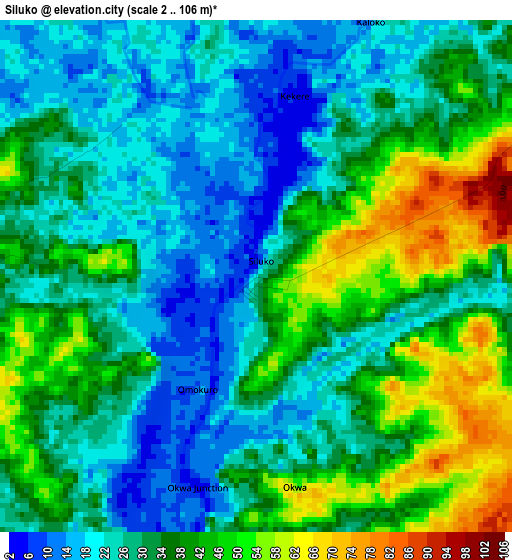
Below is the Elevation map of Siluko, which displays elevation range with different colors. Scale of the first map is from 2 to 106 m (7 to 348 ft) with average elevation of 32.8 meters (=108 ft) [note 1]
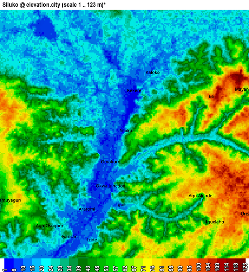
These maps also provides idea of topography and contour of this city, they are displayed at different zoom levels. More info about maps, scale and edge coordinates you can find below images.
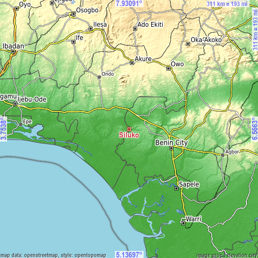
| \ | Map #1 | Map #2 | Topo.Map |
| Scale [m] | 2..106 m | 1..123 m | × |
| Scale [ft] | 7..348 ft | 3..404 ft | × |
| Average | 32.8 m = 108 ft | 41.2 m = 135 ft | × |
| Width | 9.71 km = 6 mi | 19.42 km = 12.1 mi | 310.7 km = 193.1 mi |
| Height | 9.71 km = 6 mi | 19.42 km = 12.1 mi | 310.7 km = 193.1 mi |
| ↑Max Latitude | 6.579548° | 6.623202° | 7.93091° |
| Latitude at center | 6.53589° | 6.53589° | 6.53589° |
| ↓Min Latitude | 6.492228° | 6.448563° | 5.13697° |
| ← Min Longitude | 5.116105° | 5.072159° | 3.7538° |
| Longitude center | 5.16005° | 5.16005° | 5.16005° |
| →Max Longitude | 5.203995° | 5.247941° | 6.5663° |
Nearby cities:
Cities around Siluko sort by population:
• Benin City elevation 88 m
56 km,  113°
113°
• Idanre 332 m
64.3 km,  355°
355°
• Ore 76 m
39.2 km,  306°
306°
• Agbabu 12 m
36.5 km,  279°
279°
• Idogbo 66 m
68 km,  115°
115°
• Koko 14 m
67.9 km,  151°
151°
• Uselu 110 m
52.5 km, 108°
• Igbokoda 7 m
44.3 km,  242°
242°
• Igbekebo 15 m
38.6 km, 238°
• Okada 74 m
34.1 km,  49°
49°
• Ode-Irele 41 m
32.3 km,  261°
261°
• Iguobazuwa 128 m
21.7 km,  81°
81°
Multilingual:
 En español:
Siluko elevación 51 m.
 En France:
Siluko élévation 51 m.


Sources and notes:
- [note 1] Map square and city borders are not equal. Map elevation data is calculated only from area inside that square.
- [src 1] Elevation data from geonames database provided with same terms of usage.
- [src 2] The elevation map of Siluko is generated using elevation data from NASA's 3 arcsec (90m) resolution SRTM data.
- [src 3] Base (background) map © OpenStreetMap contributors tiles are generated by Geofabrik and OpenTopoMap.
Copyright & License:
This Siluko Elevation Map is licensed under CC BY-SA. You may reuse any part from this page, if you give a proper credit by linking to this URL:
 More info on terms of use page.