Ore elevation
Ore (Ondo, Odigbo), Nigeria elevation is 76 meters and Ore elevation in feet is 249 ft above sea level [src 1]. Ore is a seat of a second-order administrative division (feature code) with elevation that is 221 meters (725 ft) smaller than average city elevation in Nigeria.
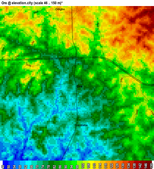
Below is the Elevation map of Ore, which displays elevation range with different colors. Scale of the first map is from 46 to 150 m (151 to 492 ft) with average elevation of 88.3 meters (=290 ft) [note 1]
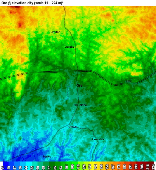
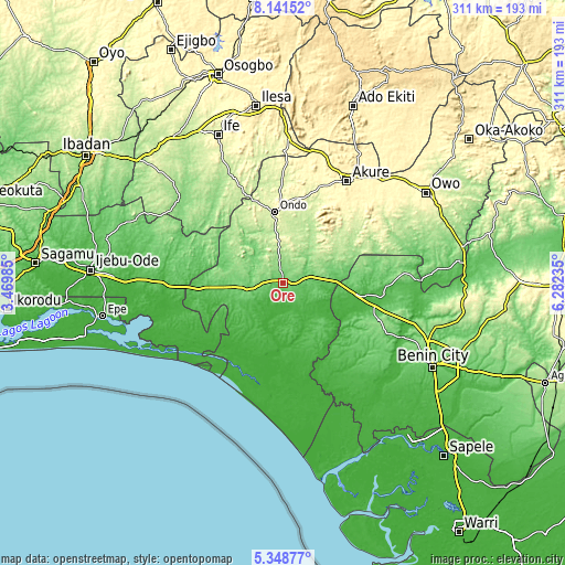
These maps also provides idea of topography and contour of this city, they are displayed at different zoom levels. More info about maps, scale and edge coordinates you can find below images.
| \ | Map #1 | Map #2 | Topo.Map |
| Scale [m] | 46..150 m | 11..224 m | × |
| Scale [ft] | 151..492 ft | 36..735 ft | × |
| Average | 88.3 m = 290 ft | 93.6 m = 307 ft | × |
| Width | 9.7 km = 6 mi | 19.41 km = 12.1 mi | 310.5 km = 192.9 mi |
| Height | 9.7 km = 6 mi | 19.41 km = 12.1 mi | 310.6 km = 193 mi |
| ↑Max Latitude | 6.790799° | 6.834434° | 8.14152° |
| Latitude at center | 6.74716° | 6.74716° | 6.74716° |
| ↓Min Latitude | 6.703517° | 6.65987° | 5.34877° |
| ← Min Longitude | 4.832155° | 4.788209° | 3.46985° |
| Longitude center | 4.8761° | 4.8761° | 4.8761° |
| →Max Longitude | 4.920045° | 4.963991° | 6.28235° |
Nearby cities:
Cities around Ore sort by population:
• Ondo elevation 263 m
38.7 km,  353°
353°
• Idanre 332 m
48.5 km,  33°
33°
• Agbabu 12 m
18.2 km,  194°
194°
• Siluko 51 m
39.2 km,  126°
126°
• Iguobazuwa 128 m
56.6 km,  110°
110°
• Ifetedo 217 m
52.3 km,  338°
338°
• Owena 249 m
52.3 km,  18°
18°
• Ile-Oluji 240 m
51.8 km,  359°
359°
• Bolorunduro 275 m
47.5 km,  11°
11°
• Igbokoda 7 m
44.6 km, 190°
• Igbekebo 15 m
43.6 km,  182°
182°
• Ode-Irele 41 m
28.1 km, 181°
Multilingual:
 En español:
Ore elevación 76 m.
 En France:
Ore élévation 76 m.


Sources and notes:
- [note 1] Map square and city borders are not equal. Map elevation data is calculated only from area inside that square.
- [src 1] Elevation data from geonames database provided with same terms of usage.
- [src 2] The elevation map of Ore is generated using elevation data from NASA's 3 arcsec (90m) resolution SRTM data.
- [src 3] Base (background) map © OpenStreetMap contributors tiles are generated by Geofabrik and OpenTopoMap.
Copyright & License:
This Ore Elevation Map is licensed under CC BY-SA. You may reuse any part from this page, if you give a proper credit by linking to this URL:
 More info on terms of use page.