Ondo elevation
Ondo, Nigeria elevation is 263 meters and Ondo elevation in feet is 863 ft above sea level [src 1]. Ondo is a seat of a second-order administrative division (feature code) with elevation that is 34 meters (112 ft) smaller than average city elevation in Nigeria.
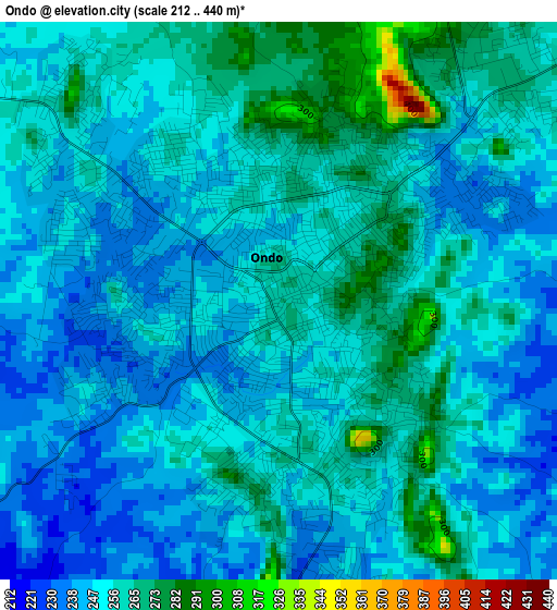
Below is the Elevation map of Ondo, which displays elevation range with different colors. Scale of the first map is from 212 to 440 m (696 to 1444 ft) with average elevation of 253.2 meters (=831 ft) [note 1]
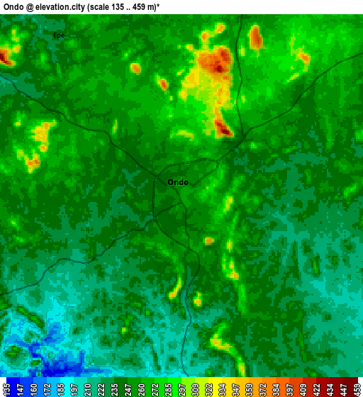
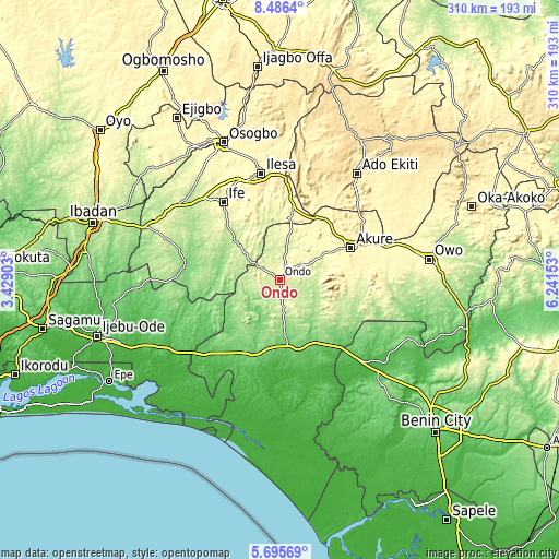
These maps also provides idea of topography and contour of this city, they are displayed at different zoom levels. More info about maps, scale and edge coordinates you can find below images.
| \ | Map #1 | Map #2 | Topo.Map |
| Scale [m] | 212..440 m | 135..459 m | × |
| Scale [ft] | 696..1444 ft | 443..1506 ft | × |
| Average | 253.2 m = 831 ft | 246.2 m = 808 ft | × |
| Width | 9.7 km = 6 mi | 19.4 km = 12.1 mi | 310.3 km = 192.8 mi |
| Height | 9.7 km = 6 mi | 19.4 km = 12.1 mi | 310.3 km = 192.8 mi |
| ↑Max Latitude | 7.136767° | 7.18037° | 8.4864° |
| Latitude at center | 7.09316° | 7.09316° | 7.09316° |
| ↓Min Latitude | 7.049549° | 7.005934° | 5.69569° |
| ← Min Longitude | 4.791335° | 4.747389° | 3.42903° |
| Longitude center | 4.83528° | 4.83528° | 4.83528° |
| →Max Longitude | 4.879225° | 4.923171° | 6.24153° |
Nearby cities:
Cities around Ondo sort by population:
• Akure elevation 353 m
43.3 km,  65°
65°
• Idanre 332 m
31 km,  85°
85°
• Igbara-Odo 367 m
52 km,  28°
28°
• Ore 76 m
38.7 km,  173°
173°
• Ilare 348 m
42 km,  46°
46°
• Ile-Ife 295 m
52.8 km,  324°
324°
• Iperindo 303 m
45.5 km,  358°
358°
• Igbara-Oke 353 m
43.1 km, 34°
• Owena 249 m
23.5 km,  61°
61°
• Ifetedo 217 m
18 km,  304°
304°
• Bolorunduro 275 m
16.3 km, 60°
• Ile-Oluji 240 m
13.8 km,  15°
15°
Multilingual:
 En español:
Ondo elevación 263 m.
 En France:
Ondo élévation 263 m.


Sources and notes:
- [note 1] Map square and city borders are not equal. Map elevation data is calculated only from area inside that square.
- [src 1] Elevation data from geonames database provided with same terms of usage.
- [src 2] The elevation map of Ondo is generated using elevation data from NASA's 3 arcsec (90m) resolution SRTM data.
- [src 3] Base (background) map © OpenStreetMap contributors tiles are generated by Geofabrik and OpenTopoMap.
Copyright & License:
This Ondo Elevation Map is licensed under CC BY-SA. You may reuse any part from this page, if you give a proper credit by linking to this URL:
 More info on terms of use page.