Kwatarkwashi elevation
Kwatarkwashi (Zamfara, Bungudu), Nigeria elevation is 483 meters and Kwatarkwashi elevation in feet is 1585 ft above sea level [src 1]. Kwatarkwashi is a populated place (feature code) with elevation that is 186 meters (610 ft) bigger than average city elevation in Nigeria.
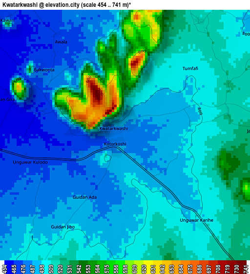
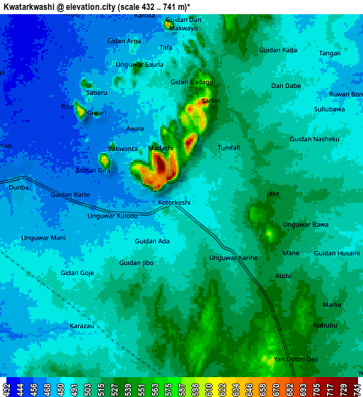
Below is the Elevation map of Kwatarkwashi, which displays elevation range with different colors. Scale of the first map is from 454 to 741 m (1490 to 2431 ft) with average elevation of 505.6 meters (=1659 ft) [note 1]
These maps also provides idea of topography and contour of this city, they are displayed at different zoom levels. More info about maps, scale and edge coordinates you can find below images.
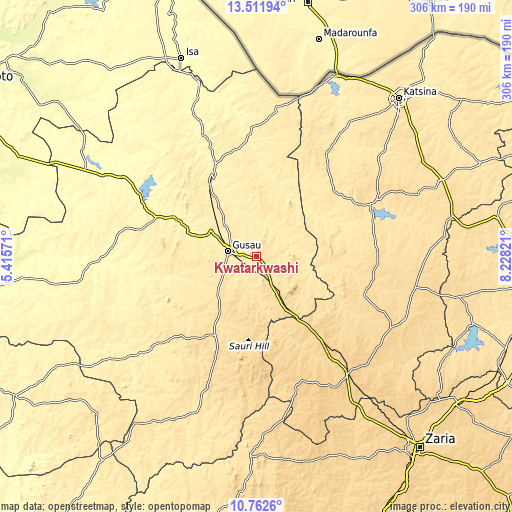
| \ | Map #1 | Map #2 | Topo.Map |
| Scale [m] | 454..741 m | 432..741 m | × |
| Scale [ft] | 1490..2431 ft | 1417..2431 ft | × |
| Average | 505.6 m = 1659 ft | 497 m = 1631 ft | × |
| Width | 9.55 km = 5.9 mi | 19.11 km = 11.9 mi | 305.7 km = 190 mi |
| Height | 9.55 km = 5.9 mi | 19.11 km = 11.9 mi | 305.7 km = 190 mi |
| ↑Max Latitude | 12.183779° | 12.226731° | 13.51194° |
| Latitude at center | 12.14082° | 12.14082° | 12.14082° |
| ↓Min Latitude | 12.097854° | 12.054881° | 10.7626° |
| ← Min Longitude | 6.778015° | 6.734069° | 5.41571° |
| Longitude center | 6.82196° | 6.82196° | 6.82196° |
| →Max Longitude | 6.865905° | 6.909851° | 8.22821° |
Nearby cities:
Cities around Kwatarkwashi sort by population:
• Gusau elevation 451 m
17.5 km,  280°
280°
• Kaura Namoda 396 m
56.5 km,  333°
333°
• Sauri 612 m
46.2 km,  185°
185°
• Runka 489 m
63 km,  57°
57°
• Maru 381 m
50.2 km,  295°
295°
• Kankara 595 m
68.2 km,  109°
109°
• Tsafe 565 m
23 km,  152°
152°
• Zurmi 397 m
70.8 km,  356°
356°
• Dan Musa 492 m
57.3 km,  76°
76°
• Faskari 629 m
51.9 km, 154°
• Birnin Magaji 428 m
47.2 km,  9°
9°
• Bungudu 413 m
32.5 km, 295°
Multilingual:
 En español:
Kwatarkwashi elevación 483 m.
 En France:
Kwatarkwashi élévation 483 m.
 Auf Deutsch:
Kwatarkwashi höhe über dem Meeresspiegel ist 483 m.

Sources and notes:
- [note 1] Map square and city borders are not equal. Map elevation data is calculated only from area inside that square.
- [src 1] Elevation data from geonames database provided with same terms of usage.
- [src 2] The elevation map of Kwatarkwashi is generated using elevation data from NASA's 3 arcsec (90m) resolution SRTM data.
- [src 3] Base (background) map © OpenStreetMap contributors tiles are generated by Geofabrik and OpenTopoMap.
Copyright & License:
This Kwatarkwashi Elevation Map is licensed under CC BY-SA. You may reuse any part from this page, if you give a proper credit by linking to this URL:
 More info on terms of use page.