Shaffa elevation
Shaffa (Borno, Hawul), Nigeria elevation is 649 meters and Shaffa elevation in feet is 2129 ft above sea level [src 1]. Shaffa is a populated place (feature code) with elevation that is 352 meters (1155 ft) bigger than average city elevation in Nigeria.
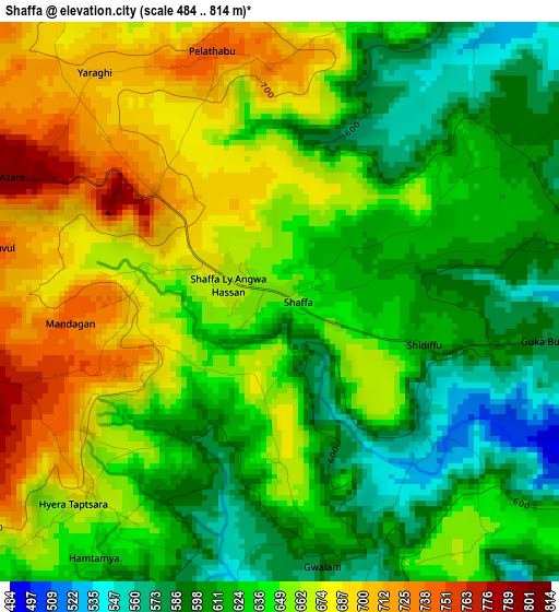
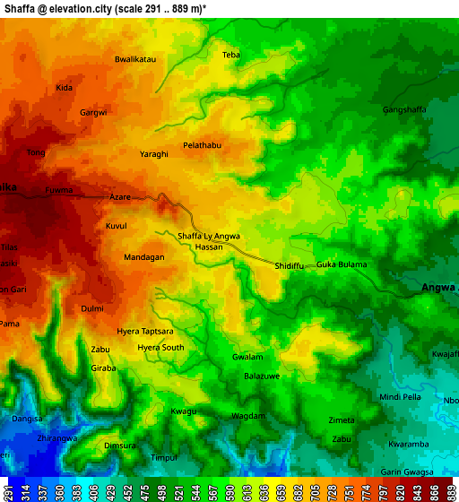
Below is the Elevation map of Shaffa, which displays elevation range with different colors. Scale of the first map is from 484 to 814 m (1588 to 2671 ft) with average elevation of 641.4 meters (=2104 ft) [note 1]
These maps also provides idea of topography and contour of this city, they are displayed at different zoom levels. More info about maps, scale and edge coordinates you can find below images.
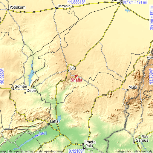
| \ | Map #1 | Map #2 | Topo.Map |
| Scale [m] | 484..814 m | 291..889 m | × |
| Scale [ft] | 1588..2671 ft | 955..2917 ft | × |
| Average | 641.4 m = 2104 ft | 600.1 m = 1969 ft | × |
| Width | 9.61 km = 6 mi | 19.22 km = 11.9 mi | 307.4 km = 191 mi |
| Height | 9.61 km = 6 mi | 19.22 km = 11.9 mi | 307.5 km = 191.1 mi |
| ↑Max Latitude | 10.549935° | 10.593135° | 11.88618° |
| Latitude at center | 10.50673° | 10.50673° | 10.50673° |
| ↓Min Latitude | 10.463518° | 10.420301° | 9.12109° |
| ← Min Longitude | 12.289205° | 12.245259° | 10.9269° |
| Longitude center | 12.33315° | 12.33315° | 12.33315° |
| →Max Longitude | 12.377095° | 12.421041° | 13.7394° |
Nearby cities:
Cities around Shaffa sort by population:
• Biu elevation 762 m
19.2 km,  307°
307°
• Gombi 597 m
58.1 km,  130°
130°
• Shani 239 m
43.8 km,  222°
222°
• Miringa 659 m
32.2 km,  320°
320°
• Wuyo 312 m
70.9 km,  259°
259°
• Guyuk 217 m
80.1 km,  213°
213°
• Shelleng 185 m
76.7 km, 207°
• Hong 539 m
71.8 km,  115°
115°
• Chibok 464 m
69.1 km,  54°
54°
• Askira 467 m
64.9 km,  75°
75°
• Kwaya Kusar 359 m
53.6 km,  269°
269°
• Azare 796 m
5.1 km,  294°
294°
Multilingual:
 En español:
Shaffa elevación 649 m.
 En France:
Shaffa élévation 649 m.


Sources and notes:
- [note 1] Map square and city borders are not equal. Map elevation data is calculated only from area inside that square.
- [src 1] Elevation data from geonames database provided with same terms of usage.
- [src 2] The elevation map of Shaffa is generated using elevation data from NASA's 3 arcsec (90m) resolution SRTM data.
- [src 3] Base (background) map © OpenStreetMap contributors tiles are generated by Geofabrik and OpenTopoMap.
Copyright & License:
This Shaffa Elevation Map is licensed under CC BY-SA. You may reuse any part from this page, if you give a proper credit by linking to this URL:
 More info on terms of use page.