Gombi elevation
Gombi (Adamawa), Nigeria elevation is 597 meters and Gombi elevation in feet is 1959 ft above sea level [src 1]. Gombi is a seat of a second-order administrative division (feature code) with elevation that is 300 meters (984 ft) bigger than average city elevation in Nigeria.
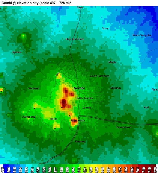
Below is the Elevation map of Gombi, which displays elevation range with different colors. Scale of the first map is from 497 to 728 m (1631 to 2388 ft) with average elevation of 563.5 meters (=1849 ft) [note 1]
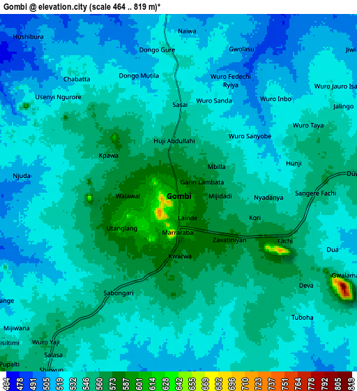
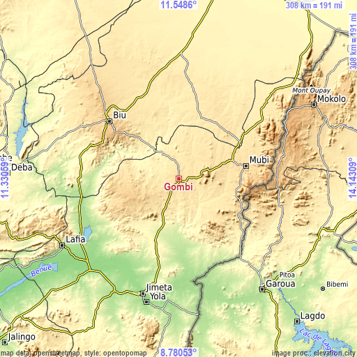
These maps also provides idea of topography and contour of this city, they are displayed at different zoom levels. More info about maps, scale and edge coordinates you can find below images.
| \ | Map #1 | Map #2 | Topo.Map |
| Scale [m] | 497..728 m | 464..819 m | × |
| Scale [ft] | 1631..2388 ft | 1522..2687 ft | × |
| Average | 563.5 m = 1849 ft | 536.8 m = 1761 ft | × |
| Width | 9.62 km = 6 mi | 19.24 km = 12 mi | 307.8 km = 191.3 mi |
| Height | 9.62 km = 6 mi | 19.24 km = 12 mi | 307.8 km = 191.3 mi |
| ↑Max Latitude | 10.210812° | 10.254059° | 11.5486° |
| Latitude at center | 10.16756° | 10.16756° | 10.16756° |
| ↓Min Latitude | 10.124302° | 10.081038° | 8.78053° |
| ← Min Longitude | 12.692895° | 12.648949° | 11.33059° |
| Longitude center | 12.73684° | 12.73684° | 12.73684° |
| →Max Longitude | 12.780785° | 12.824731° | 14.14309° |
Nearby cities:
Cities around Gombi sort by population:
• Mubi elevation 582 m
59.1 km,  79°
79°
• Biu 762 m
77.3 km,  309°
309°
• Shani 239 m
74.2 km,  274°
274°
• Uba 496 m
62 km,  58°
58°
• Holma 570 m
45.9 km,  130°
130°
• Shaffa 649 m
58.1 km, 310°
• Azare 796 m
63 km, 309°
• Gella 812 m
61.6 km,  91°
91°
• Askira 467 m
56.9 km,  19°
19°
• Maiha 605 m
55.9 km,  109°
109°
• Song 307 m
39.9 km,  198°
198°
• Hong 539 m
22.2 km,  70°
70°
Multilingual:
 En español:
Gombi elevación 597 m.
 En France:
Gombi élévation 597 m.


Sources and notes:
- [note 1] Map square and city borders are not equal. Map elevation data is calculated only from area inside that square.
- [src 1] Elevation data from geonames database provided with same terms of usage.
- [src 2] The elevation map of Gombi is generated using elevation data from NASA's 3 arcsec (90m) resolution SRTM data.
- [src 3] Base (background) map © OpenStreetMap contributors tiles are generated by Geofabrik and OpenTopoMap.
Copyright & License:
This Gombi Elevation Map is licensed under CC BY-SA. You may reuse any part from this page, if you give a proper credit by linking to this URL:
 More info on terms of use page.