Shelleng elevation
Shelleng (Adamawa), Nigeria elevation is 185 meters and Shelleng elevation in feet is 607 ft above sea level [src 1]. Shelleng is a seat of a second-order administrative division (feature code) with elevation that is 112 meters (367 ft) smaller than average city elevation in Nigeria.
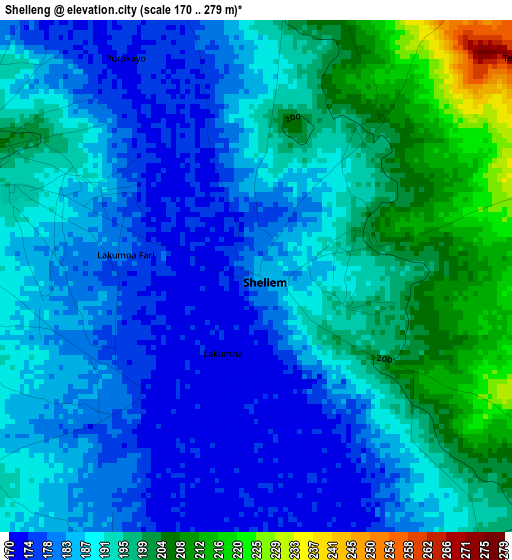
Below is the Elevation map of Shelleng, which displays elevation range with different colors. Scale of the first map is from 170 to 279 m (558 to 915 ft) with average elevation of 189.8 meters (=623 ft) [note 1]
These maps also provides idea of topography and contour of this city, they are displayed at different zoom levels. More info about maps, scale and edge coordinates you can find below images.
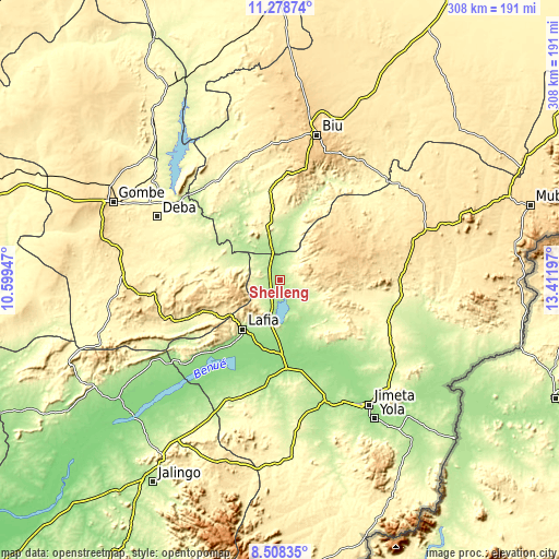
| \ | Map #1 | Topo.Map |
| Scale [m] | 170..279 m | × |
| Scale [ft] | 558..915 ft | × |
| Average | 189.8 m = 623 ft | × |
| Width | 9.63 km = 6 mi | 308 km = 191.4 mi |
| Height | 9.63 km = 6 mi | 308.1 km = 191.4 mi |
| ↑Max Latitude | 9.939759° | 11.27874° |
| Latitude at center | 9.89647° | 9.89647° |
| ↓Min Latitude | 9.853176° | 8.50835° |
| ← Min Longitude | 11.961775° | 10.59947° |
| Longitude center | 12.00572° | 12.00572° |
| →Max Longitude | 12.049665° | 13.41197° |
Nearby cities:
Cities around Shelleng sort by population:
• Numan elevation 161 m
48.2 km,  176°
176°
• Shani 239 m
36.3 km,  9°
9°
• Wuyo 312 m
64 km,  328°
328°
• Hinna 221 m
71.6 km,  309°
309°
• Dadiya 349 m
70 km,  243°
243°
• Kwaya Kusar 359 m
69.7 km,  345°
345°
• Song 307 m
68.2 km,  96°
96°
• Briyel 240 m
66.3 km,  319°
319°
• Demsa 152 m
51.6 km,  161°
161°
• Lamurde 180 m
39.6 km,  216°
216°
• Talasse 297 m
36.6 km,  282°
282°
• Guyuk 217 m
8.6 km, 277°
Multilingual:
 En español:
Shelleng elevación 185 m.
 En France:
Shelleng élévation 185 m.
 Auf Deutsch:
Shelleng höhe über dem Meeresspiegel ist 185 m.

Sources and notes:
- [note 1] Map square and city borders are not equal. Map elevation data is calculated only from area inside that square.
- [src 1] Elevation data from geonames database provided with same terms of usage.
- [src 2] The elevation map of Shelleng is generated using elevation data from NASA's 3 arcsec (90m) resolution SRTM data.
- [src 3] Base (background) map © OpenStreetMap contributors tiles are generated by Geofabrik and OpenTopoMap.
Copyright & License:
This Shelleng Elevation Map is licensed under CC BY-SA. You may reuse any part from this page, if you give a proper credit by linking to this URL:
 More info on terms of use page.