Numan elevation
Numan (Adamawa), Nigeria elevation is 161 meters and Numan elevation in feet is 528 ft above sea level [src 1]. Numan is a seat of a second-order administrative division (feature code) with elevation that is 136 meters (446 ft) smaller than average city elevation in Nigeria.
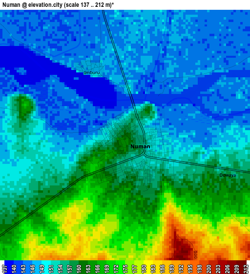
Below is the Elevation map of Numan, which displays elevation range with different colors. Scale of the first map is from 137 to 212 m (449 to 696 ft) with average elevation of 155.4 meters (=510 ft) [note 1]
These maps also provides idea of topography and contour of this city, they are displayed at different zoom levels. More info about maps, scale and edge coordinates you can find below images.
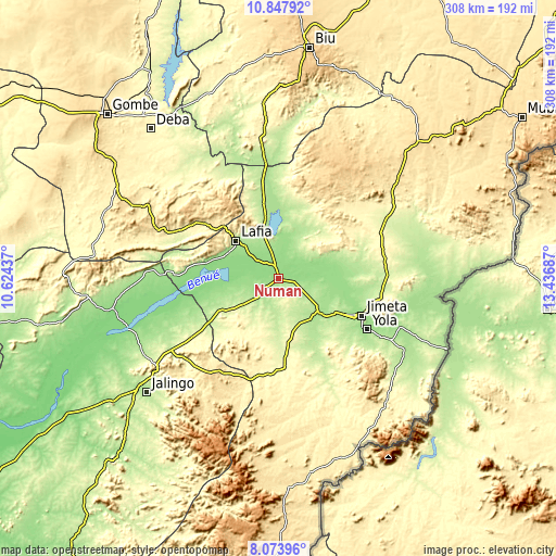
| \ | Map #1 | Map #2 | Topo.Map |
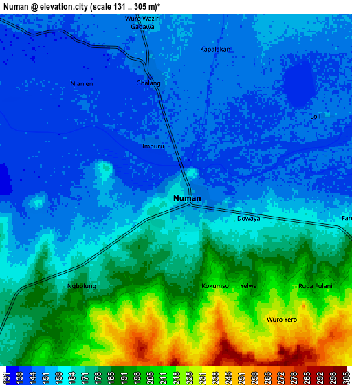
| Scale [m] | 137..212 m | 131..305 m | × |
| Scale [ft] | 449..696 ft | 430..1001 ft | × |
| Average | 155.4 m = 510 ft | 168.8 m = 554 ft | × |
| Width | 9.64 km = 6 mi | 19.28 km = 12 mi | 308.4 km = 191.6 mi |
| Height | 9.64 km = 6 mi | 19.28 km = 12 mi | 308.5 km = 191.7 mi |
| ↑Max Latitude | 9.507084° | 9.550423° | 10.84792° |
| Latitude at center | 9.46374° | 9.46374° | 9.46374° |
| ↓Min Latitude | 9.42039° | 9.377035° | 8.07396° |
| ← Min Longitude | 11.986675° | 11.942729° | 10.62437° |
| Longitude center | 12.03062° | 12.03062° | 12.03062° |
| →Max Longitude | 12.074565° | 12.118511° | 13.43687° |
Nearby cities:
Cities around Numan sort by population:
• Jimeta elevation 172 m
51.2 km,  113°
113°
• Yola 180 m
57 km,  119°
119°
• Ngurore 179 m
30.1 km,  130°
130°
• Dadiya 349 m
67.7 km,  284°
284°
• Mayo-Belwa 269 m
45.6 km,  176°
176°
• Talasse 297 m
68 km,  325°
325°
• Zing 520 m
61.1 km,  210°
210°
• Girei 248 m
57.6 km,  100°
100°
• Guyuk 217 m
50.5 km,  347°
347°
• Shelleng 185 m
48.2 km,  356°
356°
• Lamurde 180 m
30.6 km,  301°
301°
• Demsa 152 m
13.4 km,  93°
93°
Multilingual:
 En español:
Numan elevación 161 m.
 En France:
Numan élévation 161 m.


Sources and notes:
- [note 1] Map square and city borders are not equal. Map elevation data is calculated only from area inside that square.
- [src 1] Elevation data from geonames database provided with same terms of usage.
- [src 2] The elevation map of Numan is generated using elevation data from NASA's 3 arcsec (90m) resolution SRTM data.
- [src 3] Base (background) map © OpenStreetMap contributors tiles are generated by Geofabrik and OpenTopoMap.
Copyright & License:
This Numan Elevation Map is licensed under CC BY-SA. You may reuse any part from this page, if you give a proper credit by linking to this URL:
 More info on terms of use page.