Wuyo elevation
Wuyo (Borno, Bayo), Nigeria elevation is 312 meters and Wuyo elevation in feet is 1024 ft above sea level [src 1]. Wuyo is a populated place (feature code) with elevation that is 15 meters (49 ft) bigger than average city elevation in Nigeria.
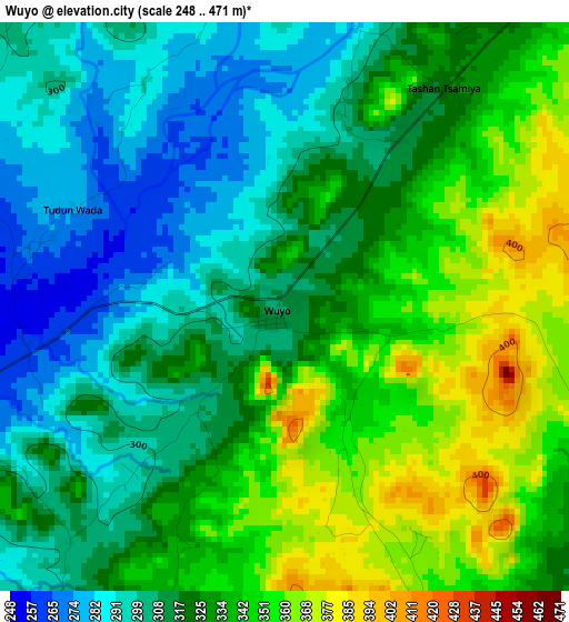
Below is the Elevation map of Wuyo, which displays elevation range with different colors. Scale of the first map is from 248 to 471 m (814 to 1545 ft) with average elevation of 324.2 meters (=1064 ft) [note 1]
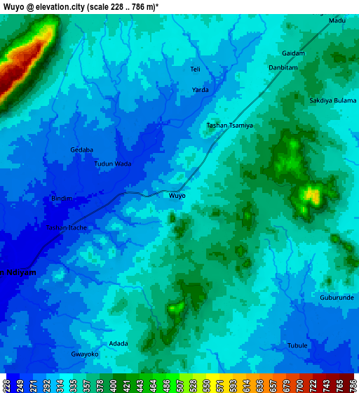
These maps also provides idea of topography and contour of this city, they are displayed at different zoom levels. More info about maps, scale and edge coordinates you can find below images.
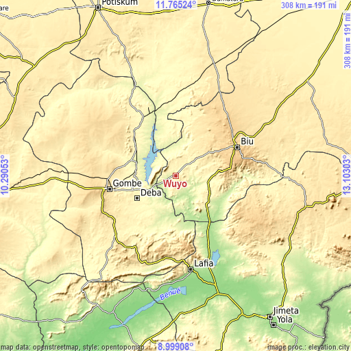
| \ | Map #1 | Map #2 | Topo.Map |
| Scale [m] | 248..471 m | 228..786 m | × |
| Scale [ft] | 814..1545 ft | 748..2579 ft | × |
| Average | 324.2 m = 1064 ft | 328.4 m = 1077 ft | × |
| Width | 9.61 km = 6 mi | 19.22 km = 11.9 mi | 307.6 km = 191.1 mi |
| Height | 9.61 km = 6 mi | 19.22 km = 11.9 mi | 307.6 km = 191.1 mi |
| ↑Max Latitude | 10.428442° | 10.471659° | 11.76524° |
| Latitude at center | 10.38522° | 10.38522° | 10.38522° |
| ↓Min Latitude | 10.341992° | 10.298757° | 8.99908° |
| ← Min Longitude | 11.652835° | 11.608889° | 10.29053° |
| Longitude center | 11.69678° | 11.69678° | 11.69678° |
| →Max Longitude | 11.740725° | 11.784671° | 13.10303° |
Nearby cities:
Cities around Wuyo sort by population:
• Gombe elevation 460 m
58.9 km,  259°
259°
• Biu 762 m
60 km,  65°
65°
• Deba 311 m
39 km,  240°
240°
• Shani 239 m
43.9 km,  115°
115°
• Hinna 221 m
23.4 km,  247°
247°
• Bara 289 m
61.3 km,  358°
358°
• Bajoga 294 m
59.4 km,  330°
330°
• Guyuk 217 m
58.9 km,  154°
154°
• Talasse 297 m
46.4 km,  182°
182°
• Mallam Sidi 326 m
45.1 km,  281°
281°
• Kwaya Kusar 359 m
20.7 km,  50°
50°
• Briyel 240 m
10.4 km, 246°
Multilingual:
 En español:
Wuyo elevación 312 m.
 En France:
Wuyo élévation 312 m.


Sources and notes:
- [note 1] Map square and city borders are not equal. Map elevation data is calculated only from area inside that square.
- [src 1] Elevation data from geonames database provided with same terms of usage.
- [src 2] The elevation map of Wuyo is generated using elevation data from NASA's 3 arcsec (90m) resolution SRTM data.
- [src 3] Base (background) map © OpenStreetMap contributors tiles are generated by Geofabrik and OpenTopoMap.
Copyright & License:
This Wuyo Elevation Map is licensed under CC BY-SA. You may reuse any part from this page, if you give a proper credit by linking to this URL:
 More info on terms of use page.