Izotepec elevation
Izotepec (Guerrero, General Heliodoro Castillo), Mexico elevation is 1364 meters and Izotepec elevation in feet is 4475 ft above sea level [src 1]. Izotepec is a populated place (feature code) with elevation that is 50 meters (164 ft) bigger than average city elevation in Mexico.
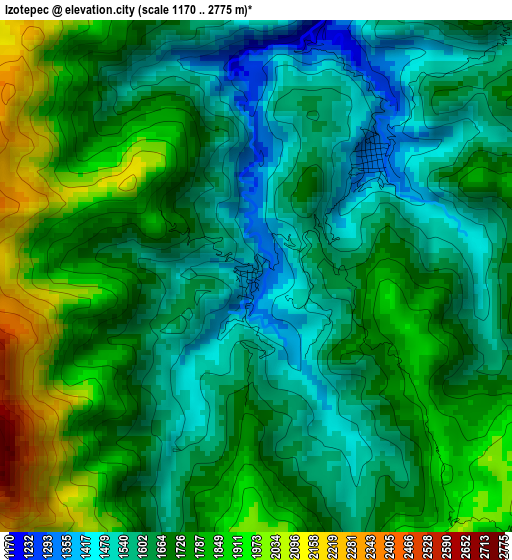
Below is the Elevation map of Izotepec, which displays elevation range with different colors. Scale of the first map is from 1170 to 2775 m (3839 to 9104 ft) with average elevation of 1694.2 meters (=5558 ft) [note 1]
These maps also provides idea of topography and contour of this city, they are displayed at different zoom levels. More info about maps, scale and edge coordinates you can find below images.
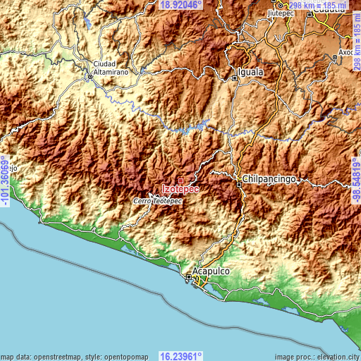
| \ | Map #1 | Topo.Map |
| Scale [m] | 1170..2775 m | × |
| Scale [ft] | 3839..9104 ft | × |
| Average | 1694.2 m = 5558 ft | × |
| Width | 9.32 km = 5.8 mi | 298.1 km = 185.2 mi |
| Height | 9.32 km = 5.8 mi | 298.1 km = 185.2 mi |
| ↑Max Latitude | 17.626887° | 18.92046° |
| Latitude at center | 17.585° | 17.585° |
| ↓Min Latitude | 17.543103° | 16.23961° |
| ← Min Longitude | -99.998385° | -101.36069° |
| Longitude center | -99.95444° | -99.95444° |
| →Max Longitude | -99.910495° | -98.54819° |
Nearby cities:
Cities around Izotepec sort by population:
• Chichihualco elevation 1148 m
30.6 km,  74°
74°
• Tlacotepec 1540 m
22.9 km,  353°
353°
• El Paraíso 792 m
39.5 km,  227°
227°
• Xochipala 1070 m
41.8 km,  52°
52°
• Yextla 1317 m
3 km,  44°
44°
• Jaleaca de Catalán 774 m
18.4 km,  146°
146°
• San Vicente 2160 m
29.8 km,  105°
105°
• Coacoyulillo 469 m
42.7 km,  130°
130°
• Carrizalillo 1520 m
39.1 km, 40°
• Pueblo Viejo 1825 m
18.1 km,  253°
253°
• El Fresno 1957 m
42.6 km, 113°
• San Cristóbal 882 m
34.4 km,  177°
177°
Multilingual:
 En español:
Izotepec elevación 1364 m.
 En France:
Izotepec élévation 1364 m.
 Auf Deutsch:
Izotepec höhe über dem Meeresspiegel ist 1364 m.

Sources and notes:
- [note 1] Map square and city borders are not equal. Map elevation data is calculated only from area inside that square.
- [src 1] Elevation data from geonames database provided with same terms of usage.
- [src 2] The elevation map of Izotepec is generated using elevation data from NASA's 3 arcsec (90m) resolution SRTM data.
- [src 3] Base (background) map © OpenStreetMap contributors tiles are generated by Geofabrik and OpenTopoMap.
Copyright & License:
This Izotepec Elevation Map is licensed under CC BY-SA. You may reuse any part from this page, if you give a proper credit by linking to this URL:
 More info on terms of use page.