Tlacotepec elevation
Tlacotepec (Guerrero, General Heliodoro Castillo), Mexico elevation is 1540 meters and Tlacotepec elevation in feet is 5052 ft above sea level [src 1]. Tlacotepec is a seat of a second-order administrative division (feature code) with elevation that is 226 meters (741 ft) bigger than average city elevation in Mexico.
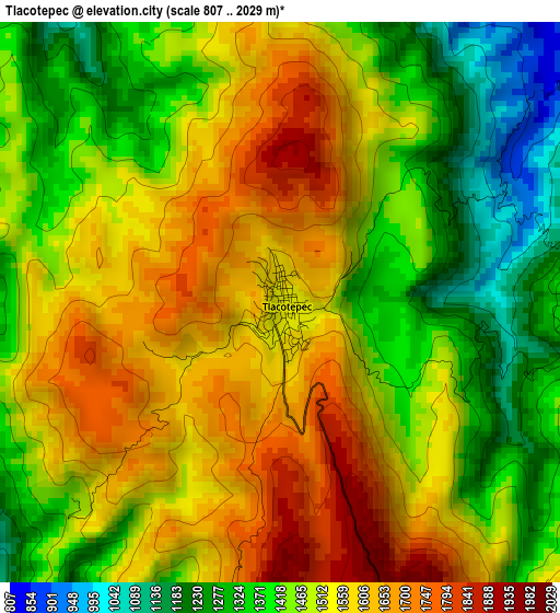
Below is the Elevation map of Tlacotepec, which displays elevation range with different colors. Scale of the first map is from 807 to 2029 m (2648 to 6657 ft) with average elevation of 1488.3 meters (=4883 ft) [note 1]
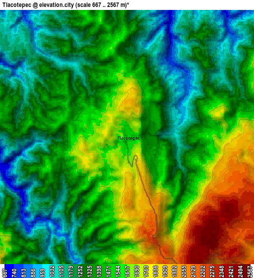
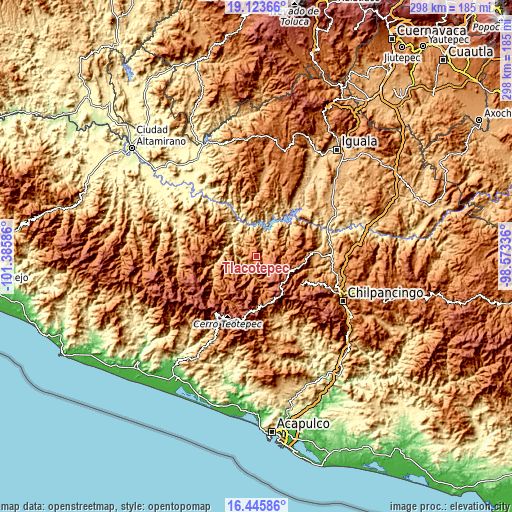
These maps also provides idea of topography and contour of this city, they are displayed at different zoom levels. More info about maps, scale and edge coordinates you can find below images.
| \ | Map #1 | Map #2 | Topo.Map |
| Scale [m] | 807..2029 m | 667..2567 m | × |
| Scale [ft] | 2648..6657 ft | 2188..8422 ft | × |
| Average | 1488.3 m = 4883 ft | 1437.5 m = 4716 ft | × |
| Width | 9.31 km = 5.8 mi | 18.61 km = 11.6 mi | 297.7 km = 185 mi |
| Height | 9.31 km = 5.8 mi | 18.61 km = 11.6 mi | 297.8 km = 185 mi |
| ↑Max Latitude | 17.831619° | 17.873448° | 19.12366° |
| Latitude at center | 17.78978° | 17.78978° | 17.78978° |
| ↓Min Latitude | 17.747931° | 17.706072° | 16.44586° |
| ← Min Longitude | -100.023555° | -100.067501° | -101.38586° |
| Longitude center | -99.97961° | -99.97961° | -99.97961° |
| →Max Longitude | -99.935665° | -99.891719° | -98.57336° |
Nearby cities:
Cities around Tlacotepec sort by population:
• Chichihualco elevation 1148 m
35.3 km,  114°
114°
• Apaxtla de Castrejón 1213 m
38.3 km,  7°
7°
• Mezcala 494 m
42.9 km,  68°
68°
• Xochipala 1070 m
36.1 km,  86°
86°
• Yextla 1317 m
21.2 km,  166°
166°
• Jaleaca de Catalán 774 m
40.2 km,  161°
161°
• Cuetzala del Progreso 1126 m
41.4 km,  22°
22°
• San Vicente 2160 m
43.8 km,  134°
134°
• Nuevo Balsas 487 m
35.7 km,  40°
40°
• Izotepec 1364 m
22.9 km, 173°
• Carrizalillo 1520 m
29.1 km,  76°
76°
• Pueblo Viejo 1825 m
31.5 km,  207°
207°
Multilingual:
 En español:
Tlacotepec elevación 1540 m.
 En France:
Tlacotepec élévation 1540 m.
 Auf Deutsch:
Tlacotepec höhe über dem Meeresspiegel ist 1540 m.

Sources and notes:
- [note 1] Map square and city borders are not equal. Map elevation data is calculated only from area inside that square.
- [src 1] Elevation data from geonames database provided with same terms of usage.
- [src 2] The elevation map of Tlacotepec is generated using elevation data from NASA's 3 arcsec (90m) resolution SRTM data.
- [src 3] Base (background) map © OpenStreetMap contributors tiles are generated by Geofabrik and OpenTopoMap.
Copyright & License:
This Tlacotepec Elevation Map is licensed under CC BY-SA. You may reuse any part from this page, if you give a proper credit by linking to this URL:
 More info on terms of use page.