Apaxtla de Castrejón elevation
Apaxtla de Castrejón (Guerrero, Apaxtla), Mexico elevation is 1213 meters and Apaxtla de Castrejón elevation in feet is 3980 ft above sea level [src 1]. Apaxtla de Castrejón is a seat of a second-order administrative division (feature code) with elevation that is 101 meters (331 ft) smaller than average city elevation in Mexico.
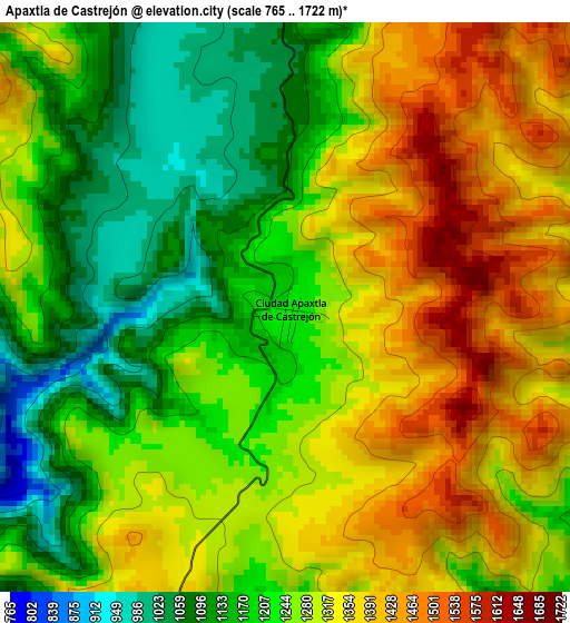
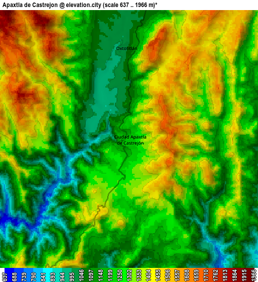
Below is the Elevation map of Apaxtla de Castrejón, which displays elevation range with different colors. Scale of the first map is from 765 to 1722 m (2510 to 5650 ft) with average elevation of 1266.9 meters (=4156 ft) [note 1]
These maps also provides idea of topography and contour of this city, they are displayed at different zoom levels. More info about maps, scale and edge coordinates you can find below images.
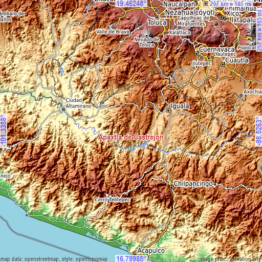
| \ | Map #1 | Map #2 | Topo.Map |
| Scale [m] | 765..1722 m | 637..1966 m | × |
| Scale [ft] | 2510..5650 ft | 2090..6450 ft | × |
| Average | 1266.9 m = 4156 ft | 1265.4 m = 4152 ft | × |
| Width | 9.29 km = 5.8 mi | 18.57 km = 11.5 mi | 297.2 km = 184.7 mi |
| Height | 9.29 km = 5.8 mi | 18.57 km = 11.5 mi | 297.2 km = 184.7 mi |
| ↑Max Latitude | 18.173028° | 18.214777° | 19.46248° |
| Latitude at center | 18.13127° | 18.13127° | 18.13127° |
| ↓Min Latitude | 18.089502° | 18.047724° | 16.78985° |
| ← Min Longitude | -99.976495° | -100.020441° | -101.3388° |
| Longitude center | -99.93255° | -99.93255° | -99.93255° |
| →Max Longitude | -99.888605° | -99.844659° | -98.5263° |
Nearby cities:
Cities around Apaxtla de Castrejón sort by population:
• Teloloapan elevation 1663 m
26.9 km,  13°
13°
• Cocula 616 m
31.1 km,  66°
66°
• Apipilulco 591 m
28.3 km,  76°
76°
• Cuetzala del Progreso 1126 m
10.6 km,  87°
87°
• Oxtotitlán 1074 m
6.5 km,  0°
0°
• Chilacachapa 1663 m
24 km,  48°
48°
• Nuevo Balsas 487 m
21.4 km,  120°
120°
• Colonia el Pedregal 1617 m
25.6 km,  18°
18°
• Acatempan 1657 m
21.4 km, 14°
• Tehuixtla 1165 m
20.6 km,  359°
359°
• Los Sauces 1617 m
18.2 km,  34°
34°
• Coatepec Costales 1291 m
32.1 km,  43°
43°
Multilingual:
 En español:
Ciudad Apaxtla de Castrejón elevación 1213 m.
 En France:
Apaxtla de Castrejón élévation 1213 m.
 Auf Deutsch:
Apaxtla de Castrejón höhe über dem Meeresspiegel ist 1213 m.
 На русском:
Apaxtla de Castrejón высота над уровнем моря 1213 м
Sources and notes:
- [note 1] Map square and city borders are not equal. Map elevation data is calculated only from area inside that square.
- [src 1] Elevation data from geonames database provided with same terms of usage.
- [src 2] The elevation map of Apaxtla de Castrejón is generated using elevation data from NASA's 3 arcsec (90m) resolution SRTM data.
- [src 3] Base (background) map © OpenStreetMap contributors tiles are generated by Geofabrik and OpenTopoMap.
Copyright & License:
This Apaxtla de Castrejón Elevation Map is licensed under CC BY-SA. You may reuse any part from this page, if you give a proper credit by linking to this URL:
 More info on terms of use page.