Cocula elevation
Cocula (Guerrero), Mexico elevation is 616 meters and Cocula elevation in feet is 2021 ft above sea level [src 1]. Cocula is a seat of a second-order administrative division (feature code) with elevation that is 698 meters (2290 ft) smaller than average city elevation in Mexico.
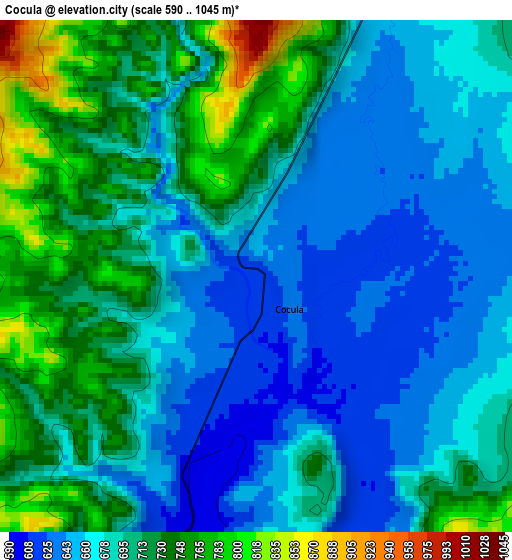
Below is the Elevation map of Cocula, which displays elevation range with different colors. Scale of the first map is from 590 to 1045 m (1936 to 3428 ft) with average elevation of 691.7 meters (=2269 ft) [note 1]
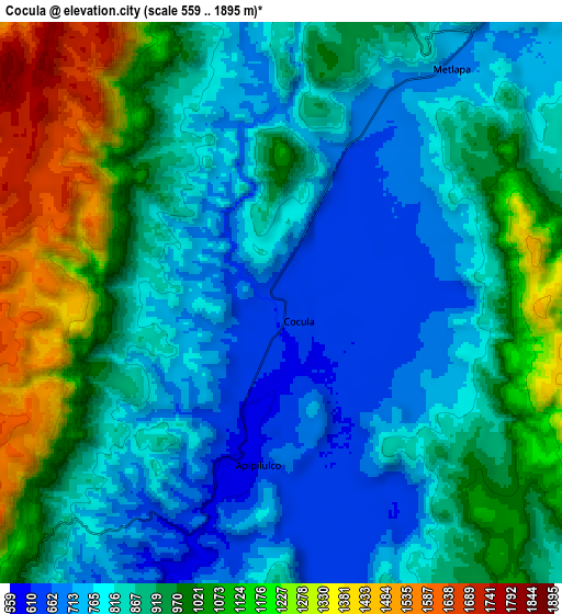
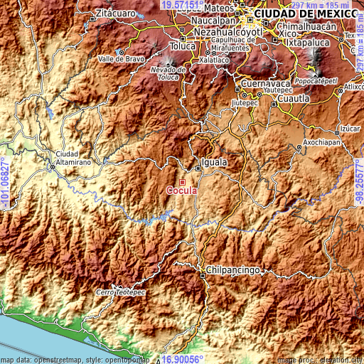
These maps also provides idea of topography and contour of this city, they are displayed at different zoom levels. More info about maps, scale and edge coordinates you can find below images.
| \ | Map #1 | Map #2 | Topo.Map |
| Scale [m] | 590..1045 m | 559..1895 m | × |
| Scale [ft] | 1936..3428 ft | 1834..6217 ft | × |
| Average | 691.7 m = 2269 ft | 910.1 m = 2986 ft | × |
| Width | 9.28 km = 5.8 mi | 18.56 km = 11.5 mi | 297 km = 184.5 mi |
| Height | 9.28 km = 5.8 mi | 18.56 km = 11.5 mi | 297 km = 184.5 mi |
| ↑Max Latitude | 18.282892° | 18.324614° | 19.57151° |
| Latitude at center | 18.24116° | 18.24116° | 18.24116° |
| ↓Min Latitude | 18.199418° | 18.157666° | 16.90056° |
| ← Min Longitude | -99.705965° | -99.749911° | -101.06827° |
| Longitude center | -99.66202° | -99.66202° | -99.66202° |
| →Max Longitude | -99.618075° | -99.574129° | -98.25577° |
Nearby cities:
Cities around Cocula sort by population:
• Iguala de la Independencia elevation 743 m
17.2 km,  47°
47°
• Coacoyula de Álvarez 873 m
18.6 km,  169°
169°
• Santa Teresa 841 m
16.4 km,  94°
94°
• Apipilulco 591 m
5.7 km,  190°
190°
• Chilacachapa 1663 m
11.1 km,  289°
289°
• Metlapa 700 m
9.5 km,  36°
36°
• Zacacoyuca 907 m
14.2 km, 85°
• Fermín Rabadán Cervantes 794 m
13 km, 50°
• Tecuexcontitlán (Tecoescontitlán) 798 m
14.1 km,  140°
140°
• Los Sauces 1617 m
18.5 km,  278°
278°
• Coatepec Costales 1291 m
12.6 km,  330°
330°
• Tonalapa del Sur 718 m
19.3 km,  145°
145°
Multilingual:
 En español:
Cocula elevación 616 m.
 En France:
Cocula élévation 616 m.


Sources and notes:
- [note 1] Map square and city borders are not equal. Map elevation data is calculated only from area inside that square.
- [src 1] Elevation data from geonames database provided with same terms of usage.
- [src 2] The elevation map of Cocula is generated using elevation data from NASA's 3 arcsec (90m) resolution SRTM data.
- [src 3] Base (background) map © OpenStreetMap contributors tiles are generated by Geofabrik and OpenTopoMap.
Copyright & License:
This Cocula Elevation Map is licensed under CC BY-SA. You may reuse any part from this page, if you give a proper credit by linking to this URL:
 More info on terms of use page.