Santa Teresa elevation
Santa Teresa (Guerrero, Iguala de la Independencia), Mexico elevation is 841 meters and Santa Teresa elevation in feet is 2759 ft above sea level [src 1]. Santa Teresa is a populated place (feature code) with elevation that is 473 meters (1552 ft) smaller than average city elevation in Mexico.
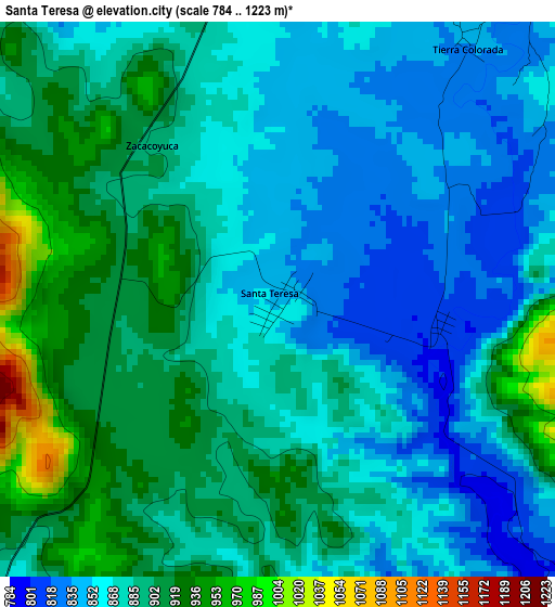
Below is the Elevation map of Santa Teresa, which displays elevation range with different colors. Scale of the first map is from 784 to 1223 m (2572 to 4012 ft) with average elevation of 881.5 meters (=2892 ft) [note 1]
These maps also provides idea of topography and contour of this city, they are displayed at different zoom levels. More info about maps, scale and edge coordinates you can find below images.
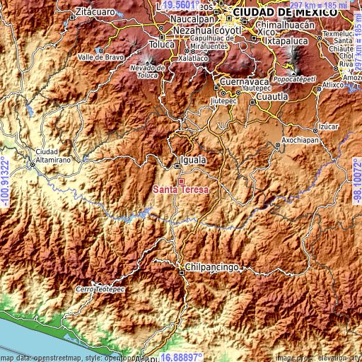
| \ | Map #1 | Topo.Map |
| Scale [m] | 784..1223 m | × |
| Scale [ft] | 2572..4012 ft | × |
| Average | 881.5 m = 2892 ft | × |
| Width | 9.28 km = 5.8 mi | 297 km = 184.5 mi |
| Height | 9.28 km = 5.8 mi | 297 km = 184.5 mi |
| ↑Max Latitude | 18.271395° | 19.5601° |
| Latitude at center | 18.22966° | 18.22966° |
| ↓Min Latitude | 18.187915° | 16.88897° |
| ← Min Longitude | -99.550915° | -100.91322° |
| Longitude center | -99.50697° | -99.50697° |
| →Max Longitude | -99.463025° | -98.10072° |
Nearby cities:
Cities around Santa Teresa sort by population:
• Iguala de la Independencia elevation 743 m
13.4 km,  344°
344°
• Tepecoacuilco de Trujano 845 m
7.9 km,  35°
35°
• Mayanalán 859 m
10.1 km,  128°
128°
• Tuxpan 762 m
13.6 km,  12°
12°
• Pololcingo 906 m
13.4 km,  64°
64°
• Metlapa 700 m
14 km,  309°
309°
• Zacacoyuca 907 m
3.2 km,  316°
316°
• Fermín Rabadán Cervantes 794 m
11.4 km,  326°
326°
• Tecuexcontitlán (Tecoescontitlán) 798 m
12.2 km,  217°
217°
• San Vicente Palapa 856 m
14.6 km, 43°
• Tierra Colorada 843 m
5.4 km,  34°
34°
• Tonalapa del Sur 718 m
15.7 km,  200°
200°
Multilingual:
 En español:
Santa Teresa elevación 841 m.
 En France:
Santa Teresa élévation 841 m.
 Auf Deutsch:
Santa Teresa höhe über dem Meeresspiegel ist 841 m.

Sources and notes:
- [note 1] Map square and city borders are not equal. Map elevation data is calculated only from area inside that square.
- [src 1] Elevation data from geonames database provided with same terms of usage.
- [src 2] The elevation map of Santa Teresa is generated using elevation data from NASA's 3 arcsec (90m) resolution SRTM data.
- [src 3] Base (background) map © OpenStreetMap contributors tiles are generated by Geofabrik and OpenTopoMap.
Copyright & License:
This Santa Teresa Elevation Map is licensed under CC BY-SA. You may reuse any part from this page, if you give a proper credit by linking to this URL:
 More info on terms of use page.