Teloloapan elevation
Teloloapan (Guerrero), Mexico elevation is 1663 meters and Teloloapan elevation in feet is 5456 ft above sea level [src 1]. Teloloapan is a seat of a second-order administrative division (feature code) with elevation that is 349 meters (1145 ft) bigger than average city elevation in Mexico.
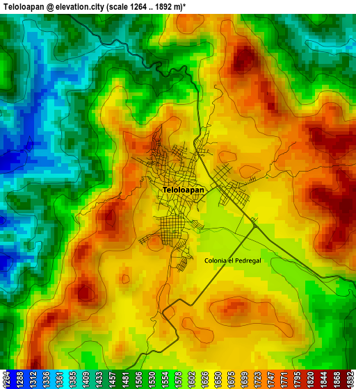
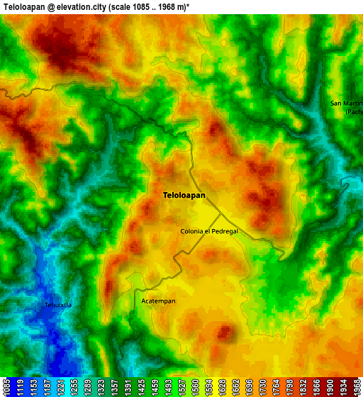
Below is the Elevation map of Teloloapan, which displays elevation range with different colors. Scale of the first map is from 1264 to 1892 m (4147 to 6207 ft) with average elevation of 1599.3 meters (=5247 ft) [note 1]
These maps also provides idea of topography and contour of this city, they are displayed at different zoom levels. More info about maps, scale and edge coordinates you can find below images.
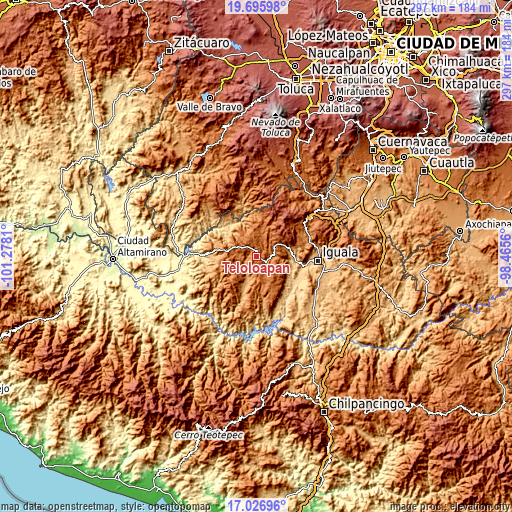
| \ | Map #1 | Map #2 | Topo.Map |
| Scale [m] | 1264..1892 m | 1085..1968 m | × |
| Scale [ft] | 4147..6207 ft | 3560..6457 ft | × |
| Average | 1599.3 m = 5247 ft | 1543.4 m = 5064 ft | × |
| Width | 9.27 km = 5.8 mi | 18.55 km = 11.5 mi | 296.8 km = 184.4 mi |
| Height | 9.27 km = 5.8 mi | 18.55 km = 11.5 mi | 296.8 km = 184.4 mi |
| ↑Max Latitude | 18.408332° | 18.450023° | 19.69598° |
| Latitude at center | 18.36663° | 18.36663° | 18.36663° |
| ↓Min Latitude | 18.324918° | 18.283196° | 17.02696° |
| ← Min Longitude | -99.915795° | -99.959741° | -101.2781° |
| Longitude center | -99.87185° | -99.87185° | -99.87185° |
| →Max Longitude | -99.827905° | -99.783959° | -98.4656° |
Nearby cities:
Cities around Teloloapan sort by population:
• Ixcateopan de Cuauhtémoc elevation 1827 m
17.2 km,  29°
29°
• Cuetzala del Progreso 1126 m
26.1 km,  170°
170°
• Oxtotitlán 1074 m
20.7 km,  198°
198°
• Chilacachapa 1663 m
15.5 km,  131°
131°
• Acapetlahuaya 1181 m
22 km,  285°
285°
• Colonia el Pedregal 1617 m
2.5 km,  139°
139°
• Acatempan 1657 m
5.5 km,  192°
192°
• Tehuixtla 1165 m
8.5 km,  229°
229°
• Los Sauces 1617 m
11.8 km,  160°
160°
• San Martín Pachivia (Pachivia) 1370 m
10 km,  62°
62°
• Coatepec Costales 1291 m
16.2 km,  100°
100°
• Ixcapuzalco 1778 m
16.3 km,  354°
354°
Multilingual:
 En español:
Teloloapan elevación 1663 m.
 En France:
Teloloapan élévation 1663 m.
 Auf Deutsch:
Teloloapan höhe über dem Meeresspiegel ist 1663 m.

Sources and notes:
- [note 1] Map square and city borders are not equal. Map elevation data is calculated only from area inside that square.
- [src 1] Elevation data from geonames database provided with same terms of usage.
- [src 2] The elevation map of Teloloapan is generated using elevation data from NASA's 3 arcsec (90m) resolution SRTM data.
- [src 3] Base (background) map © OpenStreetMap contributors tiles are generated by Geofabrik and OpenTopoMap.
Copyright & License:
This Teloloapan Elevation Map is licensed under CC BY-SA. You may reuse any part from this page, if you give a proper credit by linking to this URL:
 More info on terms of use page.