San Cristóbal elevation
San Cristóbal (Guerrero, Chilpancingo de los Bravo), Mexico elevation is 882 meters and San Cristóbal elevation in feet is 2894 ft above sea level [src 1]. San Cristóbal is a populated place (feature code) with elevation that is 432 meters (1417 ft) smaller than average city elevation in Mexico.
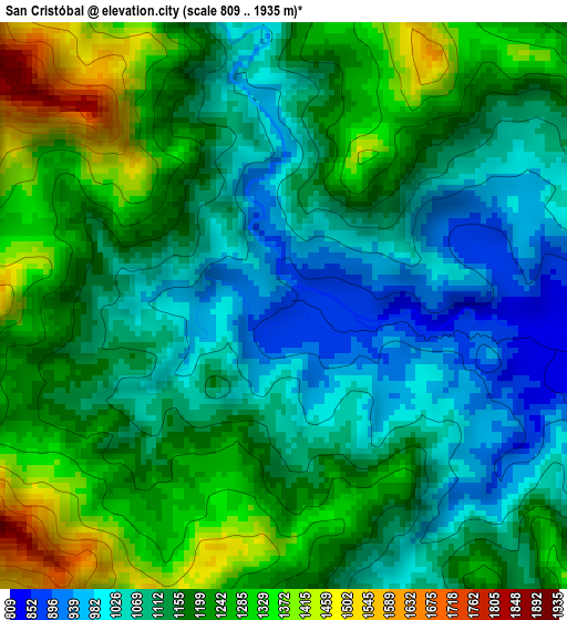
Below is the Elevation map of San Cristóbal, which displays elevation range with different colors. Scale of the first map is from 809 to 1935 m (2654 to 6348 ft) with average elevation of 1162.2 meters (=3813 ft) [note 1]
These maps also provides idea of topography and contour of this city, they are displayed at different zoom levels. More info about maps, scale and edge coordinates you can find below images.
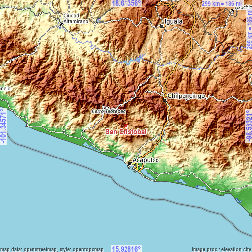
| \ | Map #1 | Topo.Map |
| Scale [m] | 809..1935 m | × |
| Scale [ft] | 2654..6348 ft | × |
| Average | 1162.2 m = 3813 ft | × |
| Width | 9.33 km = 5.8 mi | 298.6 km = 185.5 mi |
| Height | 9.33 km = 5.8 mi | 298.6 km = 185.5 mi |
| ↑Max Latitude | 17.317708° | 18.61356° |
| Latitude at center | 17.27575° | 17.27575° |
| ↓Min Latitude | 17.233782° | 15.92816° |
| ← Min Longitude | -99.983405° | -101.34571° |
| Longitude center | -99.93946° | -99.93946° |
| →Max Longitude | -99.895515° | -98.53321° |
Nearby cities:
Cities around San Cristóbal sort by population:
• Xaltianguis elevation 539 m
30.9 km,  129°
129°
• El Paraíso 792 m
31.6 km,  283°
283°
• Tepetixtla 408 m
20.1 km,  250°
250°
• Tixtlancingo 557 m
24.3 km,  185°
185°
• Jaleaca de Catalán 774 m
20.8 km,  24°
24°
• Aguas Blancas 35 m
29.7 km,  206°
206°
• Platanillo 612 m
23.7 km,  172°
172°
• Coacoyulillo 469 m
31.6 km,  78°
78°
• Pueblo Viejo 496 m
20.5 km, 194°
• Las Compuertas 900 m
11.5 km,  219°
219°
• Kilómetro 40 410 m
30.9 km,  144°
144°
• Ocotillo 713 m
27.5 km, 165°
Multilingual:
 En español:
San Cristóbal elevación 882 m.
 En France:
San Cristóbal élévation 882 m.
 Auf Deutsch:
San Cristóbal höhe über dem Meeresspiegel ist 882 m.

Sources and notes:
- [note 1] Map square and city borders are not equal. Map elevation data is calculated only from area inside that square.
- [src 1] Elevation data from geonames database provided with same terms of usage.
- [src 2] The elevation map of San Cristóbal is generated using elevation data from NASA's 3 arcsec (90m) resolution SRTM data.
- [src 3] Base (background) map © OpenStreetMap contributors tiles are generated by Geofabrik and OpenTopoMap.
Copyright & License:
This San Cristóbal Elevation Map is licensed under CC BY-SA. You may reuse any part from this page, if you give a proper credit by linking to this URL:
 More info on terms of use page.