Tepetixtla elevation
Tepetixtla (Guerrero, Coyuca de Benítez), Mexico elevation is 408 meters and Tepetixtla elevation in feet is 1339 ft above sea level [src 1]. Tepetixtla is a populated place (feature code) with elevation that is 906 meters (2972 ft) smaller than average city elevation in Mexico.
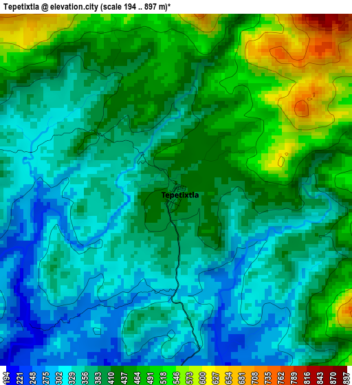
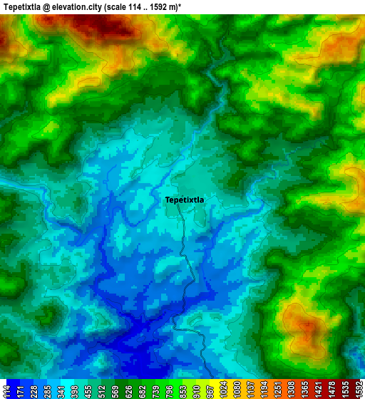
Below is the Elevation map of Tepetixtla, which displays elevation range with different colors. Scale of the first map is from 194 to 897 m (636 to 2943 ft) with average elevation of 401.3 meters (=1317 ft) [note 1]
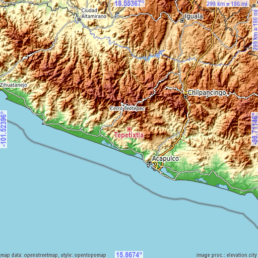
These maps also provides idea of topography and contour of this city, they are displayed at different zoom levels. More info about maps, scale and edge coordinates you can find below images.
| \ | Map #1 | Map #2 | Topo.Map |
| Scale [m] | 194..897 m | 114..1592 m | × |
| Scale [ft] | 636..2943 ft | 374..5223 ft | × |
| Average | 401.3 m = 1317 ft | 587 m = 1926 ft | × |
| Width | 9.33 km = 5.8 mi | 18.67 km = 11.6 mi | 298.7 km = 185.6 mi |
| Height | 9.33 km = 5.8 mi | 18.67 km = 11.6 mi | 298.7 km = 185.6 mi |
| ↑Max Latitude | 17.257382° | 17.299344° | 18.55367° |
| Latitude at center | 17.21541° | 17.21541° | 17.21541° |
| ↓Min Latitude | 17.173429° | 17.131438° | 15.8674° |
| ← Min Longitude | -100.161655° | -100.205601° | -101.52396° |
| Longitude center | -100.11771° | -100.11771° | -100.11771° |
| →Max Longitude | -100.073765° | -100.029819° | -98.71146° |
Nearby cities:
Cities around Tepetixtla sort by population:
• Coyuca de Benítez elevation 22 m
23.2 km,  171°
171°
• El Paraíso 792 m
18.5 km,  320°
320°
• Tixtlancingo 557 m
24.1 km,  136°
136°
• Zacualpan 19 m
26.2 km,  237°
237°
• Aguas Blancas 35 m
20.7 km,  163°
163°
• El Papayo 23 m
24.4 km,  214°
214°
• Pueblo Viejo 496 m
19 km,  133°
133°
• Las Lomas 14 m
26.1 km, 174°
• Cayaco 16 m
24.6 km,  220°
220°
• Las Compuertas 900 m
11.8 km,  100°
100°
• San Cristóbal 882 m
20.1 km,  70°
70°
• El Espinalillo 11 m
25.7 km,  182°
182°
Multilingual:
 En español:
Tepetixtla elevación 408 m.
 En France:
Tepetixtla élévation 408 m.
 Auf Deutsch:
Tepetixtla höhe über dem Meeresspiegel ist 408 m.

Sources and notes:
- [note 1] Map square and city borders are not equal. Map elevation data is calculated only from area inside that square.
- [src 1] Elevation data from geonames database provided with same terms of usage.
- [src 2] The elevation map of Tepetixtla is generated using elevation data from NASA's 3 arcsec (90m) resolution SRTM data.
- [src 3] Base (background) map © OpenStreetMap contributors tiles are generated by Geofabrik and OpenTopoMap.
Copyright & License:
This Tepetixtla Elevation Map is licensed under CC BY-SA. You may reuse any part from this page, if you give a proper credit by linking to this URL:
 More info on terms of use page.