Coyuca de Benítez elevation
Coyuca de Benítez (Guerrero), Mexico elevation is 22 meters and Coyuca de Benítez elevation in feet is 72 ft above sea level [src 1]. Coyuca de Benítez is a seat of a second-order administrative division (feature code) with elevation that is 1292 meters (4239 ft) smaller than average city elevation in Mexico.
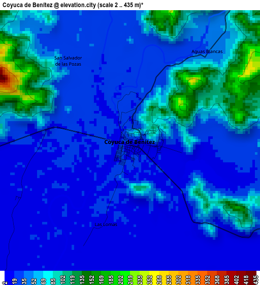
Below is the Elevation map of Coyuca de Benítez, which displays elevation range with different colors. Scale of the first map is from 2 to 435 m (7 to 1427 ft) with average elevation of 47.1 meters (=155 ft) [note 1]
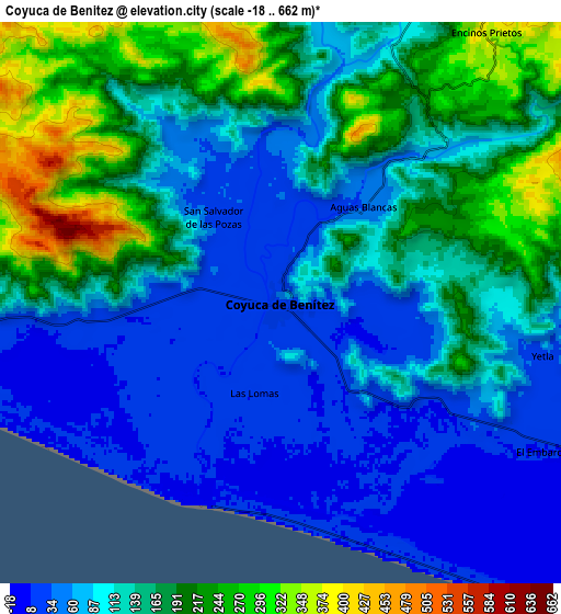
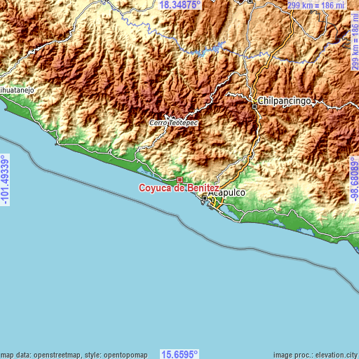
These maps also provides idea of topography and contour of this city, they are displayed at different zoom levels. More info about maps, scale and edge coordinates you can find below images.
| \ | Map #1 | Map #2 | Topo.Map |
| Scale [m] | 2..435 m | -18..662 m | × |
| Scale [ft] | 7..1427 ft | -59..2172 ft | × |
| Average | 47.1 m = 155 ft | 127.6 m = 419 ft | × |
| Width | 9.34 km = 5.8 mi | 18.69 km = 11.6 mi | 299 km = 185.8 mi |
| Height | 9.35 km = 5.8 mi | 18.69 km = 11.6 mi | 299 km = 185.8 mi |
| ↑Max Latitude | 17.050968° | 17.092977° | 18.34875° |
| Latitude at center | 17.00895° | 17.00895° | 17.00895° |
| ↓Min Latitude | 16.966922° | 16.924885° | 15.6595° |
| ← Min Longitude | -100.131085° | -100.175031° | -101.49339° |
| Longitude center | -100.08714° | -100.08714° | -100.08714° |
| →Max Longitude | -100.043195° | -99.999249° | -98.68089° |
Nearby cities:
Cities around Coyuca de Benítez sort by population:
• Bajos del Ejido elevation 15 m
13.4 km,  113°
113°
• Tixtlancingo 557 m
14.4 km,  67°
67°
• Aguas Blancas 35 m
4 km,  39°
39°
• Pueblo Viejo 496 m
14.4 km,  46°
46°
• Valle del Río 31 m
16.4 km,  102°
102°
• El Conchero 12 m
15.2 km,  119°
119°
• El Embarcadero 11 m
10.4 km, 118°
• Yetla 28 m
9.1 km, 100°
• Las Lomas 14 m
3.1 km,  195°
195°
• Los Mogotes 11 m
7.6 km,  171°
171°
• Colonia Luces en el Mar 11 m
12.4 km,  141°
141°
• El Espinalillo 11 m
5 km,  237°
237°
Multilingual:
 En español:
Coyuca de Benítez elevación 22 m.
 En France:
Coyuca de Benítez élévation 22 m.
 Auf Deutsch:
Coyuca de Benítez höhe über dem Meeresspiegel ist 22 m.

Sources and notes:
- [note 1] Map square and city borders are not equal. Map elevation data is calculated only from area inside that square.
- [src 1] Elevation data from geonames database provided with same terms of usage.
- [src 2] The elevation map of Coyuca de Benítez is generated using elevation data from NASA's 3 arcsec (90m) resolution SRTM data.
- [src 3] Base (background) map © OpenStreetMap contributors tiles are generated by Geofabrik and OpenTopoMap.
Copyright & License:
This Coyuca de Benítez Elevation Map is licensed under CC BY-SA. You may reuse any part from this page, if you give a proper credit by linking to this URL:
 More info on terms of use page.