San Andrés Cohamiata elevation
San Andrés Cohamiata (Jalisco, Mezquitic), Mexico elevation is 1951 meters and San Andrés Cohamiata elevation in feet is 6401 ft above sea level [src 1]. San Andrés Cohamiata is a populated place (feature code) with elevation that is 637 meters (2090 ft) bigger than average city elevation in Mexico.
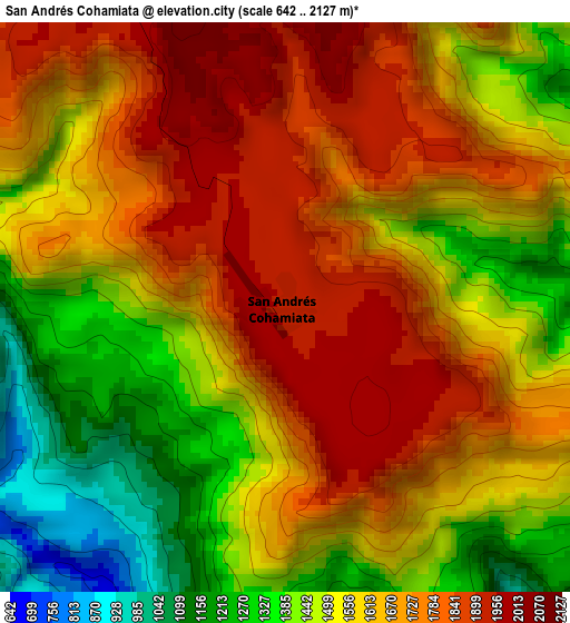
Below is the Elevation map of San Andrés Cohamiata, which displays elevation range with different colors. Scale of the first map is from 642 to 2127 m (2106 to 6978 ft) with average elevation of 1594 meters (=5230 ft) [note 1]
These maps also provides idea of topography and contour of this city, they are displayed at different zoom levels. More info about maps, scale and edge coordinates you can find below images.
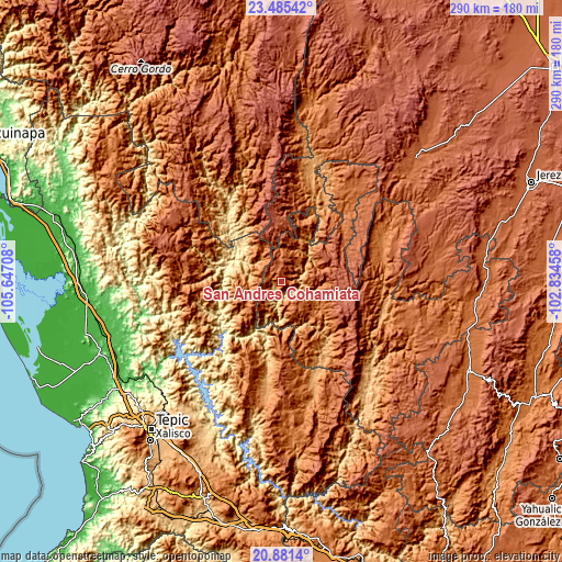
| \ | Map #1 | Topo.Map |
| Scale [m] | 642..2127 m | × |
| Scale [ft] | 2106..6978 ft | × |
| Average | 1594 m = 5230 ft | × |
| Width | 9.05 km = 5.6 mi | 289.5 km = 179.9 mi |
| Height | 9.05 km = 5.6 mi | 289.6 km = 179.9 mi |
| ↑Max Latitude | 22.230125° | 23.48542° |
| Latitude at center | 22.18944° | 22.18944° |
| ↓Min Latitude | 22.148743° | 20.8814° |
| ← Min Longitude | -104.284775° | -105.64708° |
| Longitude center | -104.24083° | -104.24083° |
| →Max Longitude | -104.196885° | -102.83458° |
Nearby cities:
Cities around San Andrés Cohamiata sort by population:
• Huejuquilla el Alto elevation 1742 m
60 km,  36°
36°
• Monte Escobedo 2208 m
70.4 km,  79°
79°
• Villa Guerrero 1774 m
70.4 km,  108°
108°
• Jesús María 426 m
29.3 km,  283°
283°
• Mezquitic 1357 m
57.3 km,  67°
67°
• San Martín de Bolaños 813 m
71.6 km,  141°
141°
• Puente de Camotlán 1142 m
57 km,  163°
163°
• Mesa del Nayar 1392 m
42.6 km,  274°
274°
• Santa Teresa 2120 m
63.9 km,  302°
302°
• Tuxpan de Bolaños 1134 m
42.1 km,  146°
146°
• Huajimic 1132 m
56.8 km,  187°
187°
• Chimaltitán 857 m
65.8 km,  133°
133°
Multilingual:
 En español:
San Andrés Cohamiata elevación 1951 m.
 En France:
San Andrés Cohamiata élévation 1951 m.
 Auf Deutsch:
San Andrés Cohamiata höhe über dem Meeresspiegel ist 1951 m.
 На русском:
San Andrés Cohamiata высота над уровнем моря 1951 м
Sources and notes:
- [note 1] Map square and city borders are not equal. Map elevation data is calculated only from area inside that square.
- [src 1] Elevation data from geonames database provided with same terms of usage.
- [src 2] The elevation map of San Andrés Cohamiata is generated using elevation data from NASA's 3 arcsec (90m) resolution SRTM data.
- [src 3] Base (background) map © OpenStreetMap contributors tiles are generated by Geofabrik and OpenTopoMap.
Copyright & License:
This San Andrés Cohamiata Elevation Map is licensed under CC BY-SA. You may reuse any part from this page, if you give a proper credit by linking to this URL:
 More info on terms of use page.