Mesa del Nayar elevation
Mesa del Nayar (Nayarit, Del Nayar), Mexico elevation is 1392 meters and Mesa del Nayar elevation in feet is 4567 ft above sea level [src 1]. Mesa del Nayar is a populated place (feature code) with elevation that is 78 meters (256 ft) bigger than average city elevation in Mexico.
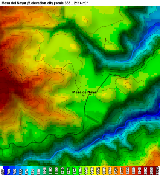
Below is the Elevation map of Mesa del Nayar, which displays elevation range with different colors. Scale of the first map is from 653 to 2114 m (2142 to 6936 ft) with average elevation of 1347.5 meters (=4421 ft) [note 1]
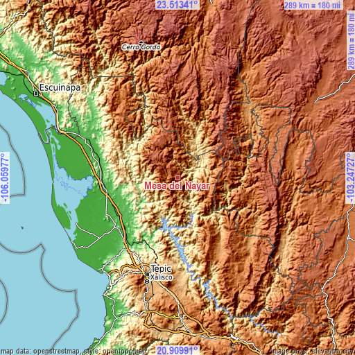
These maps also provides idea of topography and contour of this city, they are displayed at different zoom levels. More info about maps, scale and edge coordinates you can find below images.
| \ | Map #1 | Topo.Map |
| Scale [m] | 653..2114 m | × |
| Scale [ft] | 2142..6936 ft | × |
| Average | 1347.5 m = 4421 ft | × |
| Width | 9.05 km = 5.6 mi | 289.5 km = 179.9 mi |
| Height | 9.05 km = 5.6 mi | 289.5 km = 179.9 mi |
| ↑Max Latitude | 22.258377° | 23.51341° |
| Latitude at center | 22.2177° | 22.2177° |
| ↓Min Latitude | 22.177012° | 20.90991° |
| ← Min Longitude | -104.697465° | -106.05977° |
| Longitude center | -104.65352° | -104.65352° |
| →Max Longitude | -104.609575° | -103.24727° |
Nearby cities:
Cities around Mesa del Nayar sort by population:
• Ruíz elevation 33 m
58.6 km,  239°
239°
• Yago 32 m
60 km,  224°
224°
• Rosamorada 23 m
57.9 km,  259°
259°
• Jesús María 426 m
14.4 km,  75°
75°
• Chilapa 21 m
62.9 km,  250°
250°
• Atonalisco 375 m
64.3 km,  197°
197°
• Santa Teresa 2120 m
33.2 km,  339°
339°
• El Capomal 35 m
64 km,  228°
228°
• El Venado 60 m
47 km, 229°
• San Juan Bautista 89 m
46.4 km, 259°
• San Andrés Cohamiata 1951 m
42.6 km,  94°
94°
• El Vado de San Pedro 24 m
62 km, 241°
Multilingual:
 En español:
Mesa del Nayar elevación 1392 m.
 En France:
Mesa del Nayar élévation 1392 m.
 Auf Deutsch:
Mesa del Nayar höhe über dem Meeresspiegel ist 1392 m.

Sources and notes:
- [note 1] Map square and city borders are not equal. Map elevation data is calculated only from area inside that square.
- [src 1] Elevation data from geonames database provided with same terms of usage.
- [src 2] The elevation map of Mesa del Nayar is generated using elevation data from NASA's 3 arcsec (90m) resolution SRTM data.
- [src 3] Base (background) map © OpenStreetMap contributors tiles are generated by Geofabrik and OpenTopoMap.
Copyright & License:
This Mesa del Nayar Elevation Map is licensed under CC BY-SA. You may reuse any part from this page, if you give a proper credit by linking to this URL:
 More info on terms of use page.