Suchilapan del Río elevation
Suchilapan del Río (Veracruz, Jesús Carranza), Mexico elevation is 42 meters and Suchilapan del Río elevation in feet is 138 ft above sea level [src 1]. Suchilapan del Río is a populated place (feature code) with elevation that is 1272 meters (4173 ft) smaller than average city elevation in Mexico.
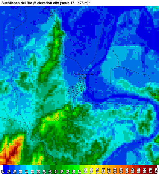
Below is the Elevation map of Suchilapan del Río, which displays elevation range with different colors. Scale of the first map is from 17 to 176 m (56 to 577 ft) with average elevation of 44.2 meters (=145 ft) [note 1]
These maps also provides idea of topography and contour of this city, they are displayed at different zoom levels. More info about maps, scale and edge coordinates you can find below images.
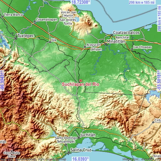
| \ | Map #1 | Topo.Map |
| Scale [m] | 17..176 m | × |
| Scale [ft] | 56..577 ft | × |
| Average | 44.2 m = 145 ft | × |
| Width | 9.33 km = 5.8 mi | 298.4 km = 185.4 mi |
| Height | 9.33 km = 5.8 mi | 298.4 km = 185.4 mi |
| ↑Max Latitude | 17.428043° | 18.72308° |
| Latitude at center | 17.38611° | 17.38611° |
| ↓Min Latitude | 17.344168° | 16.0393° |
| ← Min Longitude | -95.032005° | -96.39431° |
| Longitude center | -94.98806° | -94.98806° |
| →Max Longitude | -94.944115° | -93.58181° |
Nearby cities:
Cities around Suchilapan del Río sort by population:
• Jesús Carranza elevation 41 m
6.8 km,  323°
323°
• Palomares 118 m
28.7 km,  196°
196°
• Donaji 77 m
18.7 km, 201°
• Cuauhtémoc 106 m
33.5 km,  160°
160°
• El Porvenir 99 m
30.1 km,  289°
289°
• Santa Ana 133 m
38.3 km, 195°
• Vicente Guerrero 47 m
31 km,  66°
66°
• Los Ángeles 46 m
18.8 km,  272°
272°
• Medias Aguas 63 m
31.6 km,  352°
352°
• Venustiano Carranza (Peña Blanca) 15 m
37.7 km,  41°
41°
• El Paraíso 91 m
21.8 km,  311°
311°
• Paso Real de Sarabia 112 m
35.3 km,  190°
190°
Multilingual:
 En español:
Suchilapan del Río elevación 42 m.
 En France:
Suchilapan del Río élévation 42 m.
 Auf Deutsch:
Suchilapan del Río höhe über dem Meeresspiegel ist 42 m.

Sources and notes:
- [note 1] Map square and city borders are not equal. Map elevation data is calculated only from area inside that square.
- [src 1] Elevation data from geonames database provided with same terms of usage.
- [src 2] The elevation map of Suchilapan del Río is generated using elevation data from NASA's 3 arcsec (90m) resolution SRTM data.
- [src 3] Base (background) map © OpenStreetMap contributors tiles are generated by Geofabrik and OpenTopoMap.
Copyright & License:
This Suchilapan del Río Elevation Map is licensed under CC BY-SA. You may reuse any part from this page, if you give a proper credit by linking to this URL:
 More info on terms of use page.