El Durazno elevation
El Durazno (Michoacán, Morelia), Mexico elevation is 2134 meters and El Durazno elevation in feet is 7001 ft above sea level [src 1]. El Durazno is a populated place (feature code) with elevation that is 820 meters (2690 ft) bigger than average city elevation in Mexico.
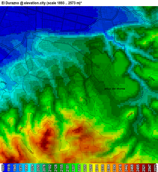
Below is the Elevation map of El Durazno, which displays elevation range with different colors. Scale of the first map is from 1893 to 2573 m (6211 to 8442 ft) with average elevation of 2126.9 meters (=6978 ft) [note 1]
These maps also provides idea of topography and contour of this city, they are displayed at different zoom levels. More info about maps, scale and edge coordinates you can find below images.
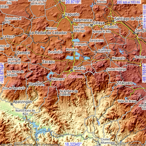
| \ | Map #1 | Topo.Map |
| Scale [m] | 1893..2573 m | × |
| Scale [ft] | 6211..8442 ft | × |
| Average | 2126.9 m = 6978 ft | × |
| Width | 9.2 km = 5.7 mi | 294.5 km = 183 mi |
| Height | 9.2 km = 5.7 mi | 294.5 km = 183 mi |
| ↑Max Latitude | 19.69452° | 20.9719° |
| Latitude at center | 19.65314° | 19.65314° |
| ↓Min Latitude | 19.611749° | 18.32345° |
| ← Min Longitude | -101.215335° | -102.57764° |
| Longitude center | -101.17139° | -101.17139° |
| →Max Longitude | -101.127445° | -99.76514° |
Nearby cities:
Cities around El Durazno sort by population:
• Morelia elevation 1917 m
5.5 km,  345°
345°
• Morelos 1950 m
7.1 km,  266°
266°
• La Aldea 1908 m
10.7 km,  20°
20°
• Jesús del Monte 2154 m
2 km,  95°
95°
• Real Hacienda (Metrópolis) 1896 m
11.2 km, 346°
• San Antonio 1911 m
10.2 km,  278°
278°
• Puerto de Buenavista (Lázaro Cárdenas) 2037 m
6 km,  49°
49°
• San Juanito Itzícuaro 1903 m
9.1 km,  286°
286°
• Atapaneo 1896 m
11.2 km,  31°
31°
• Jaripeo 2062 m
9.5 km,  71°
71°
• Montaña Monarca (Punta Altozano) 2127 m
1 km,  36°
36°
• La Mintzita (Piedra Dura) 1902 m
11.1 km, 269°
Multilingual:
 En español:
El Durazno elevación 2134 m.
 En France:
El Durazno élévation 2134 m.
 Auf Deutsch:
El Durazno höhe über dem Meeresspiegel ist 2134 m.

Sources and notes:
- [note 1] Map square and city borders are not equal. Map elevation data is calculated only from area inside that square.
- [src 1] Elevation data from geonames database provided with same terms of usage.
- [src 2] The elevation map of El Durazno is generated using elevation data from NASA's 3 arcsec (90m) resolution SRTM data.
- [src 3] Base (background) map © OpenStreetMap contributors tiles are generated by Geofabrik and OpenTopoMap.
Copyright & License:
This El Durazno Elevation Map is licensed under CC BY-SA. You may reuse any part from this page, if you give a proper credit by linking to this URL:
 More info on terms of use page.