San Antonio elevation
San Antonio (Michoacán, Morelia), Mexico elevation is 1911 meters and San Antonio elevation in feet is 6270 ft above sea level [src 1]. San Antonio is a populated place (feature code) with elevation that is 597 meters (1959 ft) bigger than average city elevation in Mexico.
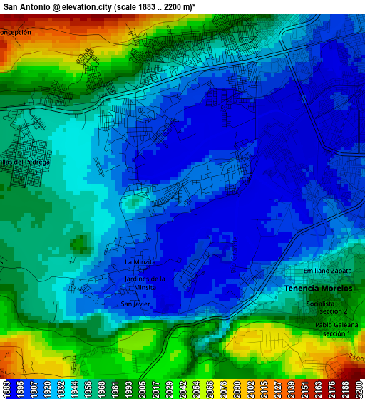
Below is the Elevation map of San Antonio, which displays elevation range with different colors. Scale of the first map is from 1883 to 2200 m (6178 to 7218 ft) with average elevation of 1955.1 meters (=6414 ft) [note 1]
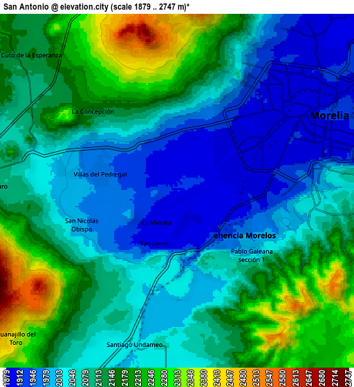
These maps also provides idea of topography and contour of this city, they are displayed at different zoom levels. More info about maps, scale and edge coordinates you can find below images.
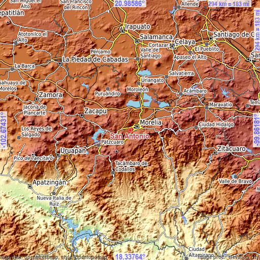
| \ | Map #1 | Map #2 | Topo.Map |
| Scale [m] | 1883..2200 m | 1879..2747 m | × |
| Scale [ft] | 6178..7218 ft | 6165..9012 ft | × |
| Average | 1955.1 m = 6414 ft | 2093.1 m = 6867 ft | × |
| Width | 9.2 km = 5.7 mi | 18.4 km = 11.4 mi | 294.5 km = 183 mi |
| Height | 9.2 km = 5.7 mi | 18.4 km = 11.4 mi | 294.5 km = 183 mi |
| ↑Max Latitude | 19.708596° | 19.749962° | 20.98586° |
| Latitude at center | 19.66722° | 19.66722° | 19.66722° |
| ↓Min Latitude | 19.625833° | 19.584435° | 18.33764° |
| ← Min Longitude | -101.312005° | -101.355951° | -102.67431° |
| Longitude center | -101.26806° | -101.26806° | -101.26806° |
| →Max Longitude | -101.224115° | -101.180169° | -99.86181° |
Nearby cities:
Cities around San Antonio sort by population:
• Morelia elevation 1917 m
9.5 km,  66°
66°
• Morelos 1950 m
3.7 km,  123°
123°
• Conjunto Habitacional Villas del Pedregal 1949 m
4.1 km,  296°
296°
• Villa Magna 2015 m
6.4 km,  286°
286°
• Villas de la Loma 1987 m
4.1 km,  307°
307°
• San Nicolás Obispo 1988 m
5.2 km,  252°
252°
• Lomas de la Maestranza 2045 m
6.9 km, 289°
• San Juanito Itzícuaro 1903 m
1.7 km,  56°
56°
• Santiago Undameo 2045 m
8.2 km,  192°
192°
• Tacicuaro 2085 m
9.6 km,  271°
271°
• San Lorenzo Itzícuaro 1898 m
1.7 km, 308°
• La Mintzita (Piedra Dura) 1902 m
2 km,  210°
210°
Multilingual:
 En español:
San Antonio elevación 1911 m.
 En France:
San Antonio élévation 1911 m.
 Auf Deutsch:
San Antonio höhe über dem Meeresspiegel ist 1911 m.

Sources and notes:
- [note 1] Map square and city borders are not equal. Map elevation data is calculated only from area inside that square.
- [src 1] Elevation data from geonames database provided with same terms of usage.
- [src 2] The elevation map of San Antonio is generated using elevation data from NASA's 3 arcsec (90m) resolution SRTM data.
- [src 3] Base (background) map © OpenStreetMap contributors tiles are generated by Geofabrik and OpenTopoMap.
Copyright & License:
This San Antonio Elevation Map is licensed under CC BY-SA. You may reuse any part from this page, if you give a proper credit by linking to this URL:
 More info on terms of use page.