Morelia elevation
Morelia (Michoacán), Mexico elevation is 1917 meters and Morelia elevation in feet is 6289 ft above sea level [src 1]. Morelia is a seat of a first-order administrative division (feature code) with elevation that is 603 meters (1978 ft) bigger than average city elevation in Mexico.
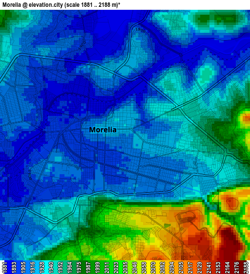
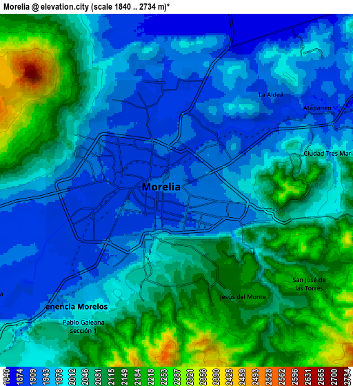
Below is the Elevation map of Morelia, which displays elevation range with different colors. Scale of the first map is from 1881 to 2188 m (6171 to 7178 ft) with average elevation of 1941.9 meters (=6371 ft) [note 1]
These maps also provides idea of topography and contour of this city, they are displayed at different zoom levels. More info about maps, scale and edge coordinates you can find below images.
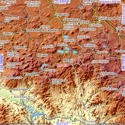
| \ | Map #1 | Map #2 | Topo.Map |
| Scale [m] | 1881..2188 m | 1840..2734 m | × |
| Scale [ft] | 6171..7178 ft | 6037..8970 ft | × |
| Average | 1941.9 m = 6371 ft | 2031.1 m = 6664 ft | × |
| Width | 9.2 km = 5.7 mi | 18.4 km = 11.4 mi | 294.4 km = 182.9 mi |
| Height | 9.2 km = 5.7 mi | 18.4 km = 11.4 mi | 294.4 km = 182.9 mi |
| ↑Max Latitude | 19.742148° | 19.783505° | 21.01914° |
| Latitude at center | 19.70078° | 19.70078° | 19.70078° |
| ↓Min Latitude | 19.659402° | 19.618013° | 18.37147° |
| ← Min Longitude | -101.228375° | -101.272321° | -102.59068° |
| Longitude center | -101.18443° | -101.18443° | -101.18443° |
| →Max Longitude | -101.140485° | -101.096539° | -99.77818° |
Nearby cities:
Cities around Morelia sort by population:
• La Aldea elevation 1908 m
7 km,  47°
47°
• Fraccionamiento Galaxia Tarímbaro 1922 m
6.9 km,  351°
351°
• Fraccionamiento Metrópolis II 1908 m
6.5 km,  341°
341°
• Jesús del Monte 2154 m
6.4 km,  148°
148°
• Real Hacienda (Metrópolis) 1896 m
5.7 km, 346°
• Puerto de Buenavista (Lázaro Cárdenas) 2037 m
6.2 km,  103°
103°
• San Juanito Itzícuaro 1903 m
7.9 km,  249°
249°
• San Bernabé de las Canteras 1911 m
7.6 km,  16°
16°
• El Durazno 2134 m
5.5 km,  165°
165°
• Conjunto Habitacional el Trébol 1863 m
8 km, 22°
• Montaña Monarca (Punta Altozano) 2127 m
4.9 km,  156°
156°
• Fraccionamiento Privadas del Sol 1899 m
5.8 km, 352°
Multilingual:
 En español:
Morelia elevación 1917 m.
 En France:
Morelia élévation 1917 m.
 Auf Deutsch:
Morelia höhe über dem Meeresspiegel ist 1917 m.

Sources and notes:
- [note 1] Map square and city borders are not equal. Map elevation data is calculated only from area inside that square.
- [src 1] Elevation data from geonames database provided with same terms of usage.
- [src 2] The elevation map of Morelia is generated using elevation data from NASA's 3 arcsec (90m) resolution SRTM data.
- [src 3] Base (background) map © OpenStreetMap contributors tiles are generated by Geofabrik and OpenTopoMap.
Copyright & License:
This Morelia Elevation Map is licensed under CC BY-SA. You may reuse any part from this page, if you give a proper credit by linking to this URL:
 More info on terms of use page.