Los Desmontes elevation
Los Desmontes (Guanajuato, Acámbaro), Mexico elevation is 2054 meters and Los Desmontes elevation in feet is 6739 ft above sea level [src 1]. Los Desmontes is a populated place (feature code) with elevation that is 740 meters (2428 ft) bigger than average city elevation in Mexico.
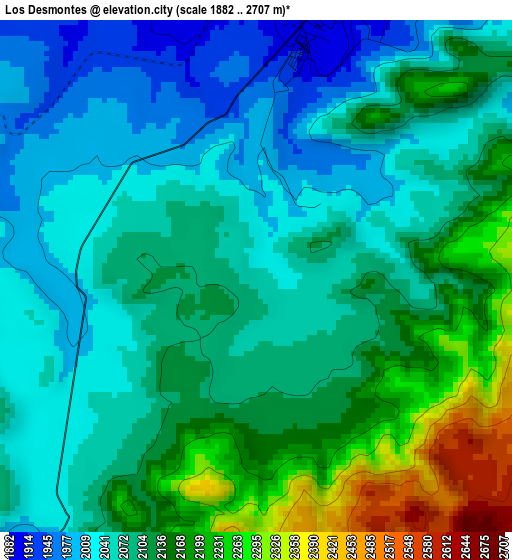
Below is the Elevation map of Los Desmontes, which displays elevation range with different colors. Scale of the first map is from 1882 to 2707 m (6175 to 8881 ft) with average elevation of 2102.5 meters (=6898 ft) [note 1]
These maps also provides idea of topography and contour of this city, they are displayed at different zoom levels. More info about maps, scale and edge coordinates you can find below images.
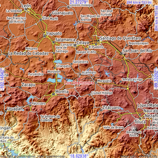
| \ | Map #1 | Topo.Map |
| Scale [m] | 1882..2707 m | × |
| Scale [ft] | 6175..8881 ft | × |
| Average | 2102.5 m = 6898 ft | × |
| Width | 9.19 km = 5.7 mi | 293.9 km = 182.6 mi |
| Height | 9.19 km = 5.7 mi | 293.9 km = 182.6 mi |
| ↑Max Latitude | 19.997921° | 21.27279° |
| Latitude at center | 19.95662° | 19.95662° |
| ↓Min Latitude | 19.915308° | 18.62938° |
| ← Min Longitude | -100.783115° | -102.14542° |
| Longitude center | -100.73917° | -100.73917° |
| →Max Longitude | -100.695225° | -99.33292° |
Nearby cities:
Cities around Los Desmontes sort by population:
• Acámbaro elevation 1861 m
8.4 km,  12°
12°
• Zinapécuaro 1886 m
14.2 km,  221°
221°
• Santiago Puriatzícuaro 2487 m
17.7 km,  117°
117°
• Ucareo 2553 m
8.5 km,  139°
139°
• Bocaneo (San Pedro) 1879 m
15.5 km,  211°
211°
• José María Morelos (La Yegüería) 1849 m
17.9 km,  234°
234°
• Araró 1852 m
10.3 km,  240°
240°
• Santa Clara del Tule 1911 m
17.4 km, 211°
• Chamácuaro 1863 m
18.9 km,  330°
330°
• Huajúmbaro 2564 m
17.1 km, 124°
• San Juan Jaripeo 1885 m
5.9 km,  337°
337°
• San Diego de Alcalá 2015 m
15.4 km,  302°
302°
Multilingual:
 En español:
Los Desmontes elevación 2054 m.
 En France:
Los Desmontes élévation 2054 m.
 Auf Deutsch:
Los Desmontes höhe über dem Meeresspiegel ist 2054 m.

Sources and notes:
- [note 1] Map square and city borders are not equal. Map elevation data is calculated only from area inside that square.
- [src 1] Elevation data from geonames database provided with same terms of usage.
- [src 2] The elevation map of Los Desmontes is generated using elevation data from NASA's 3 arcsec (90m) resolution SRTM data.
- [src 3] Base (background) map © OpenStreetMap contributors tiles are generated by Geofabrik and OpenTopoMap.
Copyright & License:
This Los Desmontes Elevation Map is licensed under CC BY-SA. You may reuse any part from this page, if you give a proper credit by linking to this URL:
 More info on terms of use page.