San Diego de Alcalá elevation
San Diego de Alcalá (Guanajuato, Acámbaro), Mexico elevation is 2015 meters and San Diego de Alcalá elevation in feet is 6611 ft above sea level [src 1]. San Diego de Alcalá is a populated place (feature code) with elevation that is 701 meters (2300 ft) bigger than average city elevation in Mexico.
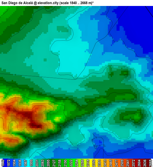
Below is the Elevation map of San Diego de Alcalá, which displays elevation range with different colors. Scale of the first map is from 1840 to 2668 m (6037 to 8753 ft) with average elevation of 2048.2 meters (=6720 ft) [note 1]
These maps also provides idea of topography and contour of this city, they are displayed at different zoom levels. More info about maps, scale and edge coordinates you can find below images.
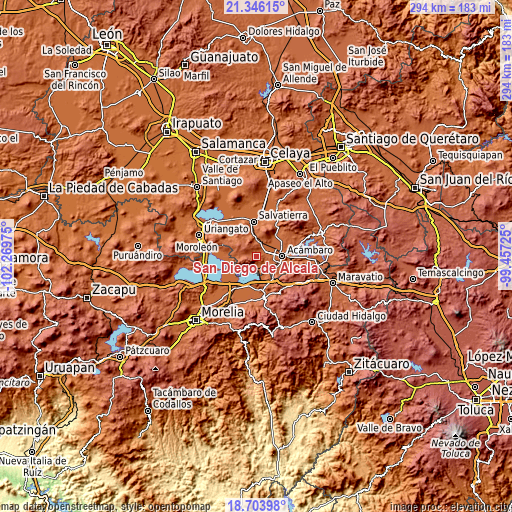
| \ | Map #1 | Topo.Map |
| Scale [m] | 1840..2668 m | × |
| Scale [ft] | 6037..8753 ft | × |
| Average | 2048.2 m = 6720 ft | × |
| Width | 9.18 km = 5.7 mi | 293.8 km = 182.6 mi |
| Height | 9.18 km = 5.7 mi | 293.8 km = 182.6 mi |
| ↑Max Latitude | 20.071902° | 21.34615° |
| Latitude at center | 20.03062° | 20.03062° |
| ↓Min Latitude | 19.989328° | 18.70398° |
| ← Min Longitude | -100.907445° | -102.26975° |
| Longitude center | -100.8635° | -100.8635° |
| →Max Longitude | -100.819555° | -99.45725° |
Nearby cities:
Cities around San Diego de Alcalá sort by population:
• Acámbaro elevation 1861 m
14.8 km,  89°
89°
• Irámuco 1844 m
9.8 km,  218°
218°
• Parácuaro 1863 m
16.4 km,  39°
39°
• San Miguel Eménguaro 1808 m
15 km,  351°
351°
• Araró 1852 m
13.9 km,  162°
162°
• Chamácuaro 1863 m
9 km,  24°
24°
• La Ortiga 1854 m
16.2 km,  242°
242°
• San Pablo Pejo 2076 m
7.8 km,  272°
272°
• San Juan Jaripeo 1885 m
11.1 km,  104°
104°
• San Antonio Eménguaro 1809 m
12.3 km, 352°
• Obrajuelo 1827 m
8.7 km,  9°
9°
• Los Desmontes 2054 m
15.4 km,  122°
122°
Multilingual:
 En español:
San Diego de Alcalá, San Diego elevación 2015 m.
 En France:
San Diego de Alcalá élévation 2015 m.
 Auf Deutsch:
San Diego de Alcalá höhe über dem Meeresspiegel ist 2015 m.
 На русском:
San Diego de Alcalá высота над уровнем моря 2015 м
Sources and notes:
- [note 1] Map square and city borders are not equal. Map elevation data is calculated only from area inside that square.
- [src 1] Elevation data from geonames database provided with same terms of usage.
- [src 2] The elevation map of San Diego de Alcalá is generated using elevation data from NASA's 3 arcsec (90m) resolution SRTM data.
- [src 3] Base (background) map © OpenStreetMap contributors tiles are generated by Geofabrik and OpenTopoMap.
Copyright & License:
This San Diego de Alcalá Elevation Map is licensed under CC BY-SA. You may reuse any part from this page, if you give a proper credit by linking to this URL:
 More info on terms of use page.