Irámuco elevation
Irámuco (Guanajuato, Acámbaro), Mexico elevation is 1844 meters and Irámuco elevation in feet is 6050 ft above sea level [src 1]. Irámuco is a populated place (feature code) with elevation that is 530 meters (1739 ft) bigger than average city elevation in Mexico.
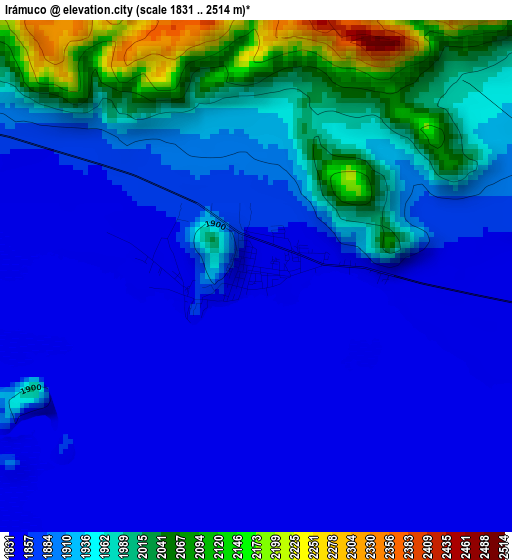
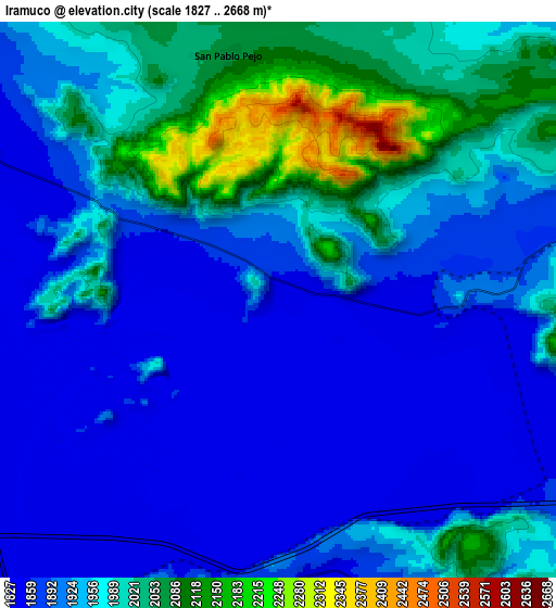
Below is the Elevation map of Irámuco, which displays elevation range with different colors. Scale of the first map is from 1831 to 2514 m (6007 to 8248 ft) with average elevation of 1909.7 meters (=6265 ft) [note 1]
These maps also provides idea of topography and contour of this city, they are displayed at different zoom levels. More info about maps, scale and edge coordinates you can find below images.
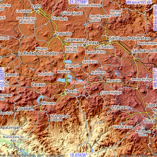
| \ | Map #1 | Map #2 | Topo.Map |
| Scale [m] | 1831..2514 m | 1827..2668 m | × |
| Scale [ft] | 6007..8248 ft | 5994..8753 ft | × |
| Average | 1909.7 m = 6265 ft | 1937.8 m = 6358 ft | × |
| Width | 9.19 km = 5.7 mi | 18.37 km = 11.4 mi | 293.9 km = 182.6 mi |
| Height | 9.19 km = 5.7 mi | 18.37 km = 11.4 mi | 293.9 km = 182.6 mi |
| ↑Max Latitude | 20.00286° | 20.044149° | 21.27769° |
| Latitude at center | 19.96156° | 19.96156° | 19.96156° |
| ↓Min Latitude | 19.920249° | 19.878928° | 18.63436° |
| ← Min Longitude | -100.965965° | -101.009911° | -102.32827° |
| Longitude center | -100.92202° | -100.92202° | -100.92202° |
| →Max Longitude | -100.878075° | -100.834129° | -99.51577° |
Nearby cities:
Cities around Irámuco sort by population:
• Estación Queréndaro elevation 1845 m
9.2 km,  197°
197°
• Santa Ana Maya 1844 m
11.6 km,  295°
295°
• Mariano Escobedo 1857 m
14.6 km,  271°
271°
• José María Morelos (La Yegüería) 1849 m
11.7 km,  157°
157°
• Tzintzimeo 1841 m
11.7 km,  209°
209°
• Araró 1852 m
11.6 km,  118°
118°
• La Ortiga 1854 m
8.2 km, 270°
• San Pablo Pejo 2076 m
8.2 km,  348°
348°
• San Diego de Alcalá 2015 m
9.8 km,  38°
38°
• Belisario Domínguez 1856 m
11.3 km, 207°
• Francisco Villa 1857 m
9.7 km,  188°
188°
• Felipe Carrillo Puerto 1857 m
14 km,  240°
240°
Multilingual:
 En español:
Irámuco elevación 1844 m.
 En France:
Irámuco élévation 1844 m.
 Auf Deutsch:
Irámuco höhe über dem Meeresspiegel ist 1844 m.

Sources and notes:
- [note 1] Map square and city borders are not equal. Map elevation data is calculated only from area inside that square.
- [src 1] Elevation data from geonames database provided with same terms of usage.
- [src 2] The elevation map of Irámuco is generated using elevation data from NASA's 3 arcsec (90m) resolution SRTM data.
- [src 3] Base (background) map © OpenStreetMap contributors tiles are generated by Geofabrik and OpenTopoMap.
Copyright & License:
This Irámuco Elevation Map is licensed under CC BY-SA. You may reuse any part from this page, if you give a proper credit by linking to this URL:
 More info on terms of use page.