Francisco Villa elevation
Francisco Villa (Michoacán, Zinapécuaro), Mexico elevation is 1857 meters and Francisco Villa elevation in feet is 6093 ft above sea level [src 1]. Francisco Villa is a populated place (feature code) with elevation that is 543 meters (1781 ft) bigger than average city elevation in Mexico.
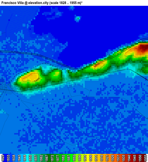
Below is the Elevation map of Francisco Villa, which displays elevation range with different colors. Scale of the first map is from 1828 to 1955 m (5997 to 6414 ft) with average elevation of 1841.3 meters (=6041 ft) [note 1]
These maps also provides idea of topography and contour of this city, they are displayed at different zoom levels. More info about maps, scale and edge coordinates you can find below images.
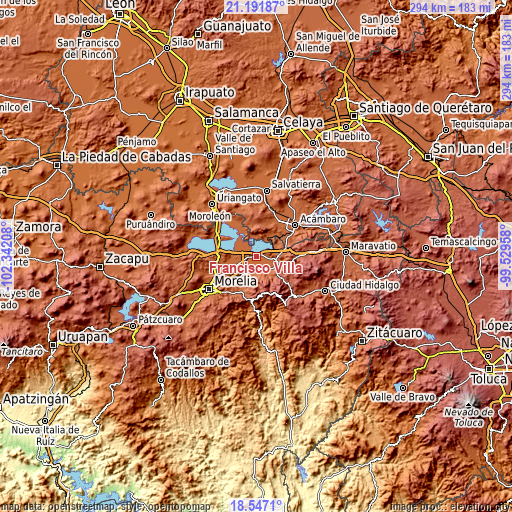
| \ | Map #1 | Topo.Map |
| Scale [m] | 1828..1955 m | × |
| Scale [ft] | 5997..6414 ft | × |
| Average | 1841.3 m = 6041 ft | × |
| Width | 9.19 km = 5.7 mi | 294.1 km = 182.7 mi |
| Height | 9.19 km = 5.7 mi | 294.1 km = 182.7 mi |
| ↑Max Latitude | 19.916322° | 21.19187° |
| Latitude at center | 19.875° | 19.875° |
| ↓Min Latitude | 19.833667° | 18.5471° |
| ← Min Longitude | -100.979775° | -102.34208° |
| Longitude center | -100.93583° | -100.93583° |
| →Max Longitude | -100.891885° | -99.52958° |
Nearby cities:
Cities around Francisco Villa sort by population:
• Zinapécuaro elevation 1886 m
11.3 km,  98°
98°
• Queréndaro 1848 m
8.7 km,  146°
146°
• Estación Queréndaro 1845 m
1.6 km,  303°
303°
• Indaparapeo 1930 m
10.3 km,  199°
199°
• Irámuco 1844 m
9.7 km,  8°
8°
• San Lucas Pío 1864 m
9.1 km,  172°
172°
• José María Morelos (La Yegüería) 1849 m
6.1 km, 101°
• Tzintzimeo 1841 m
4.4 km,  263°
263°
• Lázaro Cárdenas (La Purísima) 1846 m
9.1 km,  266°
266°
• Colonia de Guadalupe 1846 m
8.5 km, 165°
• Belisario Domínguez 1856 m
3.8 km, 263°
• Felipe Carrillo Puerto 1857 m
11 km,  283°
283°
Multilingual:
 En español:
Francisco Villa elevación 1857 m.
 En France:
Francisco Villa élévation 1857 m.
 Auf Deutsch:
Francisco Villa höhe über dem Meeresspiegel ist 1857 m.

Sources and notes:
- [note 1] Map square and city borders are not equal. Map elevation data is calculated only from area inside that square.
- [src 1] Elevation data from geonames database provided with same terms of usage.
- [src 2] The elevation map of Francisco Villa is generated using elevation data from NASA's 3 arcsec (90m) resolution SRTM data.
- [src 3] Base (background) map © OpenStreetMap contributors tiles are generated by Geofabrik and OpenTopoMap.
Copyright & License:
This Francisco Villa Elevation Map is licensed under CC BY-SA. You may reuse any part from this page, if you give a proper credit by linking to this URL:
 More info on terms of use page.