Zinapécuaro elevation
Zinapécuaro (Michoacán), Mexico elevation is 1886 meters and Zinapécuaro elevation in feet is 6188 ft above sea level [src 1]. Zinapécuaro is a seat of a second-order administrative division (feature code) with elevation that is 572 meters (1877 ft) bigger than average city elevation in Mexico.
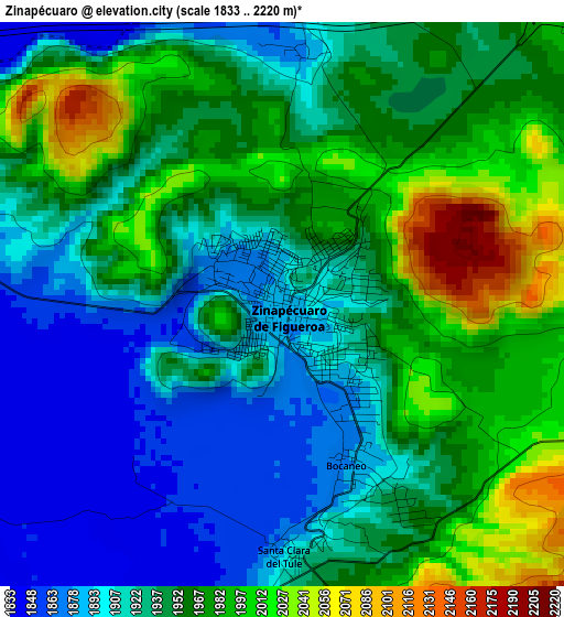
Below is the Elevation map of Zinapécuaro, which displays elevation range with different colors. Scale of the first map is from 1833 to 2220 m (6014 to 7283 ft) with average elevation of 1945.2 meters (=6382 ft) [note 1]
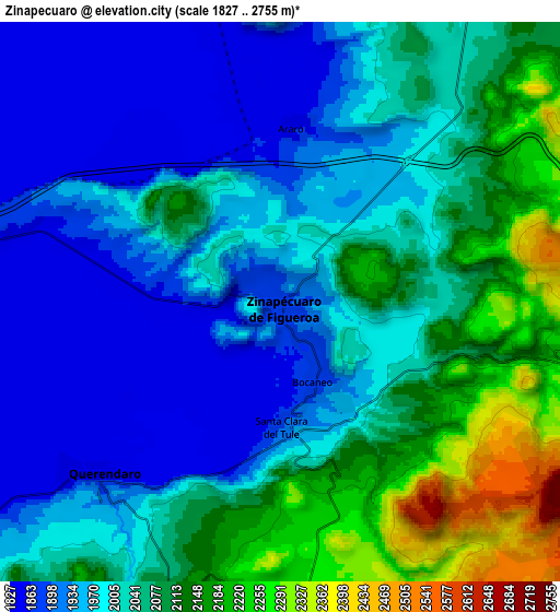
These maps also provides idea of topography and contour of this city, they are displayed at different zoom levels. More info about maps, scale and edge coordinates you can find below images.
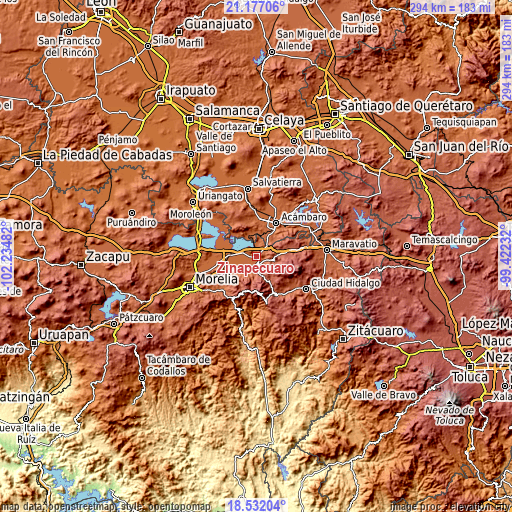
| \ | Map #1 | Map #2 | Topo.Map |
| Scale [m] | 1833..2220 m | 1827..2755 m | × |
| Scale [ft] | 6014..7283 ft | 5994..9039 ft | × |
| Average | 1945.2 m = 6382 ft | 2022.6 m = 6636 ft | × |
| Width | 9.19 km = 5.7 mi | 18.38 km = 11.4 mi | 294.1 km = 182.7 mi |
| Height | 9.19 km = 5.7 mi | 18.38 km = 11.4 mi | 294.1 km = 182.7 mi |
| ↑Max Latitude | 19.901386° | 19.942702° | 21.17706° |
| Latitude at center | 19.86006° | 19.86006° | 19.86006° |
| ↓Min Latitude | 19.818723° | 19.777375° | 18.53204° |
| ← Min Longitude | -100.872515° | -100.916461° | -102.23482° |
| Longitude center | -100.82857° | -100.82857° | -100.82857° |
| →Max Longitude | -100.784625° | -100.740679° | -99.42232° |
Nearby cities:
Cities around Zinapécuaro sort by population:
• Queréndaro elevation 1848 m
8.6 km,  229°
229°
• Estación Queréndaro 1845 m
12.8 km,  281°
281°
• San Lucas Pío 1864 m
12.5 km, 233°
• Bocaneo (San Pedro) 1879 m
2.7 km,  153°
153°
• José María Morelos (La Yegüería) 1849 m
5.3 km,  274°
274°
• Araró 1852 m
5.7 km,  4°
4°
• Santa Clara del Tule 1911 m
4 km,  177°
177°
• Ojo de Agua de Bucio 2558 m
13.7 km,  130°
130°
• Colonia de Guadalupe 1846 m
11.2 km, 234°
• Francisco Villa 1857 m
11.3 km, 278°
• Pueblo Viejo 2279 m
9.4 km,  171°
171°
• Los Desmontes 2054 m
14.2 km,  41°
41°
Multilingual:
 En español:
Zinapécuaro elevación 1886 m.
 En France:
Zinapécuaro élévation 1886 m.
 Auf Deutsch:
Zinapécuaro höhe über dem Meeresspiegel ist 1886 m.

Sources and notes:
- [note 1] Map square and city borders are not equal. Map elevation data is calculated only from area inside that square.
- [src 1] Elevation data from geonames database provided with same terms of usage.
- [src 2] The elevation map of Zinapécuaro is generated using elevation data from NASA's 3 arcsec (90m) resolution SRTM data.
- [src 3] Base (background) map © OpenStreetMap contributors tiles are generated by Geofabrik and OpenTopoMap.
Copyright & License:
This Zinapécuaro Elevation Map is licensed under CC BY-SA. You may reuse any part from this page, if you give a proper credit by linking to this URL:
 More info on terms of use page.