Don Diego elevation
Don Diego (Guanajuato, Comonfort), Mexico elevation is 1918 meters and Don Diego elevation in feet is 6293 ft above sea level [src 1]. Don Diego is a populated place (feature code) with elevation that is 604 meters (1982 ft) bigger than average city elevation in Mexico.
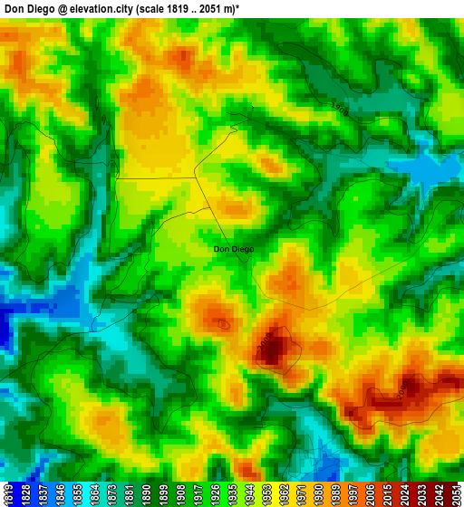
Below is the Elevation map of Don Diego, which displays elevation range with different colors. Scale of the first map is from 1819 to 2051 m (5968 to 6729 ft) with average elevation of 1926.8 meters (=6322 ft) [note 1]
These maps also provides idea of topography and contour of this city, they are displayed at different zoom levels. More info about maps, scale and edge coordinates you can find below images.
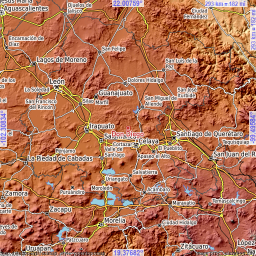
| \ | Map #1 | Topo.Map |
| Scale [m] | 1819..2051 m | × |
| Scale [ft] | 5968..6729 ft | × |
| Average | 1926.8 m = 6322 ft | × |
| Width | 9.14 km = 5.7 mi | 292.5 km = 181.8 mi |
| Height | 9.14 km = 5.7 mi | 292.5 km = 181.8 mi |
| ↑Max Latitude | 20.739013° | 22.00759° |
| Latitude at center | 20.69791° | 20.69791° |
| ↓Min Latitude | 20.656795° | 19.37682° |
| ← Min Longitude | -100.946035° | -102.30834° |
| Longitude center | -100.90209° | -100.90209° |
| →Max Longitude | -100.858145° | -99.49584° |
Nearby cities:
Cities around Don Diego sort by population:
• Neutla elevation 1826 m
6.6 km,  80°
80°
• Pozos 1767 m
8.7 km,  175°
175°
• Rincón del Centeno 1845 m
4.5 km,  157°
157°
• San Elías 1780 m
9.4 km,  137°
137°
• Delgado de Arriba 1918 m
2.7 km,  2°
2°
• Landín 1949 m
6.2 km,  356°
356°
• Santa Teresa 1789 m
8.1 km,  145°
145°
• El Naranjillo 1855 m
10.4 km,  280°
280°
• Palmillas de San Juan 1987 m
8.8 km,  26°
26°
• Los Dulces Nombres 1768 m
8.6 km,  229°
229°
• San Antonio de Corrales 2001 m
8.3 km,  309°
309°
• Delgado de Abajo 1902 m
2.4 km,  22°
22°
Multilingual:
 En español:
Don Diego elevación 1918 m.
 En France:
Don Diego élévation 1918 m.
 Auf Deutsch:
Don Diego höhe über dem Meeresspiegel ist 1918 m.

Sources and notes:
- [note 1] Map square and city borders are not equal. Map elevation data is calculated only from area inside that square.
- [src 1] Elevation data from geonames database provided with same terms of usage.
- [src 2] The elevation map of Don Diego is generated using elevation data from NASA's 3 arcsec (90m) resolution SRTM data.
- [src 3] Base (background) map © OpenStreetMap contributors tiles are generated by Geofabrik and OpenTopoMap.
Copyright & License:
This Don Diego Elevation Map is licensed under CC BY-SA. You may reuse any part from this page, if you give a proper credit by linking to this URL:
 More info on terms of use page.