San Elías elevation
San Elías (Guanajuato, Celaya), Mexico elevation is 1780 meters and San Elías elevation in feet is 5840 ft above sea level [src 1]. San Elías is a populated place (feature code) with elevation that is 466 meters (1529 ft) bigger than average city elevation in Mexico.
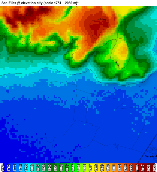
Below is the Elevation map of San Elías, which displays elevation range with different colors. Scale of the first map is from 1751 to 2039 m (5745 to 6690 ft) with average elevation of 1824.9 meters (=5987 ft) [note 1]
These maps also provides idea of topography and contour of this city, they are displayed at different zoom levels. More info about maps, scale and edge coordinates you can find below images.
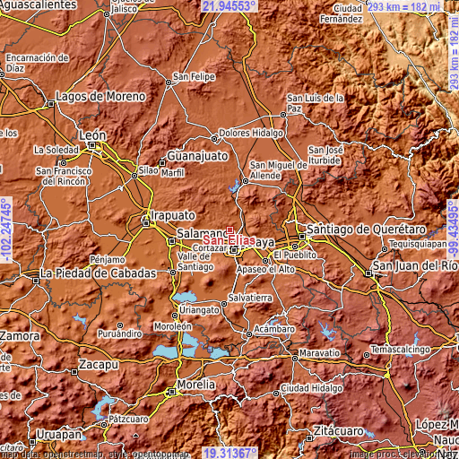
| \ | Map #1 | Topo.Map |
| Scale [m] | 1751..2039 m | × |
| Scale [ft] | 5745..6690 ft | × |
| Average | 1824.9 m = 5987 ft | × |
| Width | 9.15 km = 5.7 mi | 292.6 km = 181.8 mi |
| Height | 9.15 km = 5.7 mi | 292.7 km = 181.9 mi |
| ↑Max Latitude | 20.67641° | 21.94553° |
| Latitude at center | 20.63529° | 20.63529° |
| ↓Min Latitude | 20.594159° | 19.31367° |
| ← Min Longitude | -100.885145° | -102.24745° |
| Longitude center | -100.8412° | -100.8412° |
| →Max Longitude | -100.797255° | -99.43495° |
Nearby cities:
Cities around San Elías sort by population:
• Tenería del Santuario elevation 1770 m
6 km,  131°
131°
• Roque 1764 m
5.9 km,  176°
176°
• San Antonio Gallardo 1776 m
7.7 km,  95°
95°
• Pozos 1767 m
5.9 km,  253°
253°
• Rincón del Centeno 1845 m
5.4 km,  301°
301°
• San Isidro de la Concepción 1775 m
5.8 km, 98°
• Plancarte 1768 m
7.1 km,  139°
139°
• Presa Blanca 1780 m
5.1 km,  82°
82°
• Gasca 1765 m
3.8 km,  204°
204°
• Santa Teresa 1789 m
1.7 km,  281°
281°
• Yustis 1758 m
6.3 km, 201°
• San Cayetano 1770 m
4.1 km,  148°
148°
Multilingual:
 En español:
San Elías elevación 1780 m.
 En France:
San Elías élévation 1780 m.
 Auf Deutsch:
San Elías höhe über dem Meeresspiegel ist 1780 m.

Sources and notes:
- [note 1] Map square and city borders are not equal. Map elevation data is calculated only from area inside that square.
- [src 1] Elevation data from geonames database provided with same terms of usage.
- [src 2] The elevation map of San Elías is generated using elevation data from NASA's 3 arcsec (90m) resolution SRTM data.
- [src 3] Base (background) map © OpenStreetMap contributors tiles are generated by Geofabrik and OpenTopoMap.
Copyright & License:
This San Elías Elevation Map is licensed under CC BY-SA. You may reuse any part from this page, if you give a proper credit by linking to this URL:
 More info on terms of use page.