Gasca elevation
Gasca (Guanajuato, Celaya), Mexico elevation is 1765 meters and Gasca elevation in feet is 5791 ft above sea level [src 1]. Gasca is a populated place (feature code) with elevation that is 451 meters (1480 ft) bigger than average city elevation in Mexico.
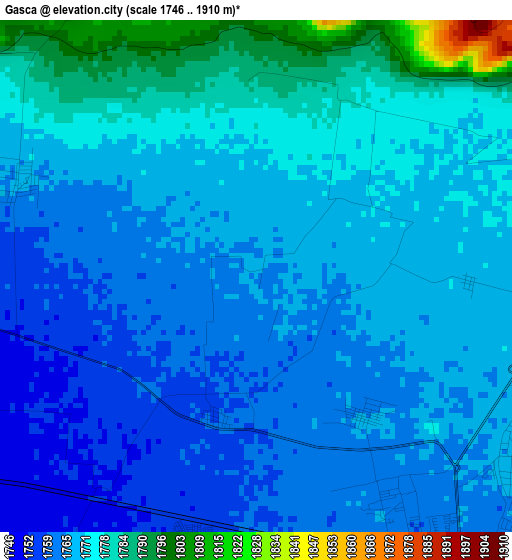
Below is the Elevation map of Gasca, which displays elevation range with different colors. Scale of the first map is from 1746 to 1910 m (5728 to 6266 ft) with average elevation of 1769.2 meters (=5804 ft) [note 1]
These maps also provides idea of topography and contour of this city, they are displayed at different zoom levels. More info about maps, scale and edge coordinates you can find below images.
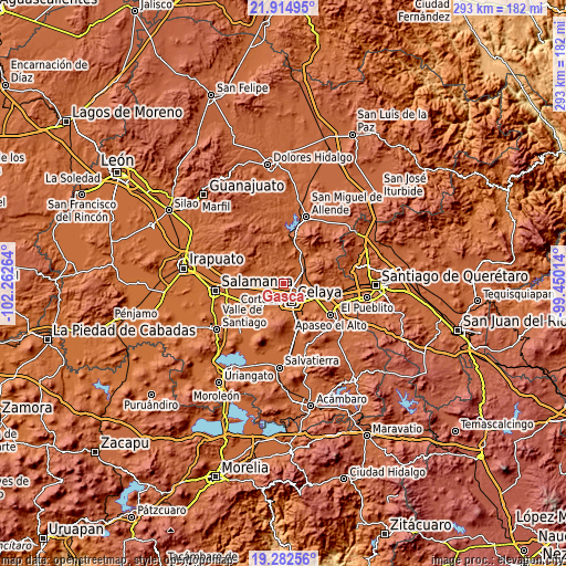
| \ | Map #1 | Topo.Map |
| Scale [m] | 1746..1910 m | × |
| Scale [ft] | 5728..6266 ft | × |
| Average | 1769.2 m = 5804 ft | × |
| Width | 9.15 km = 5.7 mi | 292.7 km = 181.9 mi |
| Height | 9.15 km = 5.7 mi | 292.7 km = 181.9 mi |
| ↑Max Latitude | 20.645569° | 21.91495° |
| Latitude at center | 20.60444° | 20.60444° |
| ↓Min Latitude | 20.5633° | 19.28256° |
| ← Min Longitude | -100.900335° | -102.26264° |
| Longitude center | -100.85639° | -100.85639° |
| →Max Longitude | -100.812445° | -99.45014° |
Nearby cities:
Cities around Gasca sort by population:
• Tenería del Santuario elevation 1770 m
6.1 km,  95°
95°
• Roque 1764 m
3.2 km,  141°
141°
• Pozos 1767 m
4.4 km,  293°
293°
• Rincón del Centeno 1845 m
6.9 km,  334°
334°
• San José de Guanajuato 1749 m
6.6 km,  215°
215°
• San Elías 1780 m
3.8 km,  24°
24°
• Plancarte 1768 m
6.6 km,  107°
107°
• San Antonio de los Morales 1750 m
6.2 km,  244°
244°
• Santa Teresa 1789 m
3.8 km,  358°
358°
• Yustis 1758 m
2.6 km,  197°
197°
• Franco Tavera 1749 m
7.4 km,  271°
271°
• San Cayetano 1770 m
3.8 km,  91°
91°
Multilingual:
 En español:
Gasca elevación 1765 m.
 En France:
Gasca élévation 1765 m.


Sources and notes:
- [note 1] Map square and city borders are not equal. Map elevation data is calculated only from area inside that square.
- [src 1] Elevation data from geonames database provided with same terms of usage.
- [src 2] The elevation map of Gasca is generated using elevation data from NASA's 3 arcsec (90m) resolution SRTM data.
- [src 3] Base (background) map © OpenStreetMap contributors tiles are generated by Geofabrik and OpenTopoMap.
Copyright & License:
This Gasca Elevation Map is licensed under CC BY-SA. You may reuse any part from this page, if you give a proper credit by linking to this URL:
 More info on terms of use page.