Tenería del Santuario elevation
Tenería del Santuario (Guanajuato, Celaya), Mexico elevation is 1770 meters and Tenería del Santuario elevation in feet is 5807 ft above sea level [src 1]. Tenería del Santuario is a populated place (feature code) with elevation that is 456 meters (1496 ft) bigger than average city elevation in Mexico.
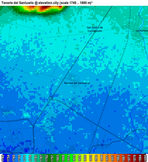
Below is the Elevation map of Tenería del Santuario, which displays elevation range with different colors. Scale of the first map is from 1749 to 1889 m (5738 to 6198 ft) with average elevation of 1769.4 meters (=5805 ft) [note 1]
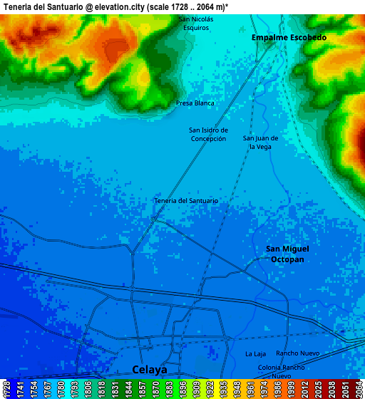
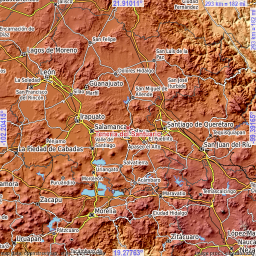
These maps also provides idea of topography and contour of this city, they are displayed at different zoom levels. More info about maps, scale and edge coordinates you can find below images.
| \ | Map #1 | Map #2 | Topo.Map |
| Scale [m] | 1749..1889 m | 1728..2064 m | × |
| Scale [ft] | 5738..6198 ft | 5669..6772 ft | × |
| Average | 1769.4 m = 5805 ft | 1792.3 m = 5880 ft | × |
| Width | 9.15 km = 5.7 mi | 18.3 km = 11.4 mi | 292.7 km = 181.9 mi |
| Height | 9.15 km = 5.7 mi | 18.3 km = 11.4 mi | 292.7 km = 181.9 mi |
| ↑Max Latitude | 20.64068° | 20.681799° | 21.91011° |
| Latitude at center | 20.59955° | 20.59955° | 20.59955° |
| ↓Min Latitude | 20.558409° | 20.517257° | 19.27763° |
| ← Min Longitude | -100.841845° | -100.885791° | -102.20415° |
| Longitude center | -100.7979° | -100.7979° | -100.7979° |
| →Max Longitude | -100.753955° | -100.710009° | -99.39165° |
Nearby cities:
Cities around Tenería del Santuario sort by population:
• San Miguel Octopan elevation 1767 m
5.9 km,  118°
118°
• San Juan de la Vega 1777 m
4.7 km,  53°
53°
• Roque 1764 m
4.5 km,  244°
244°
• San Antonio Gallardo 1776 m
4.5 km,  44°
44°
• La Aurora 1778 m
5.2 km, 54°
• San Elías 1780 m
6 km,  311°
311°
• San Isidro de la Concepción 1775 m
3.4 km,  22°
22°
• Plancarte 1768 m
1.4 km,  172°
172°
• Presa Blanca 1780 m
4.7 km,  6°
6°
• Gasca 1765 m
6.1 km,  275°
275°
• La Trinidad 1764 m
4.3 km,  159°
159°
• San Cayetano 1770 m
2.4 km, 280°
Multilingual:
 En español:
Tenería del Santuario, Tenería elevación 1770 m.
 En France:
Tenería del Santuario élévation 1770 m.
 Auf Deutsch:
Tenería del Santuario höhe über dem Meeresspiegel ist 1770 m.
 На русском:
Tenería del Santuario высота над уровнем моря 1770 м
Sources and notes:
- [note 1] Map square and city borders are not equal. Map elevation data is calculated only from area inside that square.
- [src 1] Elevation data from geonames database provided with same terms of usage.
- [src 2] The elevation map of Tenería del Santuario is generated using elevation data from NASA's 3 arcsec (90m) resolution SRTM data.
- [src 3] Base (background) map © OpenStreetMap contributors tiles are generated by Geofabrik and OpenTopoMap.
Copyright & License:
This Tenería del Santuario Elevation Map is licensed under CC BY-SA. You may reuse any part from this page, if you give a proper credit by linking to this URL:
 More info on terms of use page.