El Naranjillo elevation
El Naranjillo (Guanajuato, Santa Cruz de Juventino Rosas), Mexico elevation is 1855 meters and El Naranjillo elevation in feet is 6086 ft above sea level [src 1]. El Naranjillo is a populated place (feature code) with elevation that is 541 meters (1775 ft) bigger than average city elevation in Mexico.
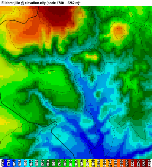
Below is the Elevation map of El Naranjillo, which displays elevation range with different colors. Scale of the first map is from 1780 to 2282 m (5840 to 7487 ft) with average elevation of 1961 meters (=6434 ft) [note 1]
These maps also provides idea of topography and contour of this city, they are displayed at different zoom levels. More info about maps, scale and edge coordinates you can find below images.
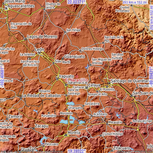
| \ | Map #1 | Topo.Map |
| Scale [m] | 1780..2282 m | × |
| Scale [ft] | 5840..7487 ft | × |
| Average | 1961 m = 6434 ft | × |
| Width | 9.14 km = 5.7 mi | 292.5 km = 181.8 mi |
| Height | 9.14 km = 5.7 mi | 292.5 km = 181.8 mi |
| ↑Max Latitude | 20.755269° | 22.02371° |
| Latitude at center | 20.71417° | 20.71417° |
| ↓Min Latitude | 20.67306° | 19.39322° |
| ← Min Longitude | -101.044505° | -102.40681° |
| Longitude center | -101.00056° | -101.00056° |
| →Max Longitude | -100.956615° | -99.59431° |
Nearby cities:
Cities around El Naranjillo sort by population:
• Juventino Rosas elevation 1756 m
7.9 km,  174°
174°
• Santiago de Cuenda 1741 m
12.8 km,  176°
176°
• Delgado de Arriba 1918 m
10.4 km,  85°
85°
• Barrón 1853 m
9.7 km,  244°
244°
• Landín 1949 m
10.8 km,  65°
65°
• Los Dulces Nombres 1768 m
8.2 km,  153°
153°
• La Ordeña 1810 m
12.5 km,  257°
257°
• Cerrito de Gasca 1746 m
12.4 km,  210°
210°
• San Antonio de Corrales 2001 m
5.2 km,  47°
47°
• Delgado de Abajo 1902 m
11.2 km, 88°
• Don Diego 1918 m
10.4 km,  100°
100°
• San José de las Pilas 1815 m
8.3 km, 214°
Multilingual:
 En español:
El Naranjillo elevación 1855 m.
 En France:
El Naranjillo élévation 1855 m.
 Auf Deutsch:
El Naranjillo höhe über dem Meeresspiegel ist 1855 m.

Sources and notes:
- [note 1] Map square and city borders are not equal. Map elevation data is calculated only from area inside that square.
- [src 1] Elevation data from geonames database provided with same terms of usage.
- [src 2] The elevation map of El Naranjillo is generated using elevation data from NASA's 3 arcsec (90m) resolution SRTM data.
- [src 3] Base (background) map © OpenStreetMap contributors tiles are generated by Geofabrik and OpenTopoMap.
Copyright & License:
This El Naranjillo Elevation Map is licensed under CC BY-SA. You may reuse any part from this page, if you give a proper credit by linking to this URL:
 More info on terms of use page.