Amatitán elevation
Amatitán (Jalisco), Mexico elevation is 1251 meters and Amatitán elevation in feet is 4104 ft above sea level [src 1]. Amatitán is a seat of a second-order administrative division (feature code) with elevation that is 63 meters (207 ft) smaller than average city elevation in Mexico.
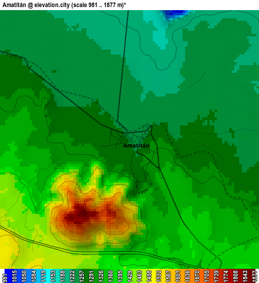
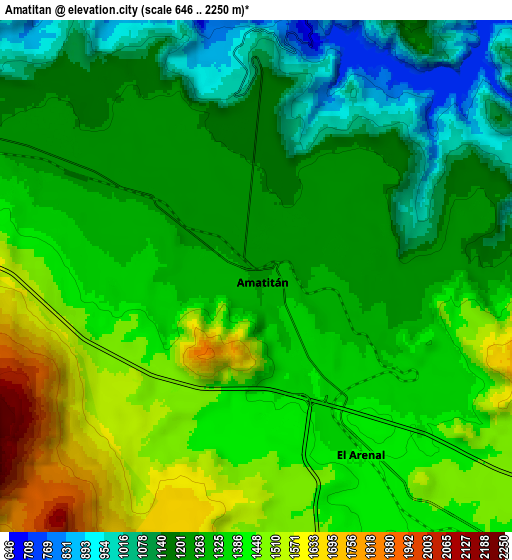
Below is the Elevation map of Amatitán, which displays elevation range with different colors. Scale of the first map is from 981 to 1877 m (3219 to 6158 ft) with average elevation of 1317.7 meters (=4323 ft) [note 1]
These maps also provides idea of topography and contour of this city, they are displayed at different zoom levels. More info about maps, scale and edge coordinates you can find below images.
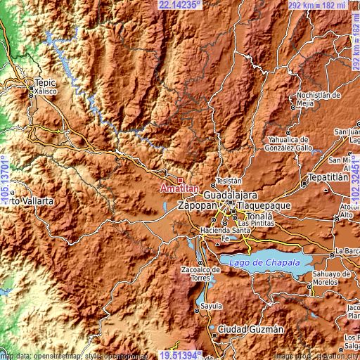
| \ | Map #1 | Map #2 | Topo.Map |
| Scale [m] | 981..1877 m | 646..2250 m | × |
| Scale [ft] | 3219..6158 ft | 2119..7382 ft | × |
| Average | 1317.7 m = 4323 ft | 1312.1 m = 4305 ft | × |
| Width | 9.13 km = 5.7 mi | 18.27 km = 11.4 mi | 292.3 km = 181.6 mi |
| Height | 9.13 km = 5.7 mi | 18.27 km = 11.4 mi | 292.3 km = 181.6 mi |
| ↑Max Latitude | 20.874946° | 20.916002° | 22.14235° |
| Latitude at center | 20.83388° | 20.83388° | 20.83388° |
| ↓Min Latitude | 20.792802° | 20.751714° | 19.51394° |
| ← Min Longitude | -103.774705° | -103.818651° | -105.13701° |
| Longitude center | -103.73076° | -103.73076° | -103.73076° |
| →Max Longitude | -103.686815° | -103.642869° | -102.32451° |
Nearby cities:
Cities around Amatitán sort by population:
• Tala elevation 1338 m
20.3 km,  171°
171°
• Tequila 1197 m
12.2 km,  296°
296°
• El Arenal 1389 m
7.6 km,  149°
149°
• Los Ruiseñores 1396 m
14.3 km,  163°
163°
• El Refugio 1302 m
18.1 km,  182°
182°
• Teuchitlán 1269 m
20.7 km,  216°
216°
• Santa Cruz del Astillero 1437 m
13.3 km,  136°
136°
• El Salvador 1834 m
20.4 km,  4°
4°
• La Estanzuela 1264 m
20.8 km,  208°
208°
• Huaxtla 1420 m
13.4 km, 148°
• Santa Teresa 1193 m
19.1 km, 298°
• Santiaguito 1422 m
6 km, 173°
Multilingual:
 En español:
Amatitán elevación 1251 m.
 En France:
Amatitán élévation 1251 m.
 Auf Deutsch:
Amatitán höhe über dem Meeresspiegel ist 1251 m.

Sources and notes:
- [note 1] Map square and city borders are not equal. Map elevation data is calculated only from area inside that square.
- [src 1] Elevation data from geonames database provided with same terms of usage.
- [src 2] The elevation map of Amatitán is generated using elevation data from NASA's 3 arcsec (90m) resolution SRTM data.
- [src 3] Base (background) map © OpenStreetMap contributors tiles are generated by Geofabrik and OpenTopoMap.
Copyright & License:
This Amatitán Elevation Map is licensed under CC BY-SA. You may reuse any part from this page, if you give a proper credit by linking to this URL:
 More info on terms of use page.