Tequila elevation
Tequila (Jalisco), Mexico elevation is 1197 meters and Tequila elevation in feet is 3927 ft above sea level [src 1]. Tequila is a seat of a second-order administrative division (feature code) with elevation that is 117 meters (384 ft) smaller than average city elevation in Mexico.
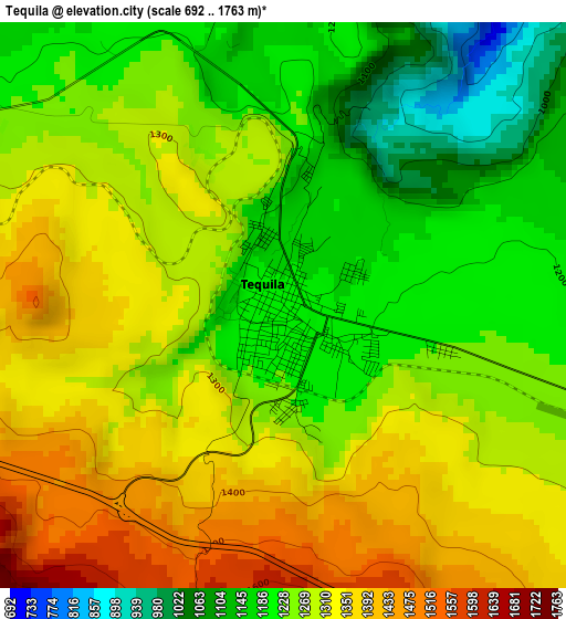
Below is the Elevation map of Tequila, which displays elevation range with different colors. Scale of the first map is from 692 to 1763 m (2270 to 5784 ft) with average elevation of 1271.9 meters (=4173 ft) [note 1]
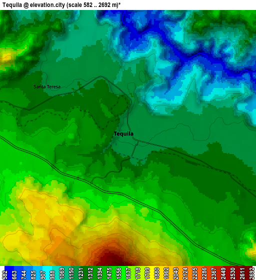
These maps also provides idea of topography and contour of this city, they are displayed at different zoom levels. More info about maps, scale and edge coordinates you can find below images.
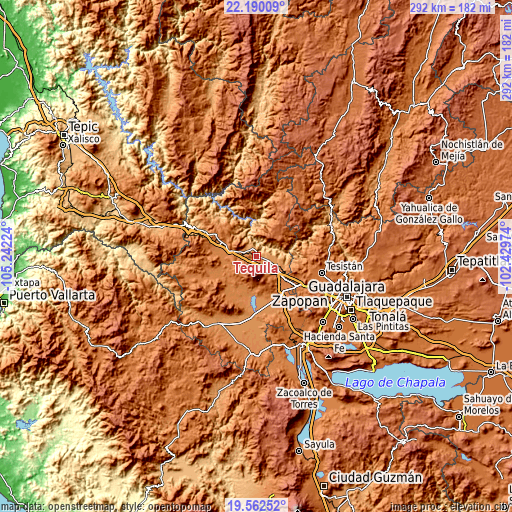
| \ | Map #1 | Map #2 | Topo.Map |
| Scale [m] | 692..1763 m | 582..2692 m | × |
| Scale [ft] | 2270..5784 ft | 1909..8832 ft | × |
| Average | 1271.9 m = 4173 ft | 1346.3 m = 4417 ft | × |
| Width | 9.13 km = 5.7 mi | 18.26 km = 11.3 mi | 292.2 km = 181.6 mi |
| Height | 9.13 km = 5.7 mi | 18.26 km = 11.3 mi | 292.2 km = 181.6 mi |
| ↑Max Latitude | 20.923103° | 20.964145° | 22.19009° |
| Latitude at center | 20.88205° | 20.88205° | 20.88205° |
| ↓Min Latitude | 20.840986° | 20.79991° | 19.56252° |
| ← Min Longitude | -103.879935° | -103.923881° | -105.24224° |
| Longitude center | -103.83599° | -103.83599° | -103.83599° |
| →Max Longitude | -103.792045° | -103.748099° | -102.42974° |
Nearby cities:
Cities around Tequila sort by population:
• Magdalena elevation 1379 m
15 km,  280°
280°
• El Arenal 1389 m
19 km,  128°
128°
• Amatitán 1251 m
12.2 km,  116°
116°
• Los Ruiseñores 1396 m
24.3 km,  141°
141°
• San Juanito de Escobedo 1378 m
19.9 km,  240°
240°
• Antonio Escobedo 1360 m
20.9 km, 244°
• Teuchitlán 1269 m
22 km,  183°
183°
• El Salvador 1834 m
19.5 km,  39°
39°
• La Estanzuela 1264 m
23.7 km, 177°
• Santa Teresa 1193 m
6.9 km,  302°
302°
• Santiaguito 1422 m
16.3 km, 134°
• La Quemada 1399 m
24.3 km,  294°
294°
Multilingual:
 En español:
Tequila elevación 1197 m.
 En France:
Tequila élévation 1197 m.
 Auf Deutsch:
Municipio Tequila höhe über dem Meeresspiegel ist 1197 m.

Sources and notes:
- [note 1] Map square and city borders are not equal. Map elevation data is calculated only from area inside that square.
- [src 1] Elevation data from geonames database provided with same terms of usage.
- [src 2] The elevation map of Tequila is generated using elevation data from NASA's 3 arcsec (90m) resolution SRTM data.
- [src 3] Base (background) map © OpenStreetMap contributors tiles are generated by Geofabrik and OpenTopoMap.
Copyright & License:
This Tequila Elevation Map is licensed under CC BY-SA. You may reuse any part from this page, if you give a proper credit by linking to this URL:
 More info on terms of use page.