Magdalena elevation
Magdalena (Jalisco), Mexico elevation is 1379 meters and Magdalena elevation in feet is 4524 ft above sea level [src 1]. Magdalena is a seat of a second-order administrative division (feature code) with elevation that is 65 meters (213 ft) bigger than average city elevation in Mexico.
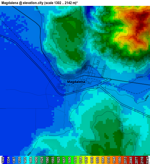
Below is the Elevation map of Magdalena, which displays elevation range with different colors. Scale of the first map is from 1302 to 2142 m (4272 to 7028 ft) with average elevation of 1465.3 meters (=4807 ft) [note 1]
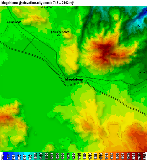
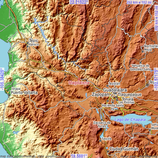
These maps also provides idea of topography and contour of this city, they are displayed at different zoom levels. More info about maps, scale and edge coordinates you can find below images.
| \ | Map #1 | Map #2 | Topo.Map |
| Scale [m] | 1302..2142 m | 718..2142 m | × |
| Scale [ft] | 4272..7028 ft | 2356..7028 ft | × |
| Average | 1465.3 m = 4807 ft | 1435.8 m = 4711 ft | × |
| Width | 9.13 km = 5.7 mi | 18.26 km = 11.3 mi | 292.1 km = 181.5 mi |
| Height | 9.13 km = 5.7 mi | 18.26 km = 11.3 mi | 292.1 km = 181.5 mi |
| ↑Max Latitude | 20.948456° | 20.989491° | 22.21522° |
| Latitude at center | 20.90741° | 20.90741° | 20.90741° |
| ↓Min Latitude | 20.866353° | 20.825284° | 19.5881° |
| ← Min Longitude | -104.021945° | -104.065891° | -105.38425° |
| Longitude center | -103.978° | -103.978° | -103.978° |
| →Max Longitude | -103.934055° | -103.890109° | -102.57175° |
Nearby cities:
Cities around Magdalena sort by population:
• Tequila elevation 1197 m
15 km,  100°
100°
• Ahualulco de Mercado 1325 m
22.9 km,  179°
179°
• Etzatlán 1401 m
18.6 km,  213°
213°
• San Juanito de Escobedo 1378 m
12.8 km,  191°
191°
• Antonio Escobedo 1360 m
12.6 km,  198°
198°
• Hostotipaquillo 1303 m
18.6 km,  336°
336°
• San Marcos 1382 m
26.1 km,  240°
240°
• San Andrés 1390 m
11.6 km,  279°
279°
• Santa Cruz de Bárcenas 1407 m
26.7 km, 185°
• Santa Teresa 1193 m
9 km,  83°
83°
• La Quemada 1399 m
10.2 km,  313°
313°
• Santa Rosalía 1379 m
15 km,  228°
228°
Multilingual:
 En español:
Magdalena elevación 1379 m.
 En France:
Magdalena élévation 1379 m.
 Auf Deutsch:
Magdalena höhe über dem Meeresspiegel ist 1379 m.

Sources and notes:
- [note 1] Map square and city borders are not equal. Map elevation data is calculated only from area inside that square.
- [src 1] Elevation data from geonames database provided with same terms of usage.
- [src 2] The elevation map of Magdalena is generated using elevation data from NASA's 3 arcsec (90m) resolution SRTM data.
- [src 3] Base (background) map © OpenStreetMap contributors tiles are generated by Geofabrik and OpenTopoMap.
Copyright & License:
This Magdalena Elevation Map is licensed under CC BY-SA. You may reuse any part from this page, if you give a proper credit by linking to this URL:
 More info on terms of use page.