Hostotipaquillo elevation
Hostotipaquillo (Jalisco), Mexico elevation is 1303 meters and Hostotipaquillo elevation in feet is 4275 ft above sea level [src 1]. Hostotipaquillo is a seat of a second-order administrative division (feature code) with elevation that is 11 meters (36 ft) smaller than average city elevation in Mexico.
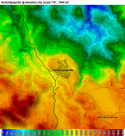
Below is the Elevation map of Hostotipaquillo, which displays elevation range with different colors. Scale of the first map is from 716 to 1644 m (2349 to 5394 ft) with average elevation of 1205.8 meters (=3956 ft) [note 1]
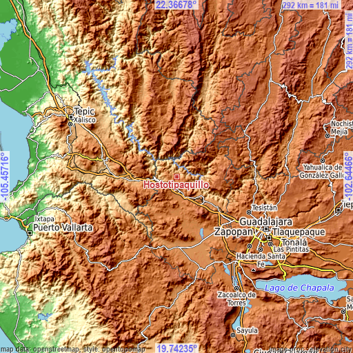
These maps also provides idea of topography and contour of this city, they are displayed at different zoom levels. More info about maps, scale and edge coordinates you can find below images.
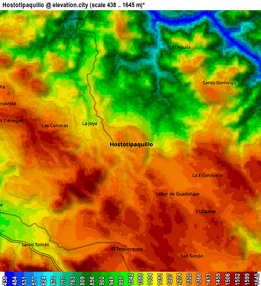
| \ | Map #1 | Map #2 | Topo.Map |
| Scale [m] | 716..1644 m | 438..1645 m | × |
| Scale [ft] | 2349..5394 ft | 1437..5397 ft | × |
| Average | 1205.8 m = 3956 ft | 1203.8 m = 3949 ft | × |
| Width | 9.12 km = 5.7 mi | 18.24 km = 11.3 mi | 291.8 km = 181.3 mi |
| Height | 9.12 km = 5.7 mi | 18.24 km = 11.3 mi | 291.8 km = 181.3 mi |
| ↑Max Latitude | 21.101354° | 21.142347° | 22.36678° |
| Latitude at center | 21.06035° | 21.06035° | 21.06035° |
| ↓Min Latitude | 21.019334° | 20.978308° | 19.74235° |
| ← Min Longitude | -104.094855° | -104.138801° | -105.45716° |
| Longitude center | -104.05091° | -104.05091° | -104.05091° |
| →Max Longitude | -104.006965° | -103.963019° | -102.64466° |
Nearby cities:
Cities around Hostotipaquillo sort by population:
• Tequila elevation 1197 m
29.8 km,  131°
131°
• Magdalena 1379 m
18.6 km,  156°
156°
• Etzatlán 1401 m
32.6 km,  184°
184°
• San Juanito de Escobedo 1378 m
30 km,  170°
170°
• Antonio Escobedo 1360 m
29.2 km, 172°
• Rosa Blanca 1939 m
32.7 km,  282°
282°
• San Andrés 1390 m
15.6 km,  194°
194°
• Santa Teresa 1193 m
23 km, 134°
• La Quemada 1399 m
9.9 km, 178°
• Santa Rosalía 1379 m
27.3 km, 187°
• Los Aguajes 1909 m
31.9 km, 279°
• La Yesca 1434 m
29 km,  8°
8°
Multilingual:
 En español:
Hostotipaquillo elevación 1303 m.
 En France:
Hostotipaquillo élévation 1303 m.
 Auf Deutsch:
Hostotipaquillo höhe über dem Meeresspiegel ist 1303 m.

Sources and notes:
- [note 1] Map square and city borders are not equal. Map elevation data is calculated only from area inside that square.
- [src 1] Elevation data from geonames database provided with same terms of usage.
- [src 2] The elevation map of Hostotipaquillo is generated using elevation data from NASA's 3 arcsec (90m) resolution SRTM data.
- [src 3] Base (background) map © OpenStreetMap contributors tiles are generated by Geofabrik and OpenTopoMap.
Copyright & License:
This Hostotipaquillo Elevation Map is licensed under CC BY-SA. You may reuse any part from this page, if you give a proper credit by linking to this URL:
 More info on terms of use page.