La Yesca elevation
La Yesca (Nayarit), Mexico elevation is 1434 meters and La Yesca elevation in feet is 4705 ft above sea level [src 1]. La Yesca is a seat of a second-order administrative division (feature code) with elevation that is 120 meters (394 ft) bigger than average city elevation in Mexico.
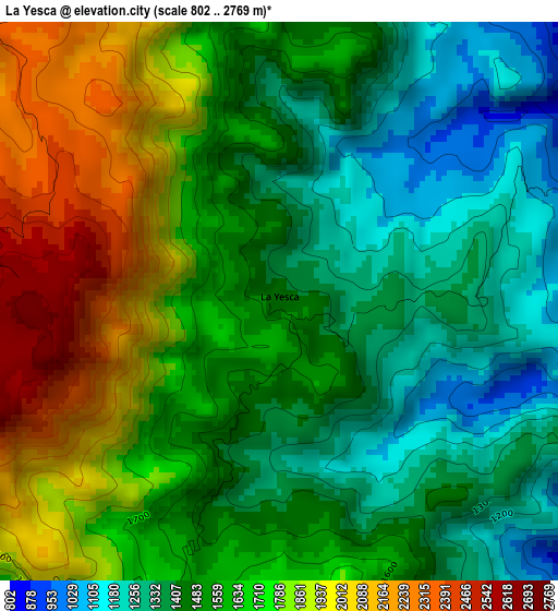
Below is the Elevation map of La Yesca, which displays elevation range with different colors. Scale of the first map is from 802 to 2769 m (2631 to 9085 ft) with average elevation of 1591.7 meters (=5222 ft) [note 1]
These maps also provides idea of topography and contour of this city, they are displayed at different zoom levels. More info about maps, scale and edge coordinates you can find below images.
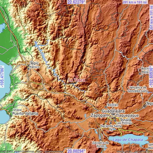
| \ | Map #1 | Topo.Map |
| Scale [m] | 802..2769 m | × |
| Scale [ft] | 2631..9085 ft | × |
| Average | 1591.7 m = 5222 ft | × |
| Width | 9.1 km = 5.7 mi | 291.3 km = 181 mi |
| Height | 9.1 km = 5.7 mi | 291.3 km = 181 mi |
| ↑Max Latitude | 21.359643° | 22.62279° |
| Latitude at center | 21.31871° | 21.31871° |
| ↓Min Latitude | 21.277766° | 20.00294° |
| ← Min Longitude | -104.055555° | -105.41786° |
| Longitude center | -104.01161° | -104.01161° |
| →Max Longitude | -103.967665° | -102.60536° |
Nearby cities:
Cities around La Yesca sort by population:
• Ixtlán del Río elevation 1049 m
48.5 km,  230°
230°
• Magdalena 1379 m
45.9 km,  175°
175°
• Jomulco 1068 m
48.9 km,  240°
240°
• Hostotipaquillo 1303 m
29 km,  188°
188°
• Rosa Blanca 1939 m
41.9 km, 238°
• El Salvador 1834 m
45.5 km,  137°
137°
• San Martín de Bolaños 813 m
45.4 km,  26°
26°
• Puente de Camotlán 1142 m
42.8 km,  350°
350°
• San Andrés 1390 m
44.5 km, 190°
• Santa Teresa 1193 m
46.5 km,  164°
164°
• La Quemada 1399 m
38.8 km, 185°
• Los Aguajes 1909 m
42.6 km, 236°
Multilingual:
 En español:
La Yesca elevación 1434 m.
 En France:
La Yesca élévation 1434 m.
 Auf Deutsch:
La Yesca höhe über dem Meeresspiegel ist 1434 m.

Sources and notes:
- [note 1] Map square and city borders are not equal. Map elevation data is calculated only from area inside that square.
- [src 1] Elevation data from geonames database provided with same terms of usage.
- [src 2] The elevation map of La Yesca is generated using elevation data from NASA's 3 arcsec (90m) resolution SRTM data.
- [src 3] Base (background) map © OpenStreetMap contributors tiles are generated by Geofabrik and OpenTopoMap.
Copyright & License:
This La Yesca Elevation Map is licensed under CC BY-SA. You may reuse any part from this page, if you give a proper credit by linking to this URL:
 More info on terms of use page.