Bustamante elevation
Bustamante (Nuevo León), Mexico elevation is 461 meters and Bustamante elevation in feet is 1512 ft above sea level [src 1]. Bustamante is a seat of a second-order administrative division (feature code) with elevation that is 853 meters (2799 ft) smaller than average city elevation in Mexico.
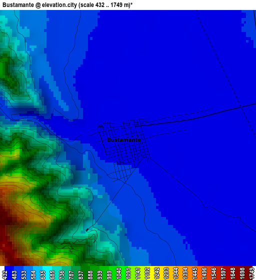
Below is the Elevation map of Bustamante, which displays elevation range with different colors. Scale of the first map is from 432 to 1749 m (1417 to 5738 ft) with average elevation of 578.9 meters (=1899 ft) [note 1]
These maps also provides idea of topography and contour of this city, they are displayed at different zoom levels. More info about maps, scale and edge coordinates you can find below images.

| \ | Map #1 | Map #2 | Topo.Map |
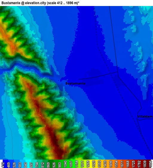
| Scale [m] | 432..1749 m | 412..1896 m | × |
| Scale [ft] | 1417..5738 ft | 1352..6220 ft | × |
| Average | 578.9 m = 1899 ft | 657.5 m = 2157 ft | × |
| Width | 8.74 km = 5.4 mi | 17.49 km = 10.9 mi | 279.8 km = 173.9 mi |
| Height | 8.74 km = 5.4 mi | 17.49 km = 10.9 mi | 279.8 km = 173.9 mi |
| ↑Max Latitude | 26.574289° | 26.613585° | 27.78613° |
| Latitude at center | 26.53498° | 26.53498° | 26.53498° |
| ↓Min Latitude | 26.495657° | 26.456321° | 25.27004° |
| ← Min Longitude | -100.550025° | -100.593971° | -101.91233° |
| Longitude center | -100.50608° | -100.50608° | -100.50608° |
| →Max Longitude | -100.462135° | -100.418189° | -99.09983° |
Nearby cities:
Cities around Bustamante sort by population:
• Ciudad Sabinas Hidalgo elevation 308 m
32.4 km,  96°
96°
• Hidalgo 550 m
62.8 km,  174°
174°
• Carmen 505 m
68 km, 167°
• Salinas Victoria 433 m
67.1 km,  161°
161°
• Lampazos de Naranjo 326 m
54.5 km,  0°
0°
• Las Torres 453 m
67.5 km, 163°
• Mina 591 m
59.4 km,  182°
182°
• Ciudad de Villaldama 420 m
9 km,  116°
116°
• Portal de las Salinas 434 m
71.3 km,  149°
149°
• Abasolo 511 m
66.4 km, 170°
• Candela 428 m
37.3 km,  334°
334°
• Vallecillo 268 m
53.4 km,  74°
74°
Multilingual:
 En español:
Bustamante elevación 461 m.
 En France:
Bustamante élévation 461 m.
 Auf Deutsch:
Bustamante höhe über dem Meeresspiegel ist 461 m.

Sources and notes:
- [note 1] Map square and city borders are not equal. Map elevation data is calculated only from area inside that square.
- [src 1] Elevation data from geonames database provided with same terms of usage.
- [src 2] The elevation map of Bustamante is generated using elevation data from NASA's 3 arcsec (90m) resolution SRTM data.
- [src 3] Base (background) map © OpenStreetMap contributors tiles are generated by Geofabrik and OpenTopoMap.
Copyright & License:
This Bustamante Elevation Map is licensed under CC BY-SA. You may reuse any part from this page, if you give a proper credit by linking to this URL:
 More info on terms of use page.