Lampazos de Naranjo elevation
Lampazos de Naranjo (Nuevo León), Mexico elevation is 326 meters and Lampazos de Naranjo elevation in feet is 1070 ft above sea level [src 1]. Lampazos de Naranjo is a seat of a second-order administrative division (feature code) with elevation that is 988 meters (3241 ft) smaller than average city elevation in Mexico.
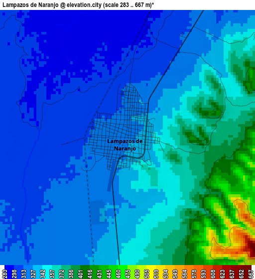
Below is the Elevation map of Lampazos de Naranjo, which displays elevation range with different colors. Scale of the first map is from 283 to 667 m (928 to 2188 ft) with average elevation of 339.6 meters (=1114 ft) [note 1]
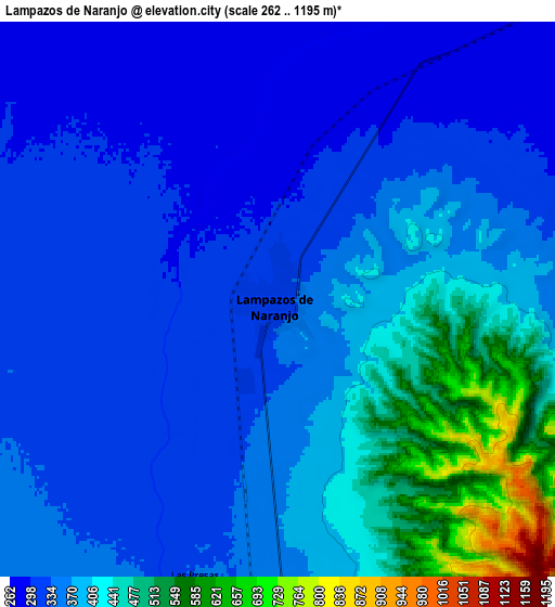
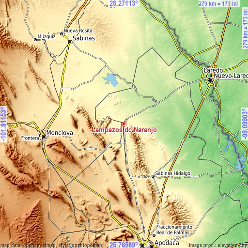
These maps also provides idea of topography and contour of this city, they are displayed at different zoom levels. More info about maps, scale and edge coordinates you can find below images.
| \ | Map #1 | Map #2 | Topo.Map |
| Scale [m] | 283..667 m | 262..1195 m | × |
| Scale [ft] | 928..2188 ft | 860..3921 ft | × |
| Average | 339.6 m = 1114 ft | 372.4 m = 1222 ft | × |
| Width | 8.71 km = 5.4 mi | 17.41 km = 10.8 mi | 278.6 km = 173.1 mi |
| Height | 8.71 km = 5.4 mi | 17.41 km = 10.8 mi | 278.6 km = 173.1 mi |
| ↑Max Latitude | 27.06463° | 27.103756° | 28.27113° |
| Latitude at center | 27.02549° | 27.02549° | 27.02549° |
| ↓Min Latitude | 26.986337° | 26.947169° | 25.76589° |
| ← Min Longitude | -100.549225° | -100.593171° | -101.91153° |
| Longitude center | -100.50528° | -100.50528° | -100.50528° |
| →Max Longitude | -100.461335° | -100.417389° | -99.09903° |
Nearby cities:
Cities around Lampazos de Naranjo sort by population:
• Monclova elevation 603 m
91.7 km,  261°
261°
• Ciudad Sabinas Hidalgo 308 m
66.3 km,  151°
151°
• Anáhuac 197 m
44.2 km,  56°
56°
• Bustamante 461 m
54.5 km,  180°
180°
• Ciudad de Villaldama 420 m
59 km,  172°
172°
• Primero de Mayo 389 m
74.9 km,  288°
288°
• Candela 428 m
26.2 km,  217°
217°
• Juárez 278 m
68.3 km,  341°
341°
• Progreso 309 m
65.5 km,  313°
313°
• Abasolo 439 m
92.9 km,  280°
280°
• Vallecillo 268 m
65.5 km,  128°
128°
• Escobedo 446 m
92.8 km, 284°
Multilingual:
 En español:
Lampazos de Naranjo elevación 326 m.
 En France:
Lampazos de Naranjo élévation 326 m.
 Auf Deutsch:
Lampazos de Naranjo höhe über dem Meeresspiegel ist 326 m.
 На русском:
Lampazos de Naranjo высота над уровнем моря 326 м
Sources and notes:
- [note 1] Map square and city borders are not equal. Map elevation data is calculated only from area inside that square.
- [src 1] Elevation data from geonames database provided with same terms of usage.
- [src 2] The elevation map of Lampazos de Naranjo is generated using elevation data from NASA's 3 arcsec (90m) resolution SRTM data.
- [src 3] Base (background) map © OpenStreetMap contributors tiles are generated by Geofabrik and OpenTopoMap.
Copyright & License:
This Lampazos de Naranjo Elevation Map is licensed under CC BY-SA. You may reuse any part from this page, if you give a proper credit by linking to this URL:
 More info on terms of use page.