Juárez elevation
Juárez (Coahuila), Mexico elevation is 278 meters and Juárez elevation in feet is 912 ft above sea level [src 1]. Juárez is a seat of a second-order administrative division (feature code) with elevation that is 1036 meters (3399 ft) smaller than average city elevation in Mexico.
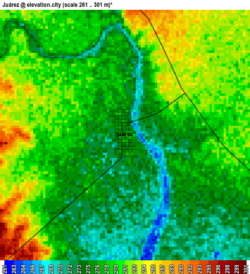
Below is the Elevation map of Juárez, which displays elevation range with different colors. Scale of the first map is from 261 to 301 m (856 to 988 ft) with average elevation of 277.8 meters (=911 ft) [note 1]
These maps also provides idea of topography and contour of this city, they are displayed at different zoom levels. More info about maps, scale and edge coordinates you can find below images.
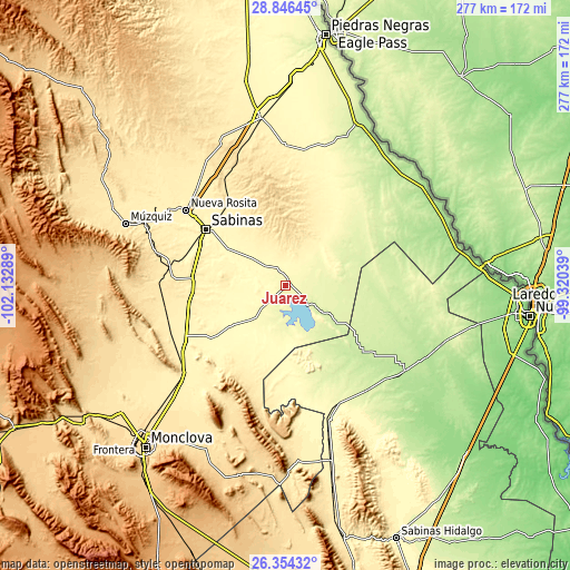
| \ | Map #1 | Topo.Map |
| Scale [m] | 261..301 m | × |
| Scale [ft] | 856..988 ft | × |
| Average | 277.8 m = 911 ft | × |
| Width | 8.66 km = 5.4 mi | 277.1 km = 172.2 mi |
| Height | 8.66 km = 5.4 mi | 277.1 km = 172.2 mi |
| ↑Max Latitude | 27.646405° | 28.84645° |
| Latitude at center | 27.60747° | 27.60747° |
| ↓Min Latitude | 27.568521° | 26.35432° |
| ← Min Longitude | -100.770585° | -102.13289° |
| Longitude center | -100.72664° | -100.72664° |
| →Max Longitude | -100.682695° | -99.32039° |
Nearby cities:
Cities around Juárez sort by population:
• Sabinas elevation 342 m
47.3 km,  305°
305°
• Nueva Rosita 391 m
60.9 km, 307°
• Minas de Barroterán 427 m
54.9 km,  275°
275°
• Villa Unión 385 m
68.4 km,  0°
0°
• Villa Union 381 m
67.7 km, 0°
• Lampazos de Naranjo 326 m
68.3 km,  161°
161°
• Cloete 365 m
56.3 km, 308°
• Villa Las Esperanzas 455 m
63.5 km, 283°
• Primero de Mayo 389 m
64.1 km,  229°
229°
• San Juan de Sabinas 382 m
67.2 km,  302°
302°
• San José de Aura 475 m
63.7 km,  268°
268°
• Progreso 309 m
32.6 km, 232°
Multilingual:
 En español:
Juárez elevación 278 m.
 En France:
Juárez élévation 278 m.


Sources and notes:
- [note 1] Map square and city borders are not equal. Map elevation data is calculated only from area inside that square.
- [src 1] Elevation data from geonames database provided with same terms of usage.
- [src 2] The elevation map of Juárez is generated using elevation data from NASA's 3 arcsec (90m) resolution SRTM data.
- [src 3] Base (background) map © OpenStreetMap contributors tiles are generated by Geofabrik and OpenTopoMap.
Copyright & License:
This Juárez Elevation Map is licensed under CC BY-SA. You may reuse any part from this page, if you give a proper credit by linking to this URL:
 More info on terms of use page.