Cañada de Caracheo elevation
Cañada de Caracheo (Guanajuato, Cortazar), Mexico elevation is 1799 meters and Cañada de Caracheo elevation in feet is 5902 ft above sea level [src 1]. Cañada de Caracheo is a populated place (feature code) with elevation that is 485 meters (1591 ft) bigger than average city elevation in Mexico.
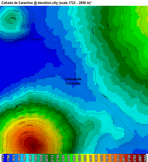
Below is the Elevation map of Cañada de Caracheo, which displays elevation range with different colors. Scale of the first map is from 1723 to 2850 m (5653 to 9350 ft) with average elevation of 1997.7 meters (=6554 ft) [note 1]
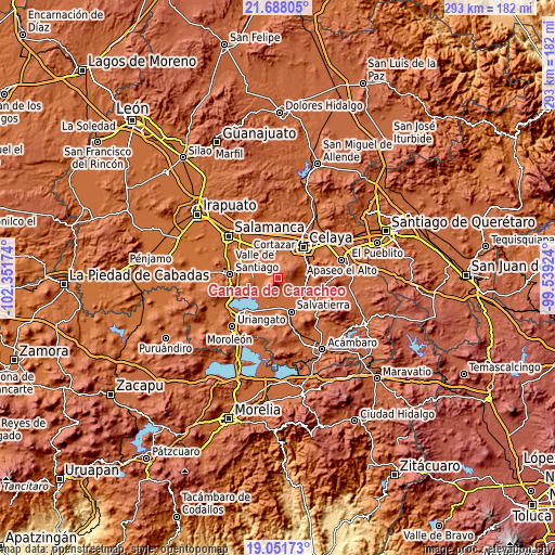
These maps also provides idea of topography and contour of this city, they are displayed at different zoom levels. More info about maps, scale and edge coordinates you can find below images.
| \ | Map #1 | Topo.Map |
| Scale [m] | 1723..2850 m | × |
| Scale [ft] | 5653..9350 ft | × |
| Average | 1997.7 m = 6554 ft | × |
| Width | 9.16 km = 5.7 mi | 293.1 km = 182.1 mi |
| Height | 9.16 km = 5.7 mi | 293.2 km = 182.2 mi |
| ↑Max Latitude | 20.41671° | 21.68805° |
| Latitude at center | 20.37552° | 20.37552° |
| ↓Min Latitude | 20.334319° | 19.05173° |
| ← Min Longitude | -100.989435° | -102.35174° |
| Longitude center | -100.94549° | -100.94549° |
| →Max Longitude | -100.901545° | -99.53924° |
Nearby cities:
Cities around Cañada de Caracheo sort by population:
• Cortazar elevation 1739 m
12.1 km,  351°
351°
• El Sabino 1755 m
12 km,  209°
209°
• Victoria de Cortazar 1729 m
10.1 km,  243°
243°
• Santiago Capitiro 1760 m
10.9 km,  223°
223°
• San José del Cerrito de Camargo 1736 m
11.2 km,  295°
295°
• El Huizache 1804 m
5.1 km,  343°
343°
• La Gavia 2355 m
7 km,  72°
72°
• La Luz 1746 m
10.1 km,  163°
163°
• El Capulín 1752 m
11.9 km,  200°
200°
• El Salvador (Ranchito San José del Carmen) 1752 m
12.1 km,  143°
143°
• Providencia 1737 m
8 km,  252°
252°
• De Parral 1732 m
11.1 km,  324°
324°
Multilingual:
 En español:
Cañada de Caracheo elevación 1799 m.
 En France:
Cañada de Caracheo élévation 1799 m.
 Auf Deutsch:
Cañada de Caracheo höhe über dem Meeresspiegel ist 1799 m.
 На русском:
Cañada de Caracheo высота над уровнем моря 1799 м
Sources and notes:
- [note 1] Map square and city borders are not equal. Map elevation data is calculated only from area inside that square.
- [src 1] Elevation data from geonames database provided with same terms of usage.
- [src 2] The elevation map of Cañada de Caracheo is generated using elevation data from NASA's 3 arcsec (90m) resolution SRTM data.
- [src 3] Base (background) map © OpenStreetMap contributors tiles are generated by Geofabrik and OpenTopoMap.
Copyright & License:
This Cañada de Caracheo Elevation Map is licensed under CC BY-SA. You may reuse any part from this page, if you give a proper credit by linking to this URL:
 More info on terms of use page.