Cortazar elevation
Cortazar (Guanajuato), Mexico elevation is 1739 meters and Cortazar elevation in feet is 5705 ft above sea level [src 1]. Cortazar is a seat of a second-order administrative division (feature code) with elevation that is 425 meters (1394 ft) bigger than average city elevation in Mexico.
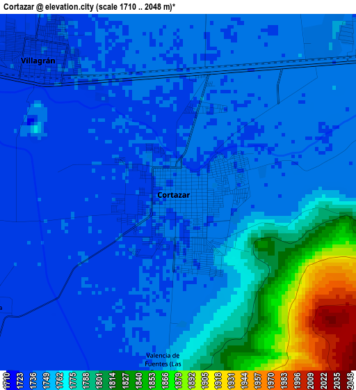
Below is the Elevation map of Cortazar, which displays elevation range with different colors. Scale of the first map is from 1710 to 2048 m (5610 to 6719 ft) with average elevation of 1759 meters (=5771 ft) [note 1]
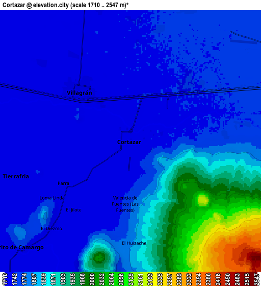
These maps also provides idea of topography and contour of this city, they are displayed at different zoom levels. More info about maps, scale and edge coordinates you can find below images.
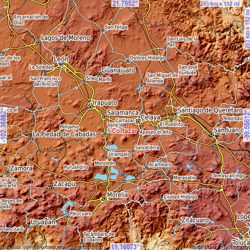
| \ | Map #1 | Map #2 | Topo.Map |
| Scale [m] | 1710..2048 m | 1710..2547 m | × |
| Scale [ft] | 5610..6719 ft | 5610..8356 ft | × |
| Average | 1759 m = 5771 ft | 1802.5 m = 5914 ft | × |
| Width | 9.15 km = 5.7 mi | 18.31 km = 11.4 mi | 292.9 km = 182 mi |
| Height | 9.15 km = 5.7 mi | 18.31 km = 11.4 mi | 292.9 km = 182 mi |
| ↑Max Latitude | 20.524781° | 20.565931° | 21.7952° |
| Latitude at center | 20.48362° | 20.48362° | 20.48362° |
| ↓Min Latitude | 20.442448° | 20.401264° | 19.16073° |
| ← Min Longitude | -101.006315° | -101.050261° | -102.36862° |
| Longitude center | -100.96237° | -100.96237° | -100.96237° |
| →Max Longitude | -100.918425° | -100.874479° | -99.55612° |
Nearby cities:
Cities around Cortazar sort by population:
• Villagrán elevation 1734 m
5 km,  313°
313°
• Tierra Fría 1730 m
8.4 km,  252°
252°
• El Huizache 1804 m
7.2 km,  177°
177°
• Los Ángeles 1746 m
8.1 km,  15°
15°
• Suchitlán 1730 m
8.4 km, 310°
• El Chinaco (El Pujido) 1742 m
6.2 km,  45°
45°
• Fraccionamiento Praderas de la Venta 1734 m
7 km,  326°
326°
• De Parral 1732 m
5.6 km,  237°
237°
• Colonia Fraccionamiento el Puente 1748 m
8.2 km,  56°
56°
• Merino 1746 m
8.2 km,  81°
81°
• Santa Fe de la Purísima 1747 m
7.4 km, 79°
• Colonia la Calzada (La Olla) 1736 m
2.2 km,  9°
9°
Multilingual:
 En español:
Cortazar elevación 1739 m.
 En France:
Cortazar élévation 1739 m.
 Auf Deutsch:
Cortazar höhe über dem Meeresspiegel ist 1739 m.

Sources and notes:
- [note 1] Map square and city borders are not equal. Map elevation data is calculated only from area inside that square.
- [src 1] Elevation data from geonames database provided with same terms of usage.
- [src 2] The elevation map of Cortazar is generated using elevation data from NASA's 3 arcsec (90m) resolution SRTM data.
- [src 3] Base (background) map © OpenStreetMap contributors tiles are generated by Geofabrik and OpenTopoMap.
Copyright & License:
This Cortazar Elevation Map is licensed under CC BY-SA. You may reuse any part from this page, if you give a proper credit by linking to this URL:
 More info on terms of use page.