Los Ángeles elevation
Los Ángeles (Guanajuato, Villagrán), Mexico elevation is 1746 meters and Los Ángeles elevation in feet is 5728 ft above sea level [src 1]. Los Ángeles is a populated place (feature code) with elevation that is 432 meters (1417 ft) bigger than average city elevation in Mexico.
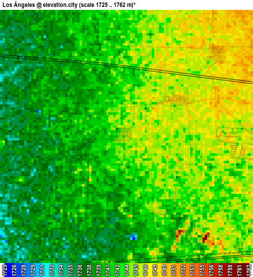
Below is the Elevation map of Los Ángeles, which displays elevation range with different colors. Scale of the first map is from 1725 to 1762 m (5659 to 5781 ft) with average elevation of 1741.9 meters (=5715 ft) [note 1]
These maps also provides idea of topography and contour of this city, they are displayed at different zoom levels. More info about maps, scale and edge coordinates you can find below images.
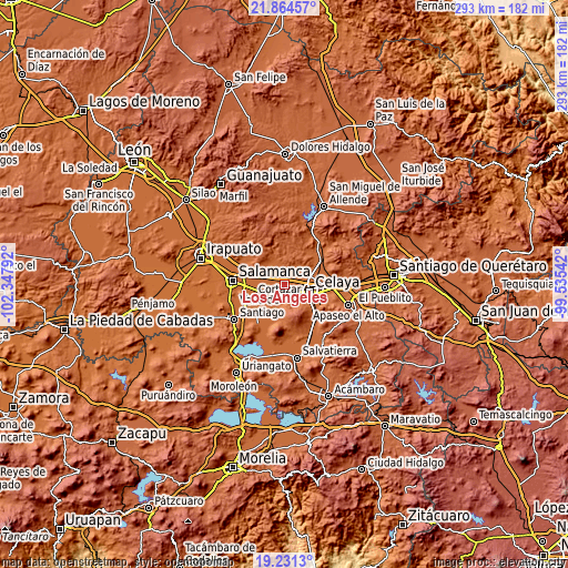
| \ | Map #1 | Topo.Map |
| Scale [m] | 1725..1762 m | × |
| Scale [ft] | 5659..5781 ft | × |
| Average | 1741.9 m = 5715 ft | × |
| Width | 9.15 km = 5.7 mi | 292.8 km = 181.9 mi |
| Height | 9.15 km = 5.7 mi | 292.8 km = 181.9 mi |
| ↑Max Latitude | 20.594752° | 21.86457° |
| Latitude at center | 20.55361° | 20.55361° |
| ↓Min Latitude | 20.512457° | 19.2313° |
| ← Min Longitude | -100.985615° | -102.34792° |
| Longitude center | -100.94167° | -100.94167° |
| →Max Longitude | -100.897725° | -99.53542° |
Nearby cities:
Cities around Los Ángeles sort by population:
• Santa Rosa los Angeles elevation 1748 m
2.3 km,  54°
54°
• San José de Guanajuato 1749 m
5.1 km,  86°
86°
• San Antonio de los Morales 1750 m
4.4 km, 47°
• Franco Tavera 1749 m
6 km,  14°
14°
• El Chinaco (El Pujido) 1742 m
4.2 km,  146°
146°
• Fraccionamiento Praderas de la Venta 1734 m
6.4 km,  252°
252°
• San Salvador Torrecillas 1743 m
1.8 km,  292°
292°
• Colonia Patria Nueva 1750 m
7.1 km,  113°
113°
• Colonia Fraccionamiento el Puente 1748 m
5.8 km,  125°
125°
• El Caracol 1739 m
4.5 km, 289°
• Colonia la Calzada (La Olla) 1736 m
5.9 km,  197°
197°
• San Antonio de Romerillo 1745 m
6.1 km,  353°
353°
Multilingual:
 En español:
Los Ángeles elevación 1746 m.
 En France:
Los Ángeles élévation 1746 m.
 Auf Deutsch:
Los Ángeles höhe über dem Meeresspiegel ist 1746 m.

Sources and notes:
- [note 1] Map square and city borders are not equal. Map elevation data is calculated only from area inside that square.
- [src 1] Elevation data from geonames database provided with same terms of usage.
- [src 2] The elevation map of Los Ángeles is generated using elevation data from NASA's 3 arcsec (90m) resolution SRTM data.
- [src 3] Base (background) map © OpenStreetMap contributors tiles are generated by Geofabrik and OpenTopoMap.
Copyright & License:
This Los Ángeles Elevation Map is licensed under CC BY-SA. You may reuse any part from this page, if you give a proper credit by linking to this URL:
 More info on terms of use page.