Citala elevation
Citala (Jalisco, Teocuitatlán de Corona), Mexico elevation is 1409 meters and Citala elevation in feet is 4623 ft above sea level [src 1]. Citala is a populated place (feature code) with elevation that is 95 meters (312 ft) bigger than average city elevation in Mexico.
Below is the Elevation map of Citala, which displays elevation range with different colors. Scale of the first map is from 1378 to 2100 m (4521 to 6890 ft) with average elevation of 1653.6 meters (=5425 ft) [note 1]
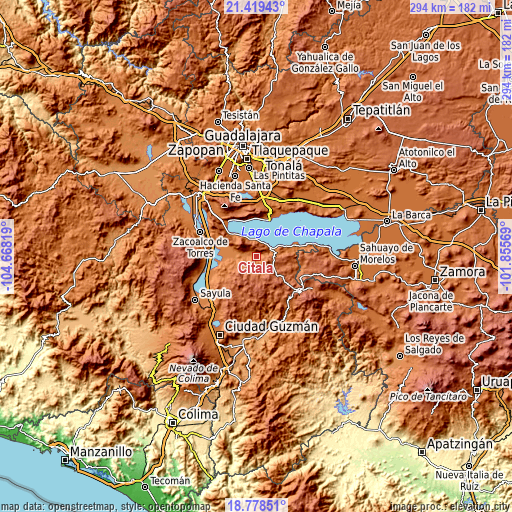
These maps also provides idea of topography and contour of this city, they are displayed at different zoom levels. More info about maps, scale and edge coordinates you can find below images.
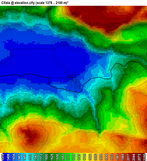
| \ | Map #1 | Topo.Map |
| Scale [m] | 1378..2100 m | × |
| Scale [ft] | 4521..6890 ft | × |
| Average | 1653.6 m = 5425 ft | × |
| Width | 9.18 km = 5.7 mi | 293.6 km = 182.4 mi |
| Height | 9.18 km = 5.7 mi | 293.7 km = 182.5 mi |
| ↑Max Latitude | 20.145802° | 21.41943° |
| Latitude at center | 20.10454° | 20.10454° |
| ↓Min Latitude | 20.063267° | 18.77851° |
| ← Min Longitude | -103.305885° | -104.66819° |
| Longitude center | -103.26194° | -103.26194° |
| →Max Longitude | -103.217995° | -101.85569° |
Nearby cities:
Cities around Citala sort by population:
• Chapala elevation 1539 m
22.5 km,  19°
19°
• Tizapán el Alto 1542 m
23.6 km,  74°
74°
• Ajijic 1577 m
22.1 km,  1°
1°
• San Juan Cosalá 1536 m
22 km,  337°
337°
• Concepción de Buenos Aires 2135 m
14 km,  179°
179°
• Teocuitatlán de Corona 1380 m
12.2 km,  263°
263°
• San Luis Soyatlán 1540 m
11.4 km, 335°
• La Manzanilla de la Paz 2057 m
15.8 km,  134°
134°
• San Cristóbal Zapotitlán 1538 m
17.4 km,  319°
319°
• Santa Cruz de la Soledad 1543 m
26 km, 24°
• Tuxcueca 1534 m
9.7 km,  55°
55°
• San Pedro Tesistán 1555 m
21 km,  310°
310°
Multilingual:
 En español:
Citala elevación 1409 m.
 En France:
Citala élévation 1409 m.


Sources and notes:
- [note 1] Map square and city borders are not equal. Map elevation data is calculated only from area inside that square.
- [src 1] Elevation data from geonames database provided with same terms of usage.
- [src 2] The elevation map of Citala is generated using elevation data from NASA's 3 arcsec (90m) resolution SRTM data.
- [src 3] Base (background) map © OpenStreetMap contributors tiles are generated by Geofabrik and OpenTopoMap.
Copyright & License:
This Citala Elevation Map is licensed under CC BY-SA. You may reuse any part from this page, if you give a proper credit by linking to this URL:
 More info on terms of use page.