San Luis Soyatlán elevation
San Luis Soyatlán (Jalisco, Tuxcueca), Mexico elevation is 1540 meters and San Luis Soyatlán elevation in feet is 5052 ft above sea level [src 1]. San Luis Soyatlán is a populated place (feature code) with elevation that is 226 meters (741 ft) bigger than average city elevation in Mexico.
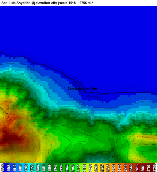
Below is the Elevation map of San Luis Soyatlán, which displays elevation range with different colors. Scale of the first map is from 1518 to 2756 m (4980 to 9042 ft) with average elevation of 1758.3 meters (=5769 ft) [note 1]
These maps also provides idea of topography and contour of this city, they are displayed at different zoom levels. More info about maps, scale and edge coordinates you can find below images.
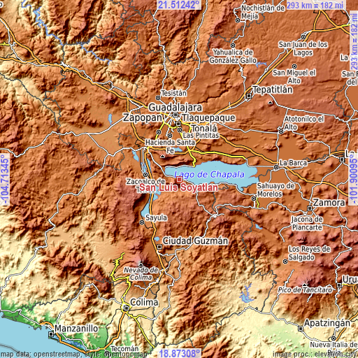
| \ | Map #1 | Topo.Map |
| Scale [m] | 1518..2756 m | × |
| Scale [ft] | 4980..9042 ft | × |
| Average | 1758.3 m = 5769 ft | × |
| Width | 9.17 km = 5.7 mi | 293.5 km = 182.4 mi |
| Height | 9.17 km = 5.7 mi | 293.5 km = 182.4 mi |
| ↑Max Latitude | 20.239577° | 21.51242° |
| Latitude at center | 20.19834° | 20.19834° |
| ↓Min Latitude | 20.157092° | 18.87308° |
| ← Min Longitude | -103.351145° | -104.71345° |
| Longitude center | -103.3072° | -103.3072° |
| →Max Longitude | -103.263255° | -101.90095° |
Nearby cities:
Cities around San Luis Soyatlán sort by population:
• Chapala elevation 1539 m
16.3 km,  48°
48°
• Jocotepec 1544 m
16 km,  307°
307°
• Ajijic 1577 m
12.9 km,  25°
25°
• San Juan Cosalá 1536 m
10.5 km,  340°
340°
• Ixtlahuacán de los Membrillos 1601 m
20.5 km,  35°
35°
• Teocuitatlán de Corona 1380 m
13.9 km,  212°
212°
• San Cristóbal Zapotitlán 1538 m
7.1 km,  294°
294°
• Santa Cruz de la Soledad 1543 m
20.4 km, 49°
• Potrerillos 1844 m
17.2 km,  334°
334°
• Tuxcueca 1534 m
13.7 km,  111°
111°
• San Pedro Tesistán 1555 m
11.7 km, 285°
• Citala 1409 m
11.4 km,  155°
155°
Multilingual:
 En español:
San Luis Soyatlán elevación 1540 m.
 En France:
San Luis Soyatlán élévation 1540 m.
 Auf Deutsch:
San Luis Soyatlán höhe über dem Meeresspiegel ist 1540 m.
 На русском:
San Luis Soyatlán высота над уровнем моря 1540 м
Sources and notes:
- [note 1] Map square and city borders are not equal. Map elevation data is calculated only from area inside that square.
- [src 1] Elevation data from geonames database provided with same terms of usage.
- [src 2] The elevation map of San Luis Soyatlán is generated using elevation data from NASA's 3 arcsec (90m) resolution SRTM data.
- [src 3] Base (background) map © OpenStreetMap contributors tiles are generated by Geofabrik and OpenTopoMap.
Copyright & License:
This San Luis Soyatlán Elevation Map is licensed under CC BY-SA. You may reuse any part from this page, if you give a proper credit by linking to this URL:
 More info on terms of use page.