Coahuayutla de Guerrero elevation
Coahuayutla de Guerrero (Guerrero, Coahuayutla de José María Izazaga), Mexico elevation is 313 meters and Coahuayutla de Guerrero elevation in feet is 1027 ft above sea level [src 1]. Coahuayutla de Guerrero is a seat of a second-order administrative division (feature code) with elevation that is 1001 meters (3284 ft) smaller than average city elevation in Mexico.
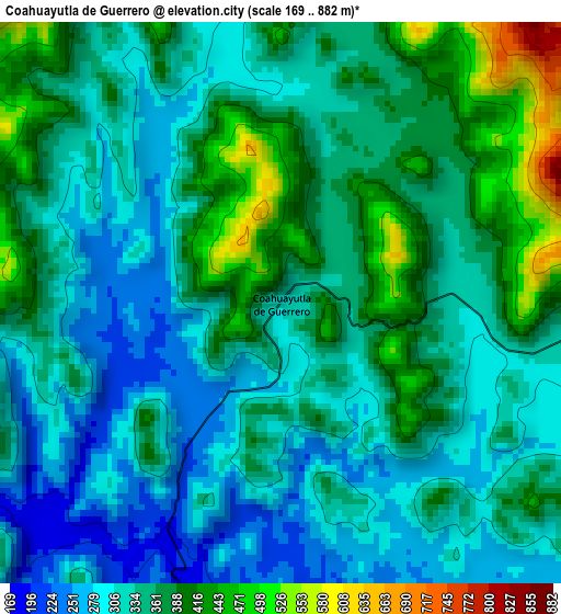
Below is the Elevation map of Coahuayutla de Guerrero, which displays elevation range with different colors. Scale of the first map is from 169 to 882 m (554 to 2894 ft) with average elevation of 346.1 meters (=1135 ft) [note 1]
These maps also provides idea of topography and contour of this city, they are displayed at different zoom levels. More info about maps, scale and edge coordinates you can find below images.
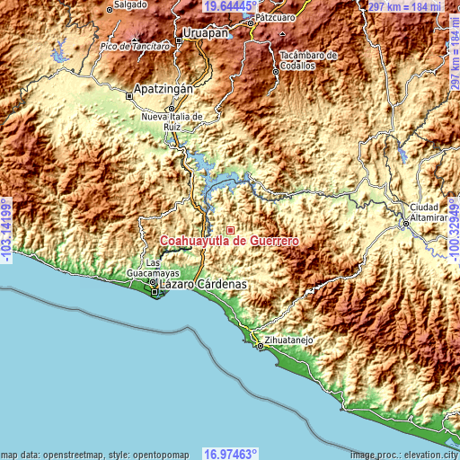
| \ | Map #1 | Topo.Map |
| Scale [m] | 169..882 m | × |
| Scale [ft] | 554..2894 ft | × |
| Average | 346.1 m = 1135 ft | × |
| Width | 9.28 km = 5.8 mi | 296.9 km = 184.5 mi |
| Height | 9.28 km = 5.8 mi | 296.9 km = 184.5 mi |
| ↑Max Latitude | 18.356404° | 19.64445° |
| Latitude at center | 18.31469° | 18.31469° |
| ↓Min Latitude | 18.272966° | 16.97463° |
| ← Min Longitude | -101.779685° | -103.14199° |
| Longitude center | -101.73574° | -101.73574° |
| →Max Longitude | -101.691795° | -100.32949° |
Nearby cities:
Cities around Coahuayutla de Guerrero sort by population:
• Arteaga elevation 829 m
58.8 km,  274°
274°
• Churumuco de Morelos 201 m
39.9 km,  13°
13°
• La Unión 64 m
37.3 km,  191°
191°
• Petacalco 10 m
54.1 km,  226°
226°
• Infiernillo (Morelos de Infiernillo) 80 m
17.8 km,  258°
258°
• Guayameo 642 m
50.1 km,  91°
91°
• Lagunillas 50 m
54.6 km,  177°
177°
• Aratichanguío 216 m
43.4 km,  65°
65°
• Zacatula 16 m
57.9 km, 234°
• Poturo 535 m
58.3 km, 12°
• El Naranjito 12 m
57.5 km, 230°
• Las Cañas 341 m
37.7 km,  317°
317°
Multilingual:
 En español:
Coahuayutla de Guerrero elevación 313 m.
 En France:
Coahuayutla de Guerrero élévation 313 m.
 Auf Deutsch:
Coahuayutla de Guerrero höhe über dem Meeresspiegel ist 313 m.
 На русском:
Coahuayutla de Guerrero высота над уровнем моря 313 м
Sources and notes:
- [note 1] Map square and city borders are not equal. Map elevation data is calculated only from area inside that square.
- [src 1] Elevation data from geonames database provided with same terms of usage.
- [src 2] The elevation map of Coahuayutla de Guerrero is generated using elevation data from NASA's 3 arcsec (90m) resolution SRTM data.
- [src 3] Base (background) map © OpenStreetMap contributors tiles are generated by Geofabrik and OpenTopoMap.
Copyright & License:
This Coahuayutla de Guerrero Elevation Map is licensed under CC BY-SA. You may reuse any part from this page, if you give a proper credit by linking to this URL:
 More info on terms of use page.