Arteaga elevation
Arteaga (Michoacán), Mexico elevation is 829 meters and Arteaga elevation in feet is 2720 ft above sea level [src 1]. Arteaga is a seat of a second-order administrative division (feature code) with elevation that is 485 meters (1591 ft) smaller than average city elevation in Mexico.
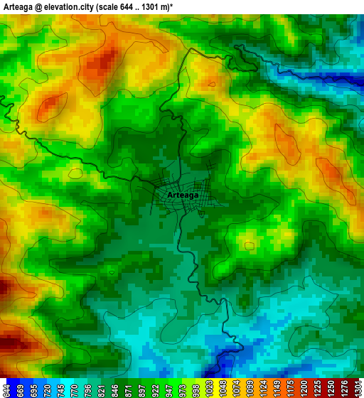
Below is the Elevation map of Arteaga, which displays elevation range with different colors. Scale of the first map is from 644 to 1301 m (2113 to 4268 ft) with average elevation of 919.7 meters (=3017 ft) [note 1]
These maps also provides idea of topography and contour of this city, they are displayed at different zoom levels. More info about maps, scale and edge coordinates you can find below images.
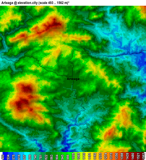
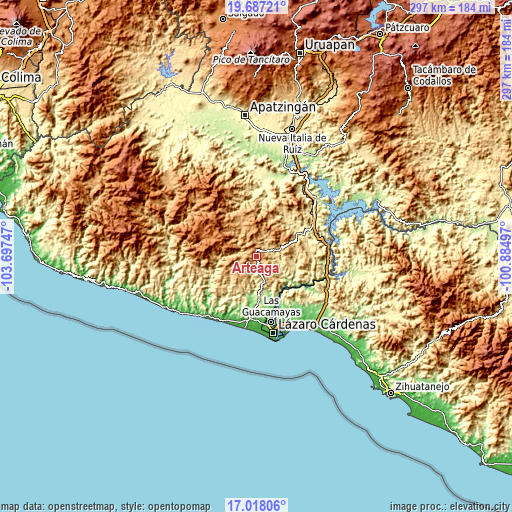
| \ | Map #1 | Map #2 | Topo.Map |
| Scale [m] | 644..1301 m | 493..1562 m | × |
| Scale [ft] | 2113..4268 ft | 1617..5125 ft | × |
| Average | 919.7 m = 3017 ft | 915.1 m = 3002 ft | × |
| Width | 9.28 km = 5.8 mi | 18.55 km = 11.5 mi | 296.8 km = 184.4 mi |
| Height | 9.28 km = 5.8 mi | 18.55 km = 11.5 mi | 296.8 km = 184.4 mi |
| ↑Max Latitude | 18.399494° | 18.441188° | 19.68721° |
| Latitude at center | 18.35779° | 18.35779° | 18.35779° |
| ↓Min Latitude | 18.316076° | 18.274352° | 17.01806° |
| ← Min Longitude | -102.335165° | -102.379111° | -103.69747° |
| Longitude center | -102.29122° | -102.29122° | -102.29122° |
| →Max Longitude | -102.247275° | -102.203329° | -100.88497° |
Nearby cities:
Cities around Arteaga sort by population:
• Guacamayas elevation 25 m
38.5 km,  167°
167°
• La Orilla 23 m
40.8 km, 170°
• La Mira Tumbiscatio 495 m
36.2 km,  1°
1°
• La Mira 50 m
36.2 km,  185°
185°
• Buenos Aires 63 m
37.1 km,  179°
179°
• Playa Azul 9 m
42.2 km, 188°
• Tumbiscatío de Ruiz 919 m
20.9 km,  333°
333°
• Infiernillo (Morelos de Infiernillo) 80 m
42 km,  101°
101°
• Acalpican de Morelos 27 m
38.1 km, 187°
• El Habillal 11 m
39.9 km, 192°
• Zacatula 16 m
40.5 km,  163°
163°
• Las Cañas 341 m
40.5 km,  55°
55°
Multilingual:
 En español:
Arteaga elevación 829 m.
 En France:
Arteaga élévation 829 m.


Sources and notes:
- [note 1] Map square and city borders are not equal. Map elevation data is calculated only from area inside that square.
- [src 1] Elevation data from geonames database provided with same terms of usage.
- [src 2] The elevation map of Arteaga is generated using elevation data from NASA's 3 arcsec (90m) resolution SRTM data.
- [src 3] Base (background) map © OpenStreetMap contributors tiles are generated by Geofabrik and OpenTopoMap.
Copyright & License:
This Arteaga Elevation Map is licensed under CC BY-SA. You may reuse any part from this page, if you give a proper credit by linking to this URL:
 More info on terms of use page.