La Orilla elevation
La Orilla (Michoacán, Lázaro Cárdenas), Mexico elevation is 23 meters and La Orilla elevation in feet is 75 ft above sea level [src 1]. La Orilla is a populated place (feature code) with elevation that is 1291 meters (4236 ft) smaller than average city elevation in Mexico.
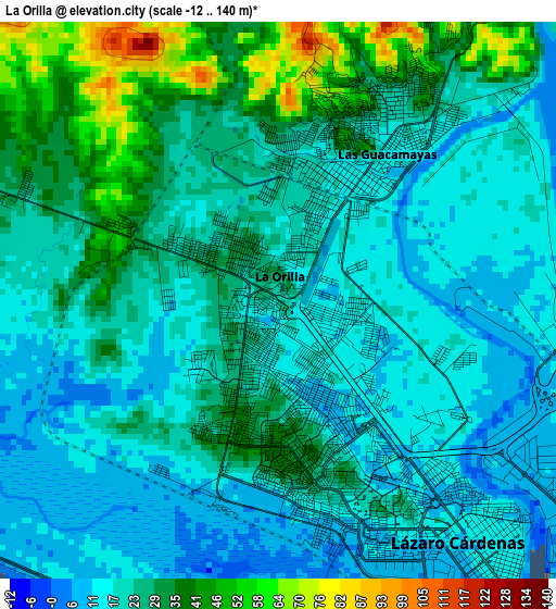
Below is the Elevation map of La Orilla, which displays elevation range with different colors. Scale of the first map is from -12 to 140 m (-39 to 459 ft) with average elevation of 23.9 meters (=78 ft) [note 1]
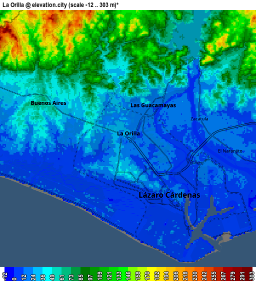
These maps also provides idea of topography and contour of this city, they are displayed at different zoom levels. More info about maps, scale and edge coordinates you can find below images.
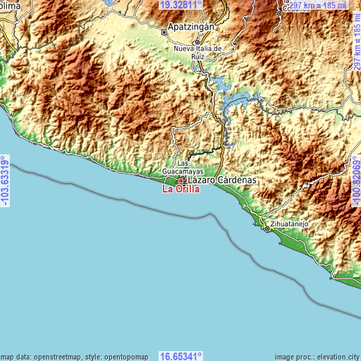
| \ | Map #1 | Map #2 | Topo.Map |
| Scale [m] | -12..140 m | -12..303 m | × |
| Scale [ft] | -39..459 ft | -39..994 ft | × |
| Average | 23.9 m = 78 ft | 50.6 m = 166 ft | × |
| Width | 9.29 km = 5.8 mi | 18.59 km = 11.6 mi | 297.4 km = 184.8 mi |
| Height | 9.29 km = 5.8 mi | 18.59 km = 11.6 mi | 297.4 km = 184.8 mi |
| ↑Max Latitude | 18.037621° | 18.079401° | 19.32811° |
| Latitude at center | 17.99583° | 17.99583° | 17.99583° |
| ↓Min Latitude | 17.95403° | 17.912219° | 16.65341° |
| ← Min Longitude | -102.270885° | -102.314831° | -103.63319° |
| Longitude center | -102.22694° | -102.22694° | -102.22694° |
| →Max Longitude | -102.182995° | -102.139049° | -100.82069° |
Nearby cities:
Cities around La Orilla sort by population:
• Ciudad Lázaro Cárdenas elevation 27 m
2.9 km,  167°
167°
• Guacamayas 25 m
3 km,  30°
30°
• La Mira 50 m
11.2 km,  291°
291°
• Arteaga 829 m
40.8 km,  350°
350°
• Buenos Aires 63 m
7 km,  297°
297°
• La Unión 64 m
44.5 km,  91°
91°
• Playa Azul 9 m
12.9 km,  262°
262°
• Petacalco 10 m
12.6 km,  97°
97°
• Acalpican de Morelos 27 m
12.3 km,  281°
281°
• El Habillal 11 m
15.5 km,  274°
274°
• Zacatula 16 m
5.3 km,  72°
72°
• El Naranjito 12 m
7.4 km, 96°
Multilingual:
 En español:
La Orilla elevación 23 m.
 En France:
La Orilla élévation 23 m.
 Auf Deutsch:
La Orilla höhe über dem Meeresspiegel ist 23 m.

Sources and notes:
- [note 1] Map square and city borders are not equal. Map elevation data is calculated only from area inside that square.
- [src 1] Elevation data from geonames database provided with same terms of usage.
- [src 2] The elevation map of La Orilla is generated using elevation data from NASA's 3 arcsec (90m) resolution SRTM data.
- [src 3] Base (background) map © OpenStreetMap contributors tiles are generated by Geofabrik and OpenTopoMap.
Copyright & License:
This La Orilla Elevation Map is licensed under CC BY-SA. You may reuse any part from this page, if you give a proper credit by linking to this URL:
 More info on terms of use page.